Actual clockwork – the works that solved the problem of how to sail across an ocean safely by keeping proper time for navigation. And, these clocks from the 1700’s are still ticking!
IN THAT CLIP: Harrison’s four timepieces that revolutionized navigation and long distance sea travel.
I visited the Royal Observatory in Greenwich, England this month. Been on my list since I first read “Longitude” by Dava Sobel, about the English crafstman and inventor John Harrison. I’ve written about it before, but now I’ve seen it.
“You have to see it to understand. Now I’ve seen it.”
The Dragon Queen, Game of Thrones
(I also saw the dragon motifs in Wales, and got some great drag swag, but that’s another story from the same trip.)
Harrison’s clocks revolutionized sea travel and have withstood the test of time. It took him most of his adult lifetime, partially because he was a self-sabotaging perfectionist, but he solved the problem of his time: how to determine longitude at sea. His timepieces were the first chronometers, or very accurate time pieces that would work for extended sea voyages without adjustment or maintenance. And, he won the incentive prize offered by Parliament: 20,000 pounds. That translates into roughly $7 million when adjusted to today’s value.
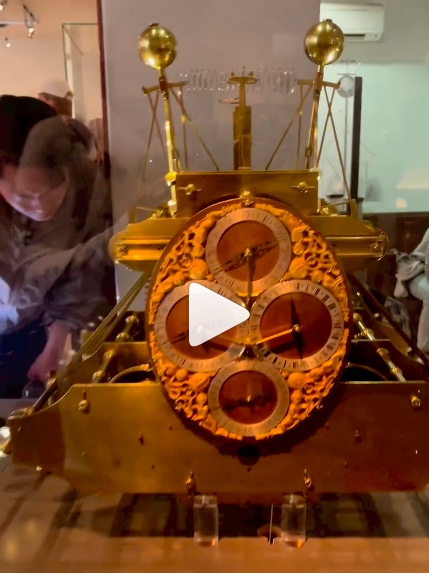
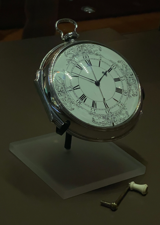
IN THAT PIC: His first chronometer clock, H1. Kept good time near-coastal in Europe.
Why was this a problem to begin with?
To determine longitudinal position at sea (east/west), one needed to know the time at the home port of departure (now Greenwich, England, or GMT for all) and compare it to the local apparent noon (sun at its zenith).
To do that, one needed an accurate time piece.
They existed on land, but none of the day could keep time at sea due to the motion of the ocean, as well as changes in humidity and barometric pressure.
Until the problem was solved, vessels were constantly at risk of delayed or premature arrivals, getting lost, or worse, running aground. That last eventuality was the straw that broke the stiff upper lip of the land: a small armada was lost off the coat of England due to poor position reckoning.
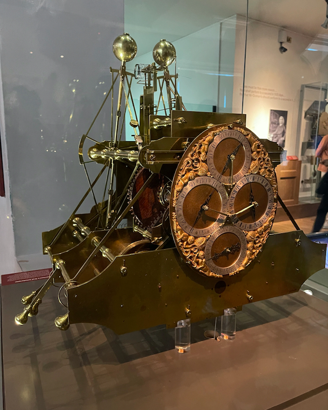
IN THAT PIC: H2. Tried to sole some problems; he found another. NEXT!..
The detailed history is best left to Dava Sobel, but suffice it to say it that this wasn’t an easy affair. Here’s a super-short summary.
In 1714, Parliament created the Board of Longitude and offered the prize.
In the 1720’s, Harrison created his first clock. It was huge, unwieldy, and elegant a/f – so much so that a fancy-lad clockmaker in England makes stunning replicas.
It worked well enough on a proper sea trial, and it was duly recognized by the Board, but there was room for improvement. A small sum was paid with the promise that another improved clock would be built.
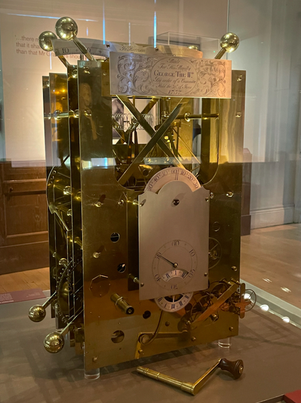
IN THAT PIC: H3 Not good enough. The can of worms, they squirms…
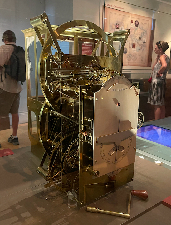
It took three more iterations, decades of time, and some political jockeying to get it done…. but the fourth time was the charm. From a large machine, to a large pocket watch, Harrison created a consistently reliable chronometer and safe navigation was possible. Sadly, despite this accomplishment and also winning the king’s ransom of a prize, he died a bitter and broken man.
IN THAT PIC: H4. DONE. Kept accurate time from England to the Caribbean.
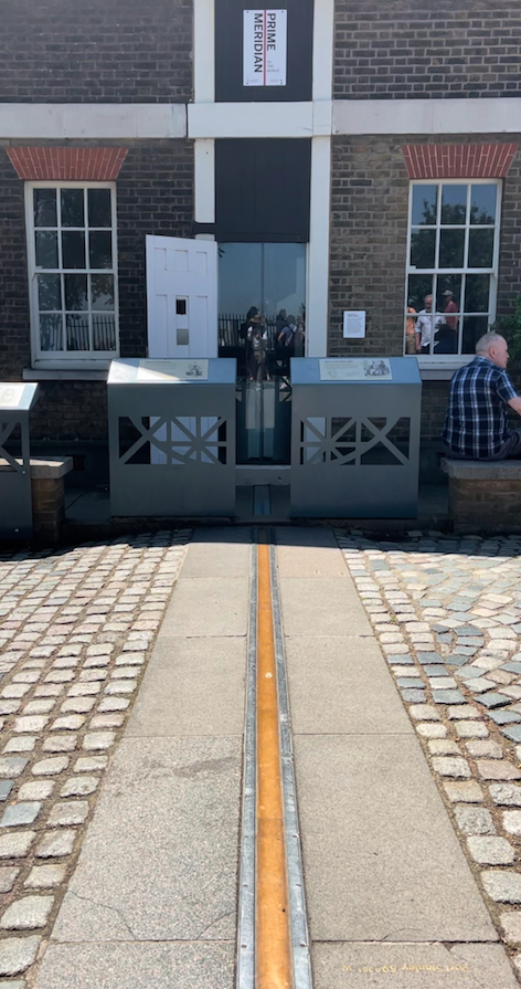
But, I was a happy fan at the Royal Observatory. I highly recommend anyone traveling to London take a side trip to Greenwich, which also has the Maritime Museum and the Cutty Sark. Easy on tube + rail. Harrison’s clocks might be the best part about the Observatory but there’s plenty more, including the touristy thing: standing on the Prime Meridian!
Again: read Longitude by Dava Sobel. Get the illustrated version. Fascinating and revealing. There’s also a Nova episode about it, and despite being a little campy with reenactments, it’s great. Sobel is interviewed in it.
We teach the basics of latitude and longitude work in our Coastal Navigation course, Start Sailing (ASA 105), including how to use lat/lon coordinates from a GPS to plot position on a paper chart. Old school blended with new.
When learning how to navigate or sail a boat, currents and tides sometimes have something to say. Which causes the other – current, or tide?
We ask this in each schedule of Start NavigatingSM, our ASA 105 Coastal Navigation course. I have a strong opinion on this. Apparently, it agreed with NOAA and NOS. They had a “Did you know?..” posted on one page, and it said what I thought already: one causes the other, despite the conventional wisdom being otherwise.
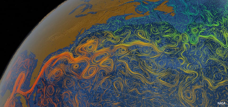
IN THAT PIC: a visualization of the Gulf Stream, spanning the vast areas from the Gulf of Mexico to the shores of Western Europe! It’s shown here with different colors reflecting sea surface temperatures. Courtesy of NASA. The Gulf Stream is a prevailing, steady-ish current (not a ‘tidal’ current).
Of course, when this topic arose again recently, due to ASA sending an e-blast concurring with the conventional wisdom, I was ready to sink my chops into it. Here’s what they said…
Tides are the vertical movement of water caused by the gravitational fields of the sun and the moon acting on bodies of water. Tidal Currents are the result of water moving between high and low tides.
Zeke Quezada, “TIPS FROM THE TEXT ‘TIDES & CURRENTS,'” on ASA’s site and in their January 27 e-blast.
So… celestial gravity raises earth’s waters, forming currents that fill in the gap? Nahhh…. Hard no, IMHO. Where was that NOAA page? I went looking for it.
Two weeks later: still looking. They seem to have deleted that page, and / or edited it and others. And, they have mixed statements about how this all interrelates. That got me thinking again about the topic, and further researching it. Most explanations I came across seemed somewhere between lame and oversimplified. But, most of them shared a common assumption of facts that were supported by an astrophysicist who I’ll cite below. He sought to debunk the common explanations of those facts. As did I.
I wrote him but haven’t heard back yet. I also reached out to a good friend who’s a PHD candidate in climate science at Columbia. She supported my explanation, and also noted that it’s a tricky topic to teach and that her students usually have trouble with it.
Let’s try to decipher this. What are currents and tides generally? What’s the difference between them? That part is simple.
CURRENT is any horizontal motion of earth’s waters across the face of it (back and forth; in and out).
TIDE is any vertical motion of earth’s waters (up and down).
What causes this to happen? Let’s limit this to interrelated current and tide, and leave out anything about wind driven currents or those caused the the rotation of earth (both of which are separate phenomena from tide and tidal current). Back to cause and effect:
The gravity of the moon mostly, with a little less than half of the forces caused by the sun.
Yup. “It is known.”
But, that’s both the beginning and the end of what people pretty much agree on. So let’s flesh out what the author here – me – thinks. Methinks. (Yes, grammatically incorrect x 2. So sue.)
What causes the “motion of the ocean?”
The gravitational pull of the moon, mostly, with less than half the total force being from the more powerful but far more distant sun. Their combined gravity pulls the earth’s waters around, causing cycles every day. We have two high tides and two low tides each day as the waters bunch up in response to celestial gravity. Because the tides are based on the moon much more than the sun, it takes a little over one “day” for the completion of all the cycles – around 50 minutes or so. (The moon rises later each night, in case you hadn’t noticed. That’s due to the moon’s orbit around earth.)
As the water chases the gravity, it flows horizontally across the earth’s surface, which is what we call current. As water leaves one area, it drops vertically, and as it bunches up in another, it rises. Therefore, current flow causes the rise and fall we call tide.
The Motion of the Ocean, excerpt from “Navigation for Numbskulls,” or How to get from A to B Without Hitting C. Captain Stephen Glenn Card (I authored the text in 2002, updating occasionally, and it’s the companion textbook we use for the ASA 105 Coastal Navigation course, Start Navigating. )
When people say that tide causes current, it implies that the moon stretches or lifts earth’s waters vertically, and pulls in water from other areas in the form of current. Neither the moon nor the sun has the gravitational force to actually lift earth’s waters.
Analogy, for those who like them: imagine the force required to push a boat through the water at a dock with one hand on a calm, still day. It’s pretty easy. Then, imagine lifting that boat out of the water and up into the air. That requires a multi-ton hoist. The concept is the same for cosmic gravity moving earth’s waters. It’s easy to pull them across earth, and impossible to lift them up and away from it.
But, don’t take my word for it… here are two videos and a pulled paragraph that sort of resonate with what I’m saying…
Neil deGrasse Tyson, a man who needs no introduction, speaking on Star Talk.
Gabe Perez-Giz, an astronomer and astrophysicist at NYU, on PBS’ Space Time
And, here’s a quote pulled from NOAA’s site (National Oceanic and Atmospheric Administration)…
TIDES
If you live near the coast or have ever visited the beach, you are probably aware of tides. But did you know that tides are really big waves that move through the ocean in response to the forces exerted by the Moon and the Sun? Tides start in the ocean and move towards the coast, where they appear as the regular rise and fall of the sea surface. How much the water level changes over the day varies depending on where you are and what day it is.
NOAA, in their abstract / synopsis of tides and currents. https://oceanservice.noaa.gov/navigation/tidesandcurrents/
Here’s another… also NOAA: Physical Oceanographer Greg Dusek, a senior scientist at NOAA’s Tides and Currents Office…
…And that affects water levels too, because you’re pushing either water away from shore so you have a little bit of a decrease in water level, or you’re pushing water towards shore and you have an increase in water level.
…When the Gulf Stream slows down, you can see increases of water level along the Southeast coast by several inches to maybe a foot. In some cases, it happens pretty regularly. So in North and South Carolina, you get a regular increase in water level in the fall because the Gulf Stream tends to be a little bit slower during those time periods.
Greg Dusek, NOAA Ocean Podcast Episode 15, “Tides and Currents: the Motion of the Ocean” (not to be confused with this author’s identical section title from his book, as I came up with the phrase on my own. So there.) Dusek’s topic here was mostly ocean currents like the Gulf Stream as caused and influenced by earth’s rotational force.
I repeat: “tides start in the ocean and move towards the coast” (translation: current)
…where they appear as the regular rise and fall of the sea surface.” (translation: tide.)
So, on a simply descriptive basis, with or without the terms current &/or tide, NOAA’s explanations agree with mine. And, everyone agrees that current is horizontal and tide vertical.
Add all this up…
Tyson: earth revolves through the tidal bulge caused by the moon (horizontal motions of earths surface and/or waters)
Perez-Giz: the moon does not lift or stretch the earth’s waters.
NOAA: ocean waters travel toward the coasts, where they rise and fall.
Card’s Conclusion: current causes tide.
Hopefully, this clears it up more than clouding it. What do you think? Weigh in!
Our Director, and most prolific instructor, scored 3.92 out of 4 so far in 2022! THIS is how we teach people how to sail in Brooklyn and City Island.
Year to date, 2022: Captain Stephen Glenn Card, our Director, “Dockmaster” and author of our Blog Rants, has a near-perfect record thus far. Unless there’s a seriously negative ballot-box drop in the next few week, which basically can’t happen, that’s that with that.
Captain Card explaining the gift of lift – or, how sails work most of the time. Quick shoreside preview before going out and doing it for real.
And, we’re not talking about an average of 1 or 2 reviews. 20 were submitted, which is a meaningful amount statistically (and particularly in our industry.)
How does this work? ASA sends a confidential email survey to all students who have course certifications processed. Some students respond, and answer key question about how their course went. Their responses are strictly confidential: schools and instructors never know who said what about the where now. Instructors can only see how many reviews were done, and when, plus a breakdown of scoring for each question (not each student).
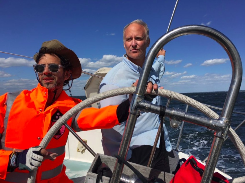
Dinghy Captain (every trip has one) Steve clowning for the camera while simultaneously towing a stranded dinghy from another cruising yacht (the little outboard that couldn’t). Off Marina Cay and Scrub Island, BVI, literally days before the pandemic lockdown in ’20.
And, ASA issues Instructor of the Year awards based on these. Assuming an instructor gets a minimum number of responses (ASA doesn’t’ disclose what that is), they’re in the running based on their cumulative score for the calendar year.
Will 3.91 be enough to win one for our Dockmaster? Doubt it; he’s always scored quite highly and hasn’t won one yet. So, the margins at the upper end are tight. But, that’s splitting hairs. It’s like when the final race in a regatta comes down to a few top sailors, and they all finish within a few places of each other in the final race in a large fleet. Someone gets the win, even if there’s really no difference in their overall performance. But, Steve hasn’t won. (Yet?)
Bareboat 104 course; Long Island Sound. 20-25 knots (building to 30 by the time we approached home port) and a long haul back to City Island from Oyster Bay. Beat back, or beat it.
What does this mean to students looking for a school to learn how to sail, or take their sailing up to the next level? As the owner, and most prolific instructor of late, top scores translate into a top-tier program. Our Director sets the pedagogy of the school, plans the places and the props, and keeps adapting the program based on results and feedback. And, the weather! As that’s been changing, schools must adapt or decline.
“My dad started a sailing school back in 1968. He sold it in the late 80’s. Eleven years later, I started a new school. I modeled it after his program. Yes, I changed and tweaked, but cautiously and creeping, not with reckless abandon.
The new and subsequent owners of the school dad sold? They took something that wasn’t broken and tried to fix it. It took awhile, but the more they messed with it, the worse it got. They ran it into the ground. Ultimately, they just abandoned the boats. Sad.”
Captain Stephen Glenn Card
… who shall remain in first person mode for the remainder of the Rant. I guess at that point, it wasn’t fun for them anymore. True, it was a business. But if this type of business isn’t fun, you’re not doing it right. To quote one of the most highly respected snowboard instructors at Okemo Mountain resort when I was part-timing there…
“You’re going to be safe, and you’re going to have fun. And, maybe you’ll learn something!”
spoken at the start of a beginner group lesson
I’m afraid I don’t remember his name – only his face. I’m bad that way. Not so hard with groups of only 3 people max for our learn-to-sail courses (and 4 for cruising). But, when teaching up to 8 students in a group snowboard lesson, with faces often covered, and no name tags, names get lost. Yes; I taught snowboarding part time for 3 winters. It was mostly to prove I could teach better than I’d been taught (only 2 years before). It was also for instructional cross-training, getting good as fast as possible, and a free pass to a quality mountain. I didn’t do it for the money; it’s safe to say I lost money on this deal.
In my first lesson, I felt vindicated on the teaching part. From day one, supervisors were watching me intently, clearly wondering what I was doing and why. But, they just watched. My students didn’t fall (certainly not a lot, and some never fell). And, the feedback I was getting from veteran instructors who inherited my students for their next level, and later my supervisors, was super positive.
This one from our inaugural Kid/Parent cruise in the Virgin Islands (BVI), with two moms and 4 kids between. Wildly successful!
Did I figure out a new model for how to teach snowboarding? No. I picked it up from a video series! Anyone who’s even curious about maybe learning to snowboard should watch this. It’s entertaining. Highly qualified instructors, one of whom was a pro rider for Burton for a spell. Brother and sister. Their system made sense from my own experience trying to learn, and from their presentation. It wasn’t a complete departure from the conventional progression, but they made key changes in the early stages that appeared to make far more sense. So, I did it that way. It’s not what the mountains seem to be doing, and that’s why they have students falling all the time trying to learn (as opposed to occasionally). Have an open mind, and when stuff doesn’t make sense, consider rejecting it.
It took me another few years to accept something another veteran instructor said one day, but due to his experience and the respect he commanded, I kept thinking back on it. Turns out… he was right. And, he was voted Instructor of the Year by his peers! But, whether I ever earn that in sailing circles doesn’t really matter. Delivering an excellent lesson, every time, is the goal. The proof is in the people when they can sail off the mooring, do all the skills, and sail back – without brakes, without a reverse gear – and stop their boat.
And, we do it for them every time.
Live 105 on Zoom, November 15, 2021. Pets and drinks are welcome. We have fun! But, we also get shit done. It’s quite efficient especially as no one needs to travel. We were the first school to switch to Zoom for coastal nav courses when the pandemic hit. None of our local competitors did this; we have yet to confirm any school that actually has. In-person 105 courses are likely to resume this winter in addition to Zoom
Dad and I both wrote textbooks for our sailing schools over the decades. What better way to help teach people how to sail or navigate a boat than to write your own rather than rent?
I followed in my father’s footsteps. He’d be like, “rolling over in my grave!” But, also, I’d like to think, proud all the same.
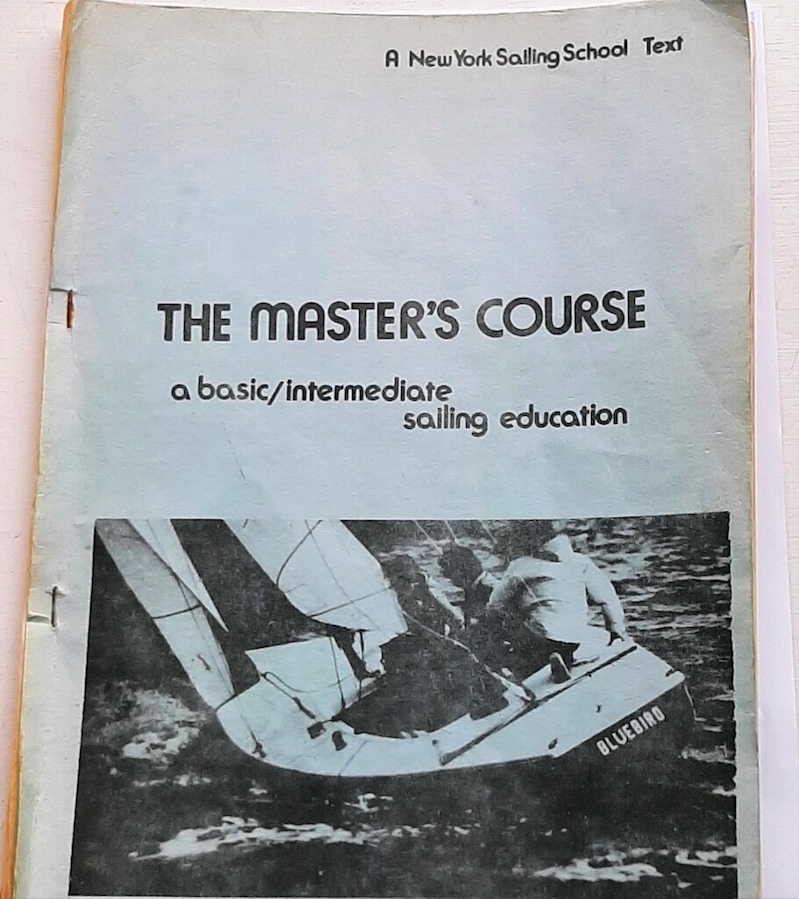
Learn-to-sail textbook authored by my father, Glenn F. Card, Jr, a Coast Guard licensed captain, for New York Sailing School which he founded in 1970 or earlier. This one’s from 1978, and the boat is the Olympic class Soling that was the most common boat used for adult sailing education in the US from the mid-’60’s through the ’70’s.
Above: his, not mine. Circa 1978, this was the text book students received when they signed up for The Master’s Course. This was the learn to sail/refresher course offered by New York Sailing School, which my dad founded in 1968 we believe. (It could have been ’70, but more likely ’68.) I was either 4 or 6 at the time!
The photo above was sent to me recently from a graduate of that program who is getting back into sailing after an absence. He learned to sail from my dad, and will continue on with me. We get this all the time; it’s one of the best feelings about being in the sport and the industry.
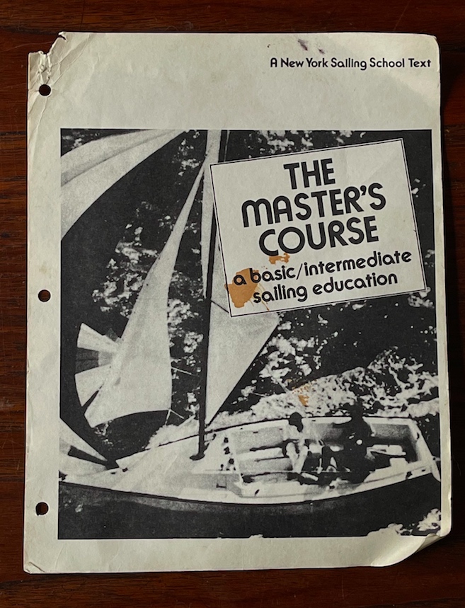
I can’t find a copy in our family’s stuff! I have the following cover from a slightly newer version of the same book…
The Master’s Course text, a few years younger than the one in the previous pic. On this cover is a Sonar, which we introduced to sailing instruction and were dealers for. It’s widely used to this day.
Before I continue, I’m calling on anyone who has a copy of this text book, regardless of which cover is on it, to get in touch with us! I have a scan of the contents but I want to get an original hard copy for sentimental reasons.
And, now, back to the Blog…
The textbook was low-tech and photocopied. It was either stapled together or 3-hole punched and bound. But, it worked: students found it simple, effective, fun, and a great resource. He wrote it because, well… he was a writer amongst other things. He did a lot of advertising copy-wrighting as part of his first career, becoming a Creative VP in several boutique firms from the Mad Men era (does the name Benton & Bowles ring a bell?). Eventually, his side hustle in sailing became all consuming and he launched New York Sailing School after more modest beginnings with rentals and what was perhaps the country’s earliest seasonal time-share/fractional sailing plan: Sail-A-Season.
He also wrote it as it was needed. The American Sailing Association (ASA) didn’t come around until 1983. That year, both my Glenn and I became ASA instructors: I’m # 830701, for those who get how those numbers work. US Sailing didn’t add a adult sailing school/instruction arm until 1993. So, there wasn’t an industry association text book series available. Yes, Colgate’s Basic Sailing Theory (Steve Colgate, Offshore Sailing School) existed. It was rather expensive and also written by the competition. And, I don’t think dad liked it on it’s merits, honestly.
Fast forward to 1986/87. Dad sold the school that winter while I was in college. He remained an advisor to them for a few years and I helped out with that. Gradually, they edited and changed the book until it wasn’t the Sh*t My Dad Wrote. End of era. Just after that, I wrote this, which I include not just to pat myself on the back but in the context of the geo-political climate of the times…
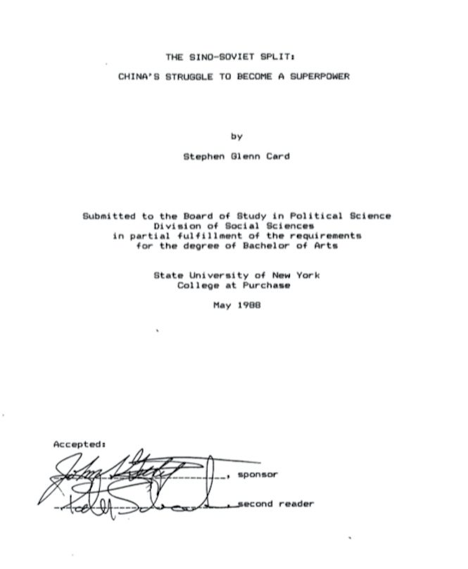
Stephen Glenn Card’s Senior Thesis at SUNY Purchase. Undergraduates had to submit substantial senior projects at Purchase. For those in the arts and music, it was quite literally a project. For those in the Liberal Arts, it was essentially a thesis. Mine was around 100 pages. Seniors had a thesis advisor and it had to be read and approved by a second faculty member in the department to be officially approved. A copy of each is professionally bound and maintained at the college’s library. My copy: went missing over the decades. But, they scanned the library’s copy and sent me the file! I’ll print and bind myself.
Dad passed of lung cancer in the summer of 1995.
Skip forward a few years to late summer of 1997. For various reasons, I started a new sailing school. I actually went into direct competition with the former family business. I had taken back management and operation of dad’s New York Sailing Center & Yacht Club the year before, which at the time was simply a small marina with mooring storage and launch service. When dad sold the sailing school, he didn’t see the marina. I simply added a sailing school to it. I started off by affiliating with US Sailing that year, and in the spring of ’98, also affiliated with ASA. New York Sailing Center & Yacht Club was one of only a handful of schools in the country to certify students through both organizations. Later, it came to be that no school could be an affiliate of both ASA and US Sailing for other boring reasons. (Schools can be affiliates of ASA and also organizational members of US Sailing, as we have been, but no school can offer both systems of certification.)
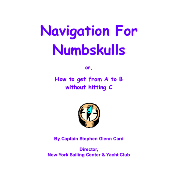
The author’s coastal navigation textbook, the companion to our ‘Live 105’ coastal nav courses on Zoom. Eventually, we hope to be offering them live in person again! Captain Card wrote the book in 2002. So… happy 20th!
Early on in the new school’s development, we started offering Start Navigating,SM the ASA 105 Coastal Navigation course. We had a consistent volume year round, offering it typically once a week for a month, 1x monthly. While ASA’s original textbook was excellent in many ways, it was missing material covered on the exam and also badly out of date on tech (RDF/Loran versus GPS). So, Captain Card (a/k/a Me, Myself and I) wrote a few short supplements to fill in those gaps. It was fun, but more needed to be done.
So, headphones on to the tune of “I, me, my” by The Beatles, he set to work one winter. During trips to Vermont for Thanksgiving and Christmas, he started drafting a comprehensive book. It sort of flowed organically, and it was fun, and it was good. So, whether it would ultimately be completed and used or not didn’t matter at the time. Over time, it became clear that ASA’s book wasn’t going to be revised anytime soon, despite them saying they’d send a draft of it soon.
Long story short: I finished my book and have used it for our Coastal Navigation course, Start Navigating,SM ever since. It’s had some minor updates over the years, but is essentially as written back in 2002. One topic needed revision when I stumbled in stages on something no one else did. The conventional wisdom about applying magnetic variation when plotting courses is misunderstood. It assumes something that isn’t true. I updated my book accordingly.
ASA? Nah. I was working with another ASA school owner on revising the answer key for the 105 exam. We agreed on the true courses for all the plotting problems, with one exception. After we both revisited this one, he ultimately agreed with my solution for it. However, we didn’t agree on the variation and therefore the magnetic course to use. (We address all this in the Start Navigating course, of course.) Upshot: I updated my book and he swept it under the rug.
In the meantime, ASA didn’t revise the first book. They introduced an entirely new one, to much self-generated fanfare. Later, they did in fact add a revised version of their first book. For awhile at least they continued to sell both. I never looked back. Neither did one of the authors, who didn’t update his book with the mathematical truth concerning magnetic variation. Not my problem; not my students’ either.
My book hasn’t been formally published. It did get its foot in the door at a major publishing house awhile ago: one of our former students was a literary agent and pitched it to an acquisition editor there. He caught it and re-pitched at an editorial meeting. They thought the book was worthy but not the sales projections and passed on it. So it goes…
But, Dad’s will be resurrected. I’m going to add things he didn’t include that now need to be there, and use it from that point forward for our Start Sailing course (ASA 101, learn-to-sail/Basic Keelboat).
“Shots and masks, masks and shots, and shots and masks!”
what George Carlin might have said about the state of things. I’m sure he’d have referenced those shots being in asses, too, but who knows.
COVID vaccination card for Mr. Card, on top of chart #13218, which we use in our ‘Live 105’ Zoom version of our Start Navigating course (ASA 105 Coastal Nav).
Two of our most prolific instructors have gotten their first shots now, and it’s all on the near term horizon for those who haven’t, so there’s that. Masks have become readily available, and it’s easier to find something that fits you. As warmer weather approaches, we soon transition from actually liking the masks on cold days to probably wishing they could come off on the warmer ones.
We’re still offering our “Live 105” coastal navigation courses on Zoom, but it’s transitioning soon to Sailing Club and courses.
Last season, we went through this with the masks. We started sailing in March! True, it was a private client here and there and group lessons began later this season. But, we had the whole spring-through-fall experience with them so can offer some thoughts.
Buffs and competing products are not so good for this. True, they offer good sun protection. But, they don’t work as well at filtering air, and they don’t shape around the nose. That means COVID in, COVID out. But, they can still be used as a neck gaitor. Just keep them down and put a proper mask on in their place, or put the buff over a proper mask if it’s not too tight.
Surgical masks: in our humble opinion, they suck! They are ill fitting and only good for blocking direct spray. They usually leave gaps on the cheeks and around the nose.
N-95 and K-95: depends on the fit. At least they’re white, so they don’t get as hot as anything dark. Obviously, the material has proper filtration. So, if they fit, and don’t leave gaps at the nose, you’re golden.
Cloth masks: good if they conform to the bridge of the nose. That requires a metal fitting that can pinch over the bridge. No got? No use.
Mask on left: from Ski The East. (mask on right of unknown origin)
Cloth or other fabric with an inner pocket for disposable filters: these are the ultimate in our opinion, as long as the filter used is good in filtration and fit. I found a style from Ski The East that have more breathable fabric – tighter weave on the outside, and the inside layer is a little too breathable. But, there’s a large inner pocket for a filter, and a large seam that goes around the edge of the chin and jaw. The filter area starts there and goes up to the nose clip. Strangely, they supply a filter that doesnt’ fill the space and is too small. But, if you get packs of filters from another source that fit the area, you get comfortable masks that can fit properly and balance breathability with protection.
They come with elastic ear pieces that are adjustable, and one can tighten the top and bottom independently or together to customize the fit.
I liked my first pair so much I bought two more. I even used it snowboarding: I put it on, then put my balaclava helmet liner on around it and keep the face part down. I now need to re-order filters. I found ones at REI that are for an Outdoor Research mask product that I do not recommend (Adrenaline Sports Face Mask), having tried it as well as observing another masker’s successes and failures with it, but the filters will fit the Ski the East masks and probably many others of similar style. See links below.
Why worry about this when outdoors? Well, remember the Rose Garden super spreader event? remember there’s this thing called wind? It’s when the air blows – sometimes your way? Yeah. Being outdoors is better.. until it isn’t. Indoors, with proper ventilation and filtration, can be better (although it usually isn’t). One of our clients is a Delta pilot and says he feels far safer in the confines of a plane than in any other indoor scenario, given the turnaround time on filtering air: every 3 to 4 minutes!
And more about air travel, versus driving: some experts are going out on a wing and saying it’s MUCH safer. And, we’re talking Covid context. Here you go…
Pandemic living has some interesting scenarios for learning how to navigate or sail on Zoom.
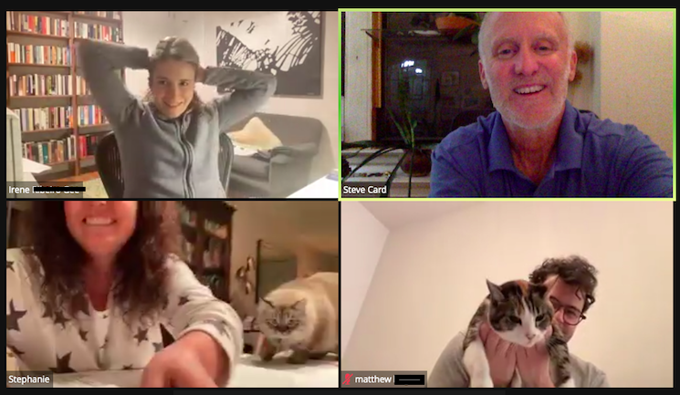
“The Cat ate my homework” starts to sound reasonable! While I haven’t heard that (or by dog) from a student in our “Live 105” Coastal Navigation courses on Zoom, I’ve seen some strange stuff. Strange is purely subjective and relative, of course.
No; he didn’t eat the homework. But he got in her way…
First: what’s this course? It’s our Start Navigating course, ASA 105 Coastal Navigation. It has no prerequisites, and no prior navigation experience or training is necessary. (It is helpful to have done some boating or sailing for better perspective, but we assume none of that when we teach you.)
PC (Pre COVID), we taught this in small group settings both in Manhattan and New Rochelle. Last March, we switched to Zoom: the first school doing it, and the only one I can actually verify as doing so. It’s gone quite well! It’s almost as if we’re all in the same room together, and allows people in different locations and time zones to navigate together and make new friends and potential sailing buddies.
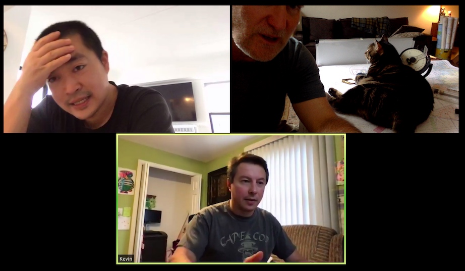
Anywho, as most people are doing this from home, we get a glimpse of what home looks, sounds and feels like. That includes critters.
CRITTERS: cats in the two right-hand windows on this Nav Zoom. The couple also has a dog that pops up from time to time.
So far, we haven’t seen the proverbial pirate parrot perched on anyone’s shoulder, or carrying off plotting tools as a prank, but a number of cats and dogs have scored some screen shots.
I host and teach all our Zoom sessions. It comes naturally to me, and is fitting as I wrote the book we use for the course. Why not use the ASA book? That’s a loooong story, but short version: got tired of waiting for them to revise and professionally print their very good old book. Had to write supplements for it for topics covered on exam but not in book, for example. Started drafting my own. Almost done; needed a few final copies for first course of a winter season. They gone went and published an entirely new book by another author rather than revise the old one, and instead of the expensive price going down, it actually went UP further. But wait – there’s more! They also had a separate companion book that wasn’t just practice problems or resources, but also part of the text.
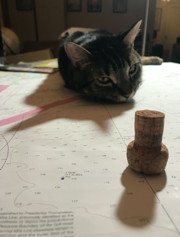
PELORUS CONFUSEUS: cat interfering with deployment of a pelorus, to his right. A pelorus is a sighting and direction measuring tool that’s somewhat antiquated, but also important for understanding how to use radar. So, we demonstrate its use in Start Navigating! ASA’s curriculum chumped out on that and dropped it. We didn’t.
But wait – there’s MORE!!! There was also a companion DVD . Took a look at that for about 30 seconds, couldn’t take it any more. Tossed it like a frisbee for the cat who pounced on it. Never saw it again. (Ultimately, after breaking their own arm patting themselves on the back for this rollout, they gone went and did what they said they were originally: revised the OLD one. And, they published that as well, offering both texts. At that point, I’d been using my own for a few years, and have simply tweaked that and never looked back.)
So, cats, and dogs. Here’s one pic in an Instagram post from a live class, PC of course. The pic is a link…
Awwww….. so sad…. This is Jude! He’s a big, clingy baby. This shot is ‘PC,’ so I was working live with a couple in a custom private schedule. it’s one of three in an Instagram post; click pic to see!
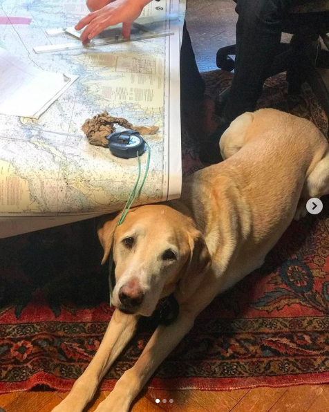
My cat attends each Zoom session. He interferes while lounging across the chart, or gets annoyed if he senses I’m paying him no mind and talking to a computer screen that is talking back. Then, he gets very intrusive and has to be escorted out.
This is Buddy! He’s a pain… but can be sweet at times as well. He’s named after an indoor/outdoor cat who came to visit most days one summer by strolling into the Sailing Center’s yard and hanging with us for awhile. Then, he didn’t. That’s cat behavior for you!
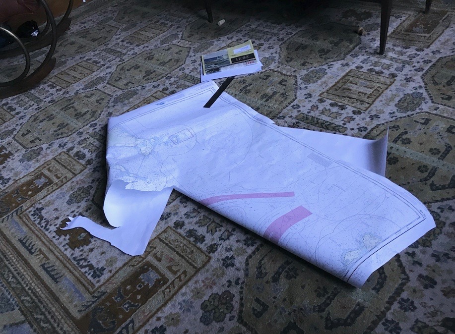
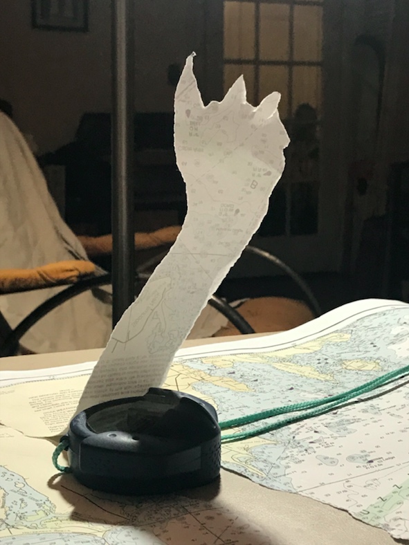
Just before our most recent session, I had the chart spread out to review one of the practice plots. Buddy jumped up on it, but it was draped over the side of the coffee table, and he didn’t land cleanly on the table. So, the slash-n-scramble routine ensued. End result: I needed oxygen and the chart looked like this:
BUT WAIT – there’s MORE!… It’s like an actual cartoon, where the Warner Bros’ Looney Tune tears ass through a wall leaving the outline…
I taped up the chart for the class, as I needed one specific plot that’s on it. This seemed like a fun thing to do with the hand-held ‘hockey-puck’ compass at the time.
Pets are optional, of course, for this course. But if you’re managing work, family/kids, or those perpetual 2 year-olds… pets… bring it! It’s all manageable on Zoom.
For more about our “Live 105” sessions on Zoom for Start Navigating, here you go…
We’re not out of COVID country yet, so protect and then play.
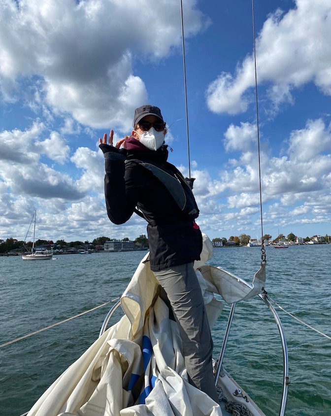
IN THAT PIC: Melody, Sunday, October 18, during a Start Cruising course (ASA 103). She did 101 with us this season as well!
It’s been a strange season, but as usual, we improvise, adapt and overcome. In March, we didn’t know if we’d have a sailing season at the Sailing Center! By June, we knew it would be closer to biz as usual on the water, in addition to our innovative and popular “Live 105” courses on Zoom for Coastal Nav (which no one else seems to be running). We figured we just had to play it safe.
We did. We limited class sizes beyond (below?) our normal capacities, further reduced classroom time for learn to sail courses, and mandated masks. Sometimes, people could take them off, but only when it made sense. Most people arrived at the Sailing Center pre-conditioned to wearing their masks all the time. (One or two prospective students were not invited to sign up after expressing a distaste or unwillingness to wear masks.)
Video clip for ya ! Mike and Kelly “deal with the heel” on a windy day…
We got through the season, which is winding down. It ends by early November for us. But, the country, and much of the world, is NOT through the pandemic. Politics aside, numbers don’t lie. People lying in ICU beds in hospitals are not faking it. Many countries are in their second or third waves or spikes, and winter is coming which will almost certainly make the pandemic worse. (And don’t forget the flu!!!) A COVID-19 vaccine is not immediately around the corner, nor is worldwide distribution of it when it arrives. So… wear that mask!
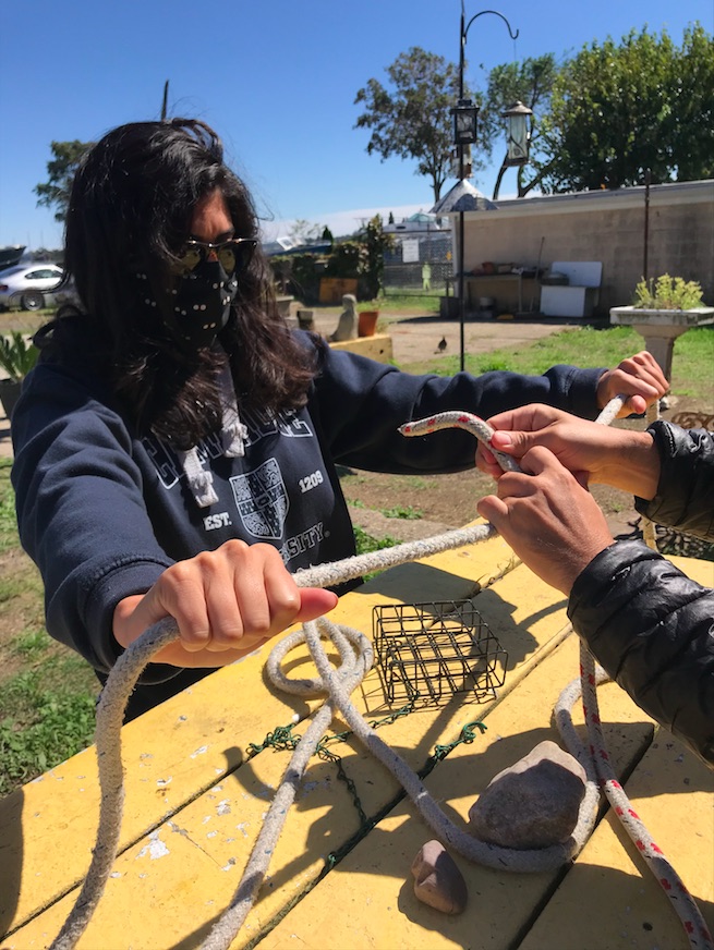
IN THAT PIC: Laura, behind all that mask and hair, joining two lines with a rolling hitch in tandem with Chris’ hands. Start Sailing, ASA 101, in September.
So…. it’s not over ’til it’s over. That sadly applies to the pandemic, but I’ll gladly take that this sailing season isn’t quite over and despite that, and eager anticipation of sliding down snow, we’re already looking forward to the next one!
Scientists struggle to model the movement of the magnetic north pole. In our live, online ASA 105 coastal navigation course, a real instructor teaches you about this, and why you can basically ignore it.
We’re having a lot of fun with our “Live 105” classes on Zoom! Real instructor, real time, real students – in the same, small manageable class sizes we have for in-person courses. One of our current students sent a link to a BBC article related to the content of a 105 course, which is of course all about…
COASTAL NAVIGATION.
The link Cristina sent? A BBC piece about the movement, or wandering, of the magnetic north pole. We link to the piece at the end of this Rant. For now…
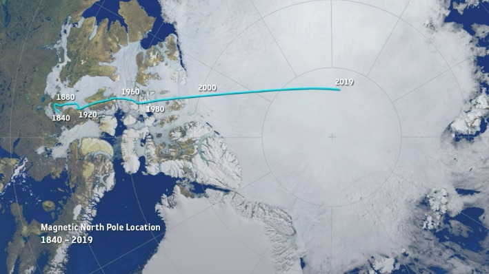
In that pic: the thin aqua line traces the approximate motion of the magnetic north pole from 1840 to 2019. It’s accelerated recently, creating a scientific buzz. (Pic is a still frame from a video in the BBC piece we link to below.)
THE IDEA: the magnetism of earth is both consistent and inconsistent. Compasses point to the same place on earth with minor wiggles. This is close to the geographic north pole, or the rotational axis of earth. If Atlas stopped shrugging, and spun earth on the tip of his finger like a Harlem Globetrotter, it would be on the South Pole, with the North Pole exactly at the other end – or “top.” But, “top” is arbitrary, ain’t it? Space has no direction. We’re floating in space. And, what’s more…
It might flip! Yup. Magnetic North and South have reversed from time to time. Maybe every few hundred thousand years. The question is whether this could happen within our lifetimes. And, partially due to accelerated movement of the Mag North Pole, scientists suspect it might.
1, 2, 3… SWITCH! Oops…
THE ARTICLE’S PATH: Scientists studying this have noted the acceleration of the drift of the Mag North Pole recently, and have updated the global model used for that as it relates to GPS, which is critical to precise navigation. That’s not always super critical itself; as we teach in Start Navigating ( ASA 105), it’s almost more important to check progress in real time than plan the path perfectly to begin with. Basically, they think they’ve identified two molten “hot spots” in the earth’s outer core that are having a tug of war over the magnetic north pole. Kewl! Or, very hot…
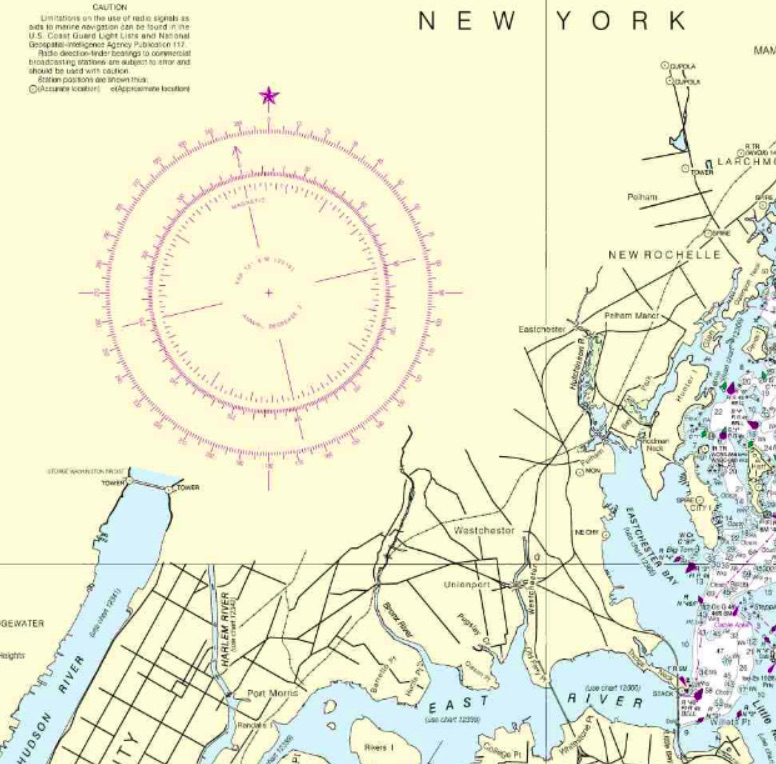
That gets into some chart nitty-gritty: the compass rose. It’s a tool to measure direction, and it looks pretty kewl too. Check it…
In that pic: a section of the 12363 chart of Western Long Island Sound, with City Island (“City I”) on the right, which is home to the Sailing Center. It’s about half the length of Manhattan away from it; northern MannyHanny is on the bottom left of the chart. It has a nice, large compass rose, or rings that measure direction. The outer ring is for true, or geographic, north – with a star at the top for Polaris, the actual North Star. The inner ring is for magnetic north, which is where compasses point more or less. In navigation classes, we teach how to use these to plot out a course to steer a boat.
THE CONVENTIONAL WISDOM: look at the annual increase/decrease in the variation as listed in rose (the pic below blows it up for you). It’s usually a few “minutes” a year. Each minute = ..? It’s a measly 1/60th of 1 degree of the compass. Yup; slicing hairs with razor blades. Anywho… if your chart is out of date, the idea is to multiply the number of years of ‘stale’ by the number of minutes of change, and add or subtract accordingly. And, get the +/- right!
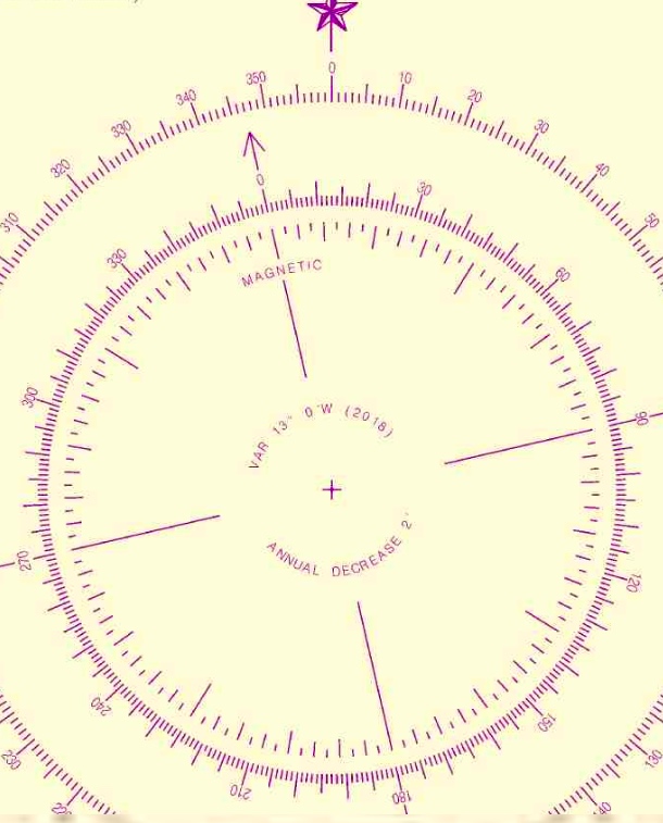
ABOVE: blown-up crop of the compass rose from the same chart above. Variation: 13 degrees West as of 2016. Annual decrease: 2 minutes (2 out of 60, with each compass degree having 60!). Splitting hairs…
NYSC knows better… our Director and HBIC (Head Bozo in Charge), Captain Card, had a suspicion about something years ago. He compared every training chart the government produced, which are all frozen in time going back a far as the early 1980’s, to the updated, real-life versions of those charts. The conclusion? It’s silly to try to project any annual increase or decrease into the future. We expand on that and reveal the goods in class, and in our own in-house text book that we supply to students (and sell on the side). Despite what other books say, just skip this step. Much smarter move: get a current chart, for all the more obvious reasons.
Maybe we’ll be lucky (?) enough to see the poles flip in our lifetimes! Will planes drop from the sky, and cars run off the roads? Well, if they can’t figure that their GPS and compasses are basically pointing backward, we can’t help them.
Your takeaway? Use updated charts to plot courses to your destinations, and casually follow along with the progress of Mag North Pole’s wanderings across cold areas most of us will never visit.
We’re rolling live with Zoom! Our interactive on-line Start Navigating courses (ASA 105, Coastal Navigation) are officially a hit. They have 100% social distance, are fun, and as if we’re right there with you.
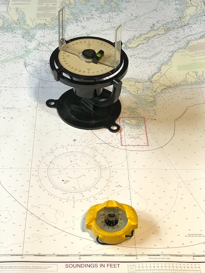
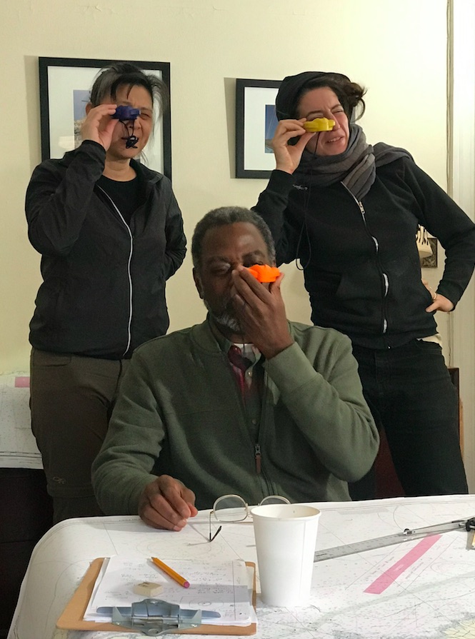
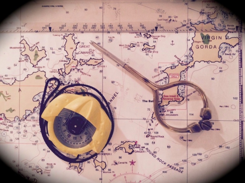
(…but, of course, we’re NOT.) IN THAT PIC: Two tools! Err… instruments. ‘North:’ a pelorus we recently scored on eBay. They’re antiquated to obsolescent, but still critical to understanding radar. ‘South:’ hand-bearing compass, or “hockey puck.” Critical to taking bearings for proof of position on the water… and dealing with deviation on the boat’s steering compass! Yup. We teach you how to use both.
Students have been tending to sign up in groups for some reason. No problem! One group and done, and always room for singles and pairs. Some people are arranging social study-sessions in between classes to do some of the practice plotting together.
How does it work?
You sign up. Imagine the Bobble Head version of Ray Liotta in “Goodfellas,” when he’s describing all the excuses people give when his character would go on his collection rounds. Any excuse… his answer’s the same: “F&%$ YOU PAY ME! F#@$ YOU PAY ME! F%*$ YOU PAY ME!” (Parenthetical aside, our Director and HBIC, Captain Card, who runs the Zooms sessions by the way, went to College with someone who was an extra in the movie and got listed in the cast. “Bar Patron.” If you have enough time on your hands, and send us his name, you get $25 off the course!)
We send you the materials: chart, plotting tool, and dividers (nautical drafting compass). We also email the text book in advance as a PDF, although there’s no reading or other prep required. You might want to, however: our Director wrote it. It’s fun, easy to read, well illustrated with photos, color, and step-by-step diagrams. And, it’s effective.
You log on with the invitation before class starts, and BOOM. ZOOM!! You’re learning live, and laughing too.
IN THAT PIC: Real-life, real-time. And, it was recent! From our Feb/March trip in the BVI (Virgin Islands). We were heading back to the main island chain from Anegada, barely visible top right. Anegada is barely above sea level, and can’t be seen from the rest of the BVI – not until almost half way across the passage to it! Critical to get it right… it’s surrounded by coral reefs except for a very small approach that must be made at the one safe angle. Or… boom. Aground and unhappy. We often use the example of plotting the passage to Anegada in our Start Navigating course.
“What exactly is this course, anyway? “ It’s all about how to navigate a boat for day trips, overnights, and even extended cruises along a coast. You can even lose sight of land for awhile. Soup to nuts: you’ll be able to navigate in pea-soup fog once you’ve practiced on the water for awhile in more sane conditions.
“Who can take it?” Anyone who wants to learn. It’s great for getting stoked / psyched about going boating and sailing. No, there’s no experience or prior study or training required. It’s helpful to have done some boating for perspective but that’s about it.
“Who SHOULD take it?” Anyone who’s intrigued about boating and sailing, and wants to get a flavor of things to come right NOW. Even if you don’t yet sail. If taking this course now doesn’t compete with time or funds for more important things, just do it. If you plan to eventually do longer day sails, and/or overnight trips, especially chartering for a week abroad, then DEF do it. If you already sail, but have no short or mid-term plans to do anything more involved than you already do, then you’re fine skipping this course for now or maybe forever (unless you’re currently having trouble finding your way around). But, it’s fun… and might jump start the next phase of your sailing career.
“What’s covered in this course?” Everything from… “this is a chart. We call it a chart, not a map. That’s for landlubbers!” to… proving position underway, compass deviation, proving what the current did to push you off course and fixing that going forward.
Very importantly even for day sailors, we break down the misleading oversimplification that is called “Red, Right, Returning” and prove what that’s “wRong!” Yup. We just said that; you just read that. It’s total BS, and we’ll prove it to you.
IN THAT PIC:From less socially distant times… early winter 2019, Manhattan: Start Navigating course. Of course, we had a surplus of hockey-puck compasses to play with that day as one sailor brought one from home! Yup – even with the on-line course, we can teach you how to handle the hockey puck.
“How is the scheduling done?” If you’re a group of two or more, THAT’S a schedule (unless of course it conflicts with one in progress). Joining alone? No problem. We’ll discuss what’s in the queue now, and if that doesn’t work, we’ll create another schedule. We don’t have to set the entire schedule in advance either.
The course takes 3-5 sessions to complete depending on how long each one is, and how quickly people pick up what we’re putting down. Sessions are typically between 2.5 and 3 hours with a break. We can do them any time of the day or evening, any day of the week, subject to existing obligations. (We are, of course, readying our fleet, with two boats in the water so far, and doing very limited on-water activities.)
“What does it cost? What’s included?”$275, which is $120 less than our normal full tuition for in-person courses. It’s all-inclusive: materials, tools, and certification.
“How do I pull the trigger?” Here are some links: one for the Start Navigating 105 page to learn more about the course, and one for just signing up. Feel free to call or write with any questions first; here’s how to hit us up.
What would Newton do? (In a modern day pandemic.) Well, he actually did it, if one considers London’s Great Plague of 1665-66 modern enough. He did several things in fact.
Isaac Newton, eventually Sir Isaac, basically quarantined himself during this catastrophe, having recently completed undergraduate studies at the ripe old age of 23. He, like all privileged Londoners at the time, fled the city. At his family’s countryside retreat, he was a busy boy! What did he do that was relevant to navigation?
Newton, with some social distance from an apparently alarmed observer, as he experiments with prisms to understand the composition of light. Image shamelessly copped from stock.)
Well, truth be told, that’s a stretch – but we do need to stretch our imaginations to keep ourselves occupied during our social distancing and quarantining. We’ll try to get there. First, here is what Newton did with his time:
He studied gravity. Yep; that apple crap. This led to his eventual creation of the laws of motion and his career-defining work, Principia.
He started working on optics, proving that “white” light consisted of the complete color spectrum using a pair of prisms;
He picked up where Descartes and de Fermat left off with universal equations of fluctuating quantities, solving that dilemma with a series of papers and formalizing what we now call Calculus!
That was Newton. And that was then. And now, we have to find things to do and learn while keeping social distance and isolating. One option: Start Navigating SM: ASA Coastal Navigation (105). But we have to do it with social distance. So, we have to do it from home via Zoom, FaceTime, etc. That’s the Staples part (where we get some of our 105 supplies); that’s easy.
But what about the math? Newton did some complex math during his tenure away from town. How much math is involved with Coastal Navigation? That depends on who you learn it from. It can be fairly complicated – or, you can do it our way:
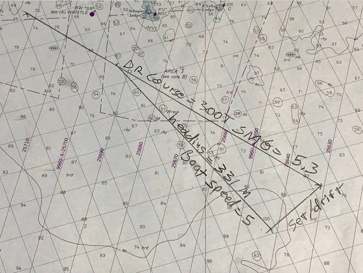
Plot the path without the math!
Path; no math. No arithmetic or math used to plot this set & drift ‘triangle.’ The geometry is built in. This is our preferred method. Cuz, you know… trig sucks on a boat! 1210 Tr chart (training; not updated), Block Island to Martha’s Vineyard. This is the solution to a practice plot submitted to us to refresh a memory on this technique.
We use as little math as possible when doing – and teaching – navigation. We teach the little bit of algebra needed for deduced, or ‘dead,’ reckoning, and we make it easy with a visual aid that’s intuitive to use. We refresh peeps on their long-hand division when they forget how. Can’t rely on a calculator on the water. But for the serious stuff? Set and drift of current while underway with no current tables to consult?
That’s where we plot the path without the math. Not even basic arithmetic. Just draw lines based on the concept, representing what the boat and the current do, and measure the final answer: course to steer! We even give you some toys to play with in the process…
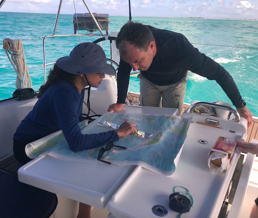
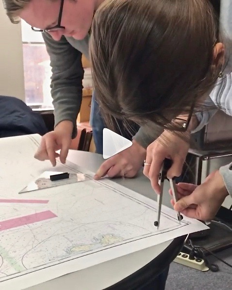
People plotting in one of our Start NavigatingSM courses this past winter. Pre-Corona. He’s working with a triangular protractor, or plotting tool. She’s manipulating the world’s finest one-handed dividers. Yes; she’s using two hands. Sometimes that’s helpful to set one point quickly and accurately. Then one rocks ’em with one hand! All being done on a real chart, not a training chart frozen in time to the 1980’s with incorrect coloring and needless extra clutter.
Here’s how it works – think of it as a sample of the 105 Nav course. Yes, it’s an advanced topic; no, there will be no quiz to you as the reader afterward, and I’m sure you can follow along!..
Step 1: Draw a line from “point A” to “point B.” That’s the path you want to sail. It’s like drawing your own road on a map; your only job after that is to stay on it. In the chart pic above, it’s the top line labeled “DR Course” (not A to B, but think of it that way).
Step 2: Now, draw a line from point A showing the path the current will flow. How do you know? Let’s just assume you knew how to look it up and find its speed and direction. (Yes, we teach you all that in the course.) Draw it in that direction, for the distance it moves in one hour. Tool used? Any straight edge such as a ruler, or the nautical plotting tool we send you in advance! Distance? Use the dividers, or nautical drafting compass, to mark this. (No math – we promise!) In the chart pic, it’s the bottom right line labeled “Set/Drift.” So, for example, if the current is 2 knots, set the dividers to 2 nautical miles – the distance it flows in one hour.
That shows were your boat will be if you just let it drift helplessly from point A for one hour. We don’t want that, do we? Of course not! So, we have to figure out how much to offset our course to fight the current and stay on our intended track. How?
Step 3: Figure out the boat’s speed in knots (nautical mph). Then, we set the dividers to that speed. How? Same as with the current in step 2 above. It’s all based on one hour: an hour of the current’s motion, and an hour of sailing (or motoring) while in that current.
Step 4: Now, set one point of the compass/divider on the spot where the current line ends. Swing the other end over to the DR, or nautical road map line, you drew from A to B. Set the point down; draw in that line. In the pic, that’s the third leg of the triangle formed, labeled “heading” and “boat speed.”
Step 5:Boom. That line is also the angle to steer by the boat’s compass to fight the current! Measure that with your plotting tool. Steer that when you sail, and you’re on track to point B.
Is it slightly more complicated than that in real life? No… but you do need to work up to it by starting with more basic info and practice, and then the steps above are very straightforward… just like your boat’s trajectory over ground in real life/real time to arrive at your point B!
And, yes – we can teach this to you live and interactively. We’ll do that for now; eventually, we’ll be cleared for takeoff on taking off the masks, cutting the social distance, and resuming life as normal as it gets post-pandemic. In the meantime, if Newton played with prisms, here is a prism for you to ponder navigationally…
Remember the porrtait of Newton playing with prisms? No? It’s literally at the top of… Nevermind. Here’s a hand-held compass that’s one of the most popular models in use. It uses a prism! The funny metal thing on the right is a fancy-lad pair of dividers. Elegant but not as practical as the ones shown above. We teach you how to use a hand-held compass like this in the course.