What would Newton do? (In a modern day pandemic.) Well, he actually did it, if one considers London’s Great Plague of 1665-66 modern enough. He did several things in fact.
Isaac Newton, eventually Sir Isaac, basically quarantined himself during this catastrophe, having recently completed undergraduate studies at the ripe old age of 23. He, like all privileged Londoners at the time, fled the city. At his family’s countryside retreat, he was a busy boy! What did he do that was relevant to navigation?
Well, truth be told, that’s a stretch – but we do need to stretch our imaginations to keep ourselves occupied during our social distancing and quarantining. We’ll try to get there. First, here is what Newton did with his time:
- He studied gravity. Yep; that apple crap. This led to his eventual creation of the laws of motion and his career-defining work, Principia.
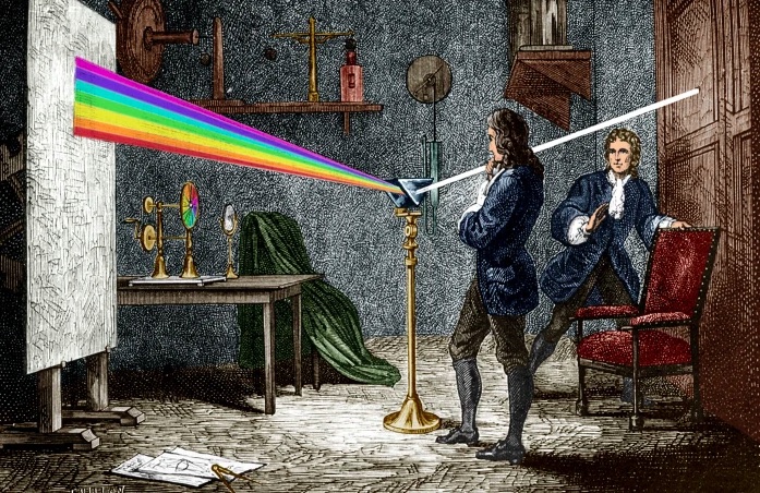
- He started working on optics, proving that “white” light consisted of the complete color spectrum using a pair of prisms;
- He picked up where Descartes and de Fermat left off with universal equations of fluctuating quantities, solving that dilemma with a series of papers and formalizing what we now call Calculus!
That was Newton. And that was then. And now, we have to find things to do and learn while keeping social distance and isolating. One option: Start Navigating SM: ASA Coastal Navigation (105). But we have to do it with social distance. So, we have to do it from home via Zoom, FaceTime, etc. That’s the Staples part (where we get some of our 105 supplies); that’s easy.
But what about the math? Newton did some complex math during his tenure away from town. How much math is involved with Coastal Navigation? That depends on who you learn it from. It can be fairly complicated – or, you can do it our way:
Plot the path without the math!
We use as little math as possible when doing – and teaching – navigation. We teach the little bit of algebra needed for deduced, or ‘dead,’ reckoning, and we make it easy with a visual aid that’s intuitive to use. We refresh peeps on their long-hand division when they forget how. Can’t rely on a calculator on the water. But for the serious stuff? Set and drift of current while underway with no current tables to consult?
That’s where we plot the path without the math. Not even basic arithmetic. Just draw lines based on the concept, representing what the boat and the current do, and measure the final answer: course to steer! We even give you some toys to play with in the process…
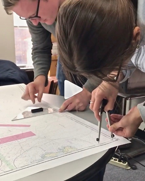
Here’s how it works – think of it as a sample of the 105 Nav course. Yes, it’s an advanced topic; no, there will be no quiz to you as the reader afterward, and I’m sure you can follow along!..
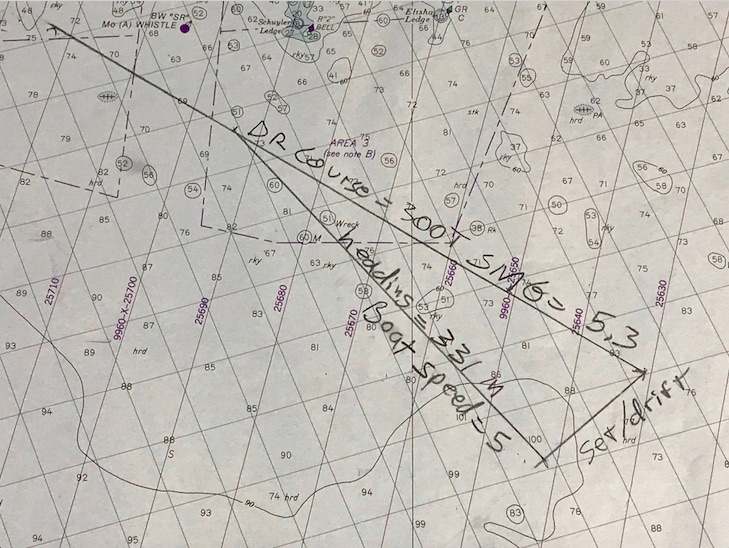
Step 1: Draw a line from “point A” to “point B.” That’s the path you want to sail. It’s like drawing your own road on a map; your only job after that is to stay on it. In the chart pic above, it’s the top line labeled “DR Course” (not A to B, but think of it that way).
Step 2: Now, draw a line from point A showing the path the current will flow. How do you know? Let’s just assume you knew how to look it up and find its speed and direction. (Yes, we teach you all that in the course.) Draw it in that direction, for the distance it moves in one hour. Tool used? Any straight edge such as a ruler, or the nautical plotting tool we send you in advance! Distance? Use the dividers, or nautical drafting compass, to mark this. (No math – we promise!) In the chart pic, it’s the bottom right line labeled “Set/Drift.” So, for example, if the current is 2 knots, set the dividers to 2 nautical miles – the distance it flows in one hour.
That shows were your boat will be if you just let it drift helplessly from point A for one hour. We don’t want that, do we? Of course not! So, we have to figure out how much to offset our course to fight the current and stay on our intended track. How?
Step 3: Figure out the boat’s speed in knots (nautical mph). Then, we set the dividers to that speed. How? Same as with the current in step 2 above. It’s all based on one hour: an hour of the current’s motion, and an hour of sailing (or motoring) while in that current.
Step 4: Now, set one point of the compass/divider on the spot where the current line ends. Swing the other end over to the DR, or nautical road map line, you drew from A to B. Set the point down; draw in that line. In the pic, that’s the third leg of the triangle formed, labeled “heading” and “boat speed.”
Step 5: Boom. That line is also the angle to steer by the boat’s compass to fight the current! Measure that with your plotting tool. Steer that when you sail, and you’re on track to point B.
Is it slightly more complicated than that in real life? No… but you do need to work up to it by starting with more basic info and practice, and then the steps above are very straightforward… just like your boat’s trajectory over ground in real life/real time to arrive at your point B!
And, yes – we can teach this to you live and interactively. We’ll do that for now; eventually, we’ll be cleared for takeoff on taking off the masks, cutting the social distance, and resuming life as normal as it gets post-pandemic. In the meantime, if Newton played with prisms, here is a prism for you to ponder navigationally…
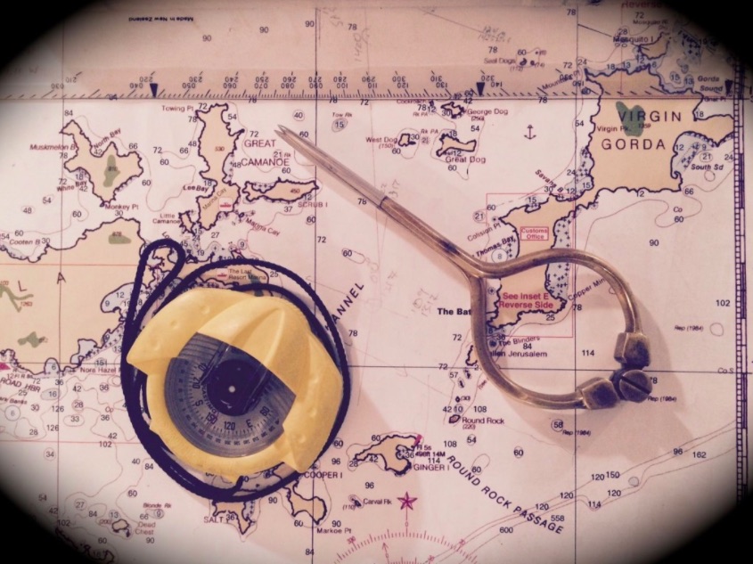
Nevermind. Here’s a hand-held compass that’s one of the most popular models in use. It uses a prism! The funny metal thing on the right is a fancy-lad pair of dividers. Elegant but not as practical as the ones shown above. We teach you how to use a hand-held compass like this in the course.
For a nice piece about one author’s current state of isolation in the context of annus mirabilis, or year of miracles (yup, that’s what they called Newton’s time), here you go… https://www.washingtonpost.com/opinions/2020/03/20/newton-formulated-his-theory-gravity-time-plague-we-need-miracle-too/
For a bit more context and detail on Newton’s topics above, check out this one… https://www.biography.com/news/isaac-newton-quarantine-plague-discoveries
And, finally… for more about finding your path on the water, and our on-line navigation course, see our Coastal Nav page here…