Missed the boat this season? You can book NOW to learn how to sail a boat next spring or summer.
We’ve posted the 2025 learn-to-sail schedules, and earlier than we ever have. Why? Demand exceeds our supply, and the early-season schedules fill up early. How early? Now. Fall of and early winter (think January) see all the early choices taken for the coming season. So, if you can book now, or simply prefer to plan well in advance, now’s the time.
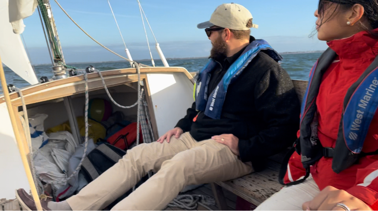
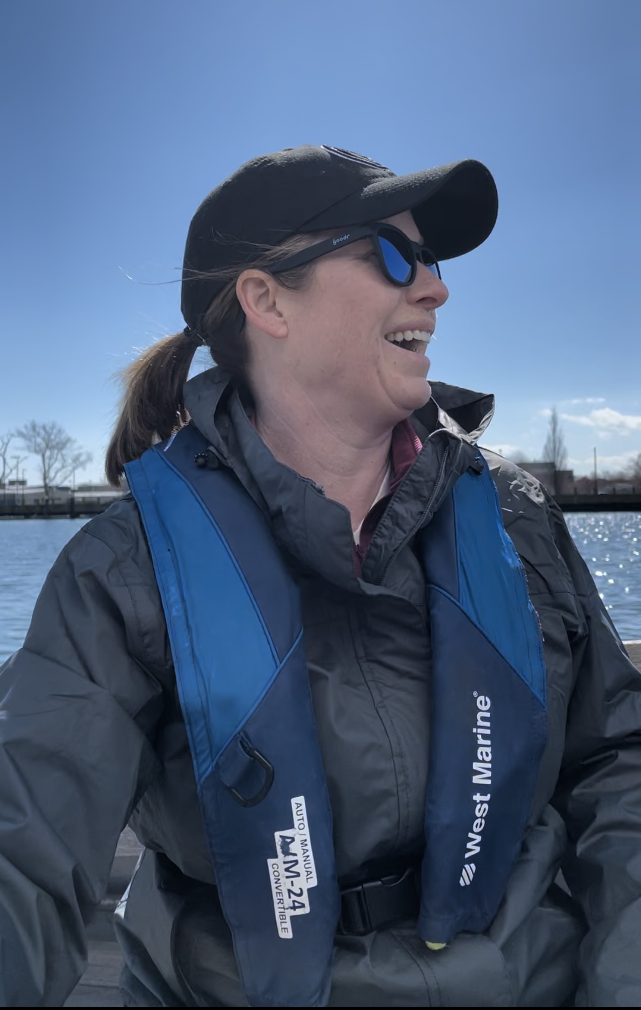
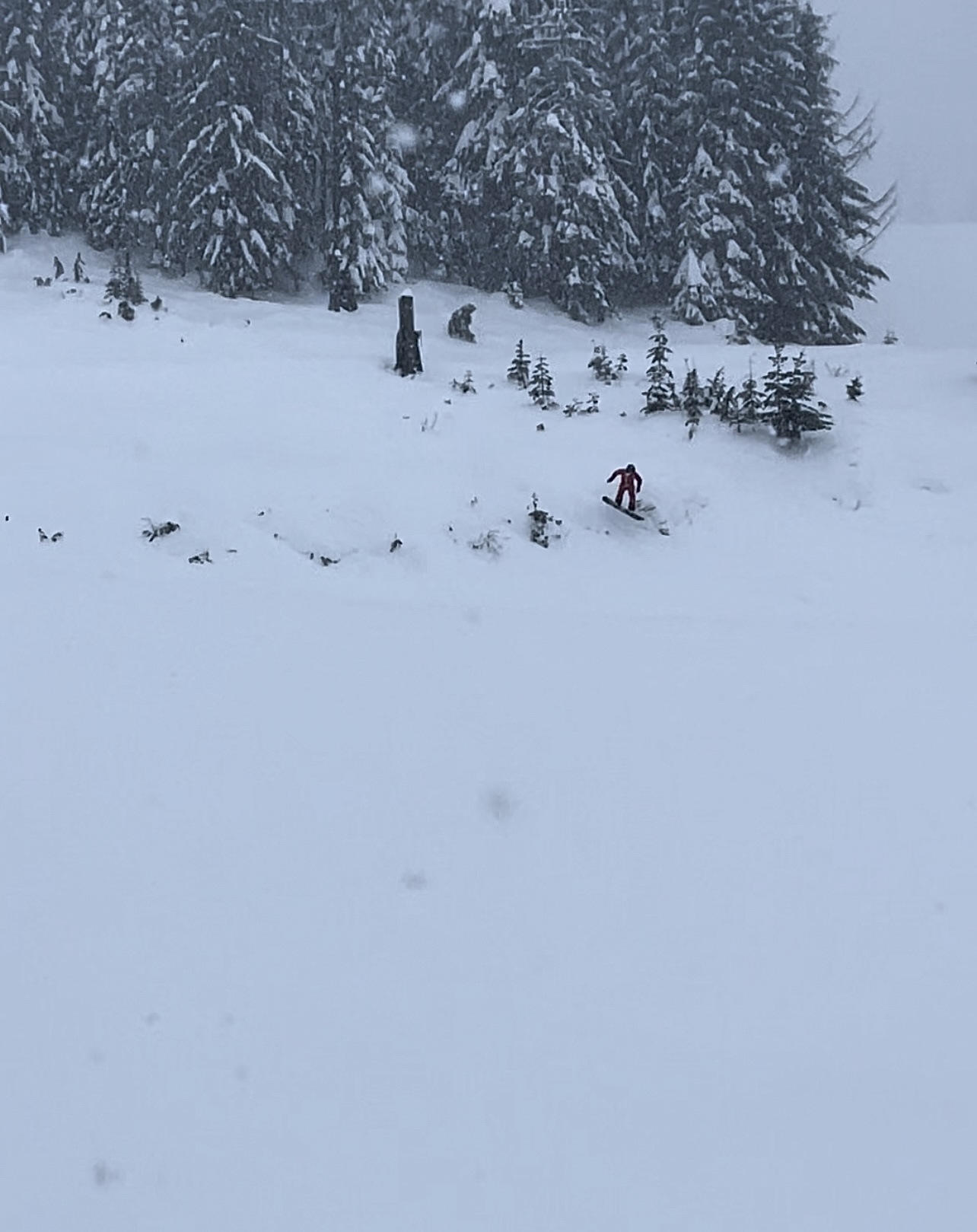
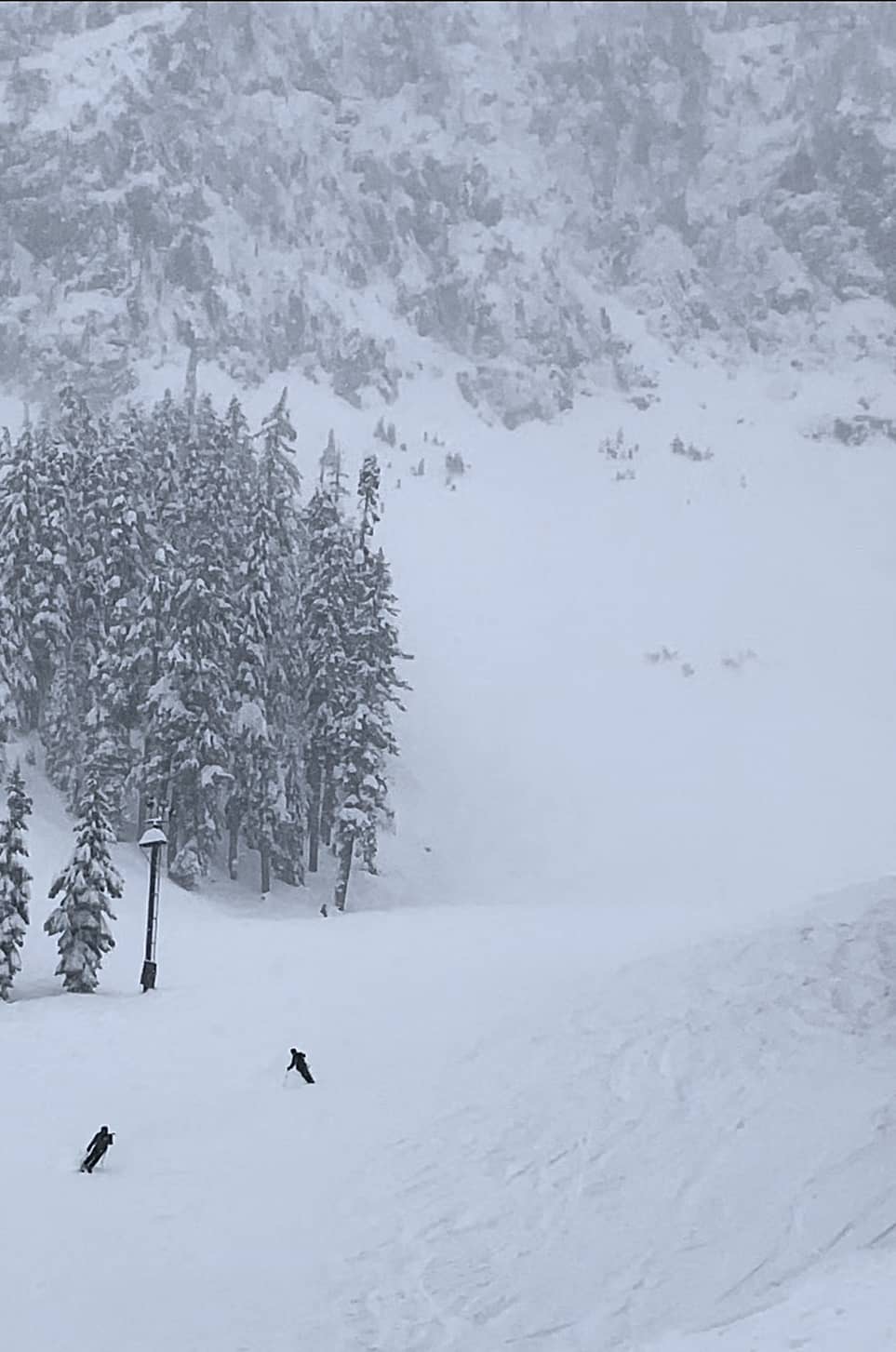
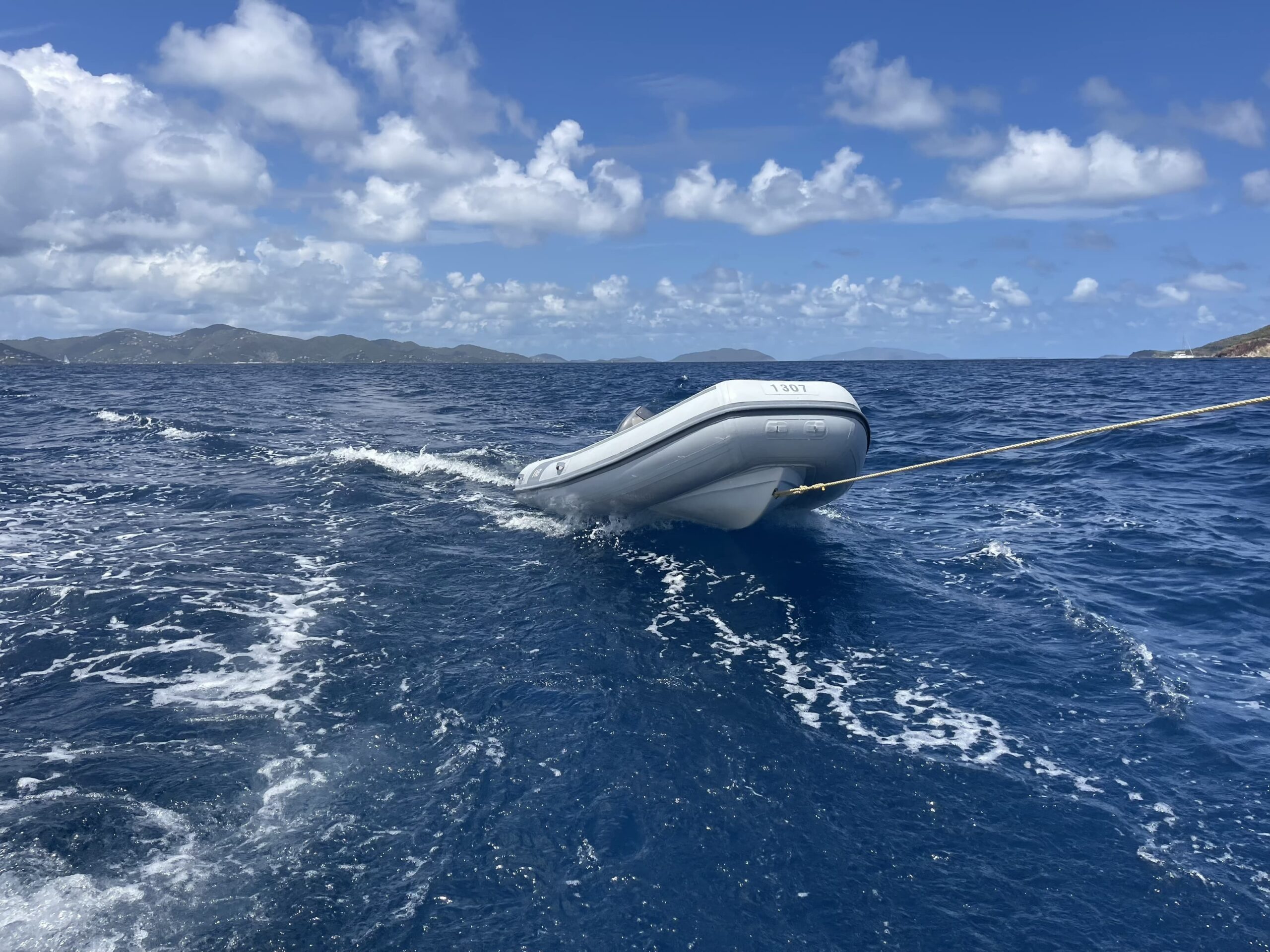
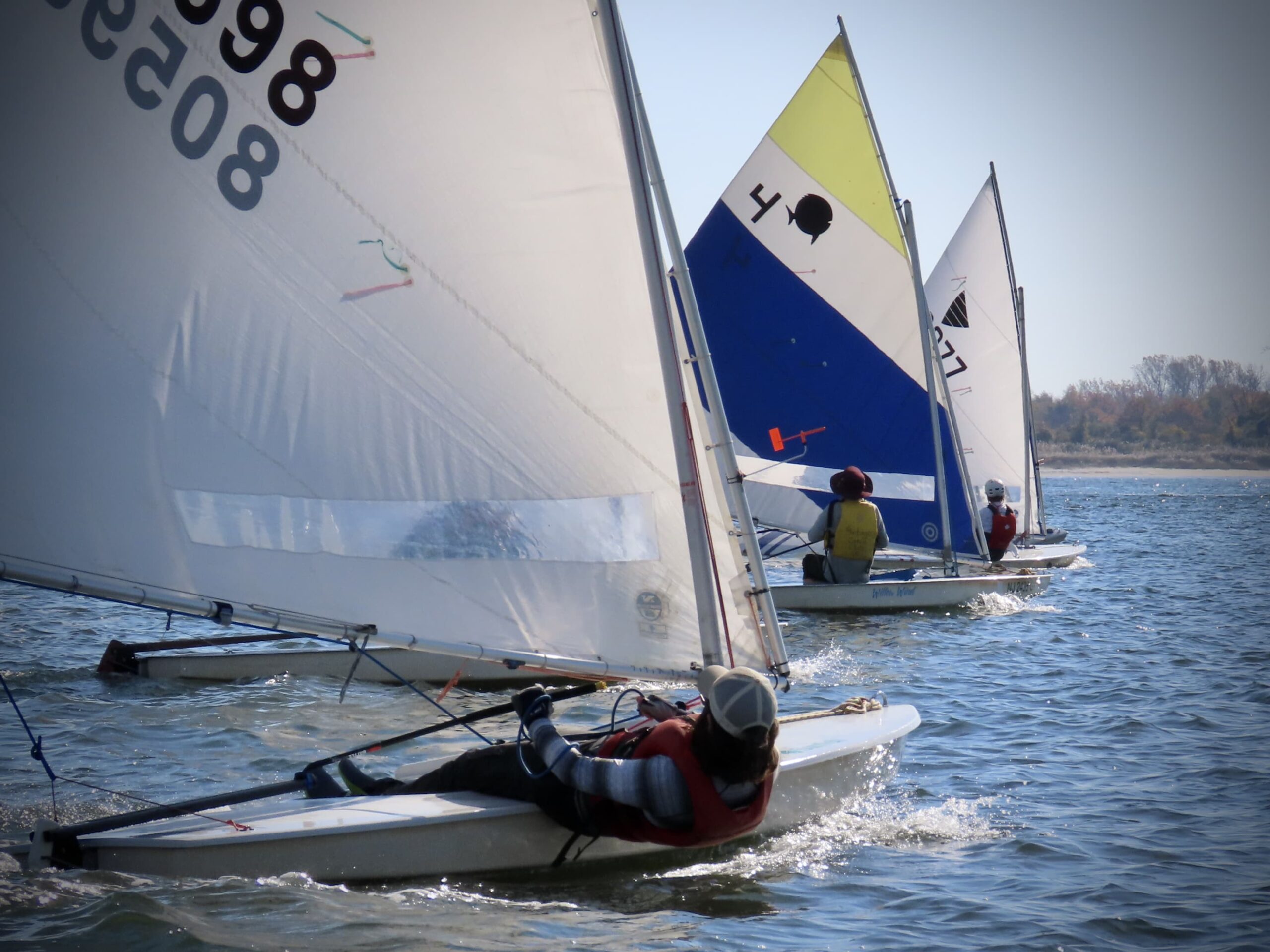
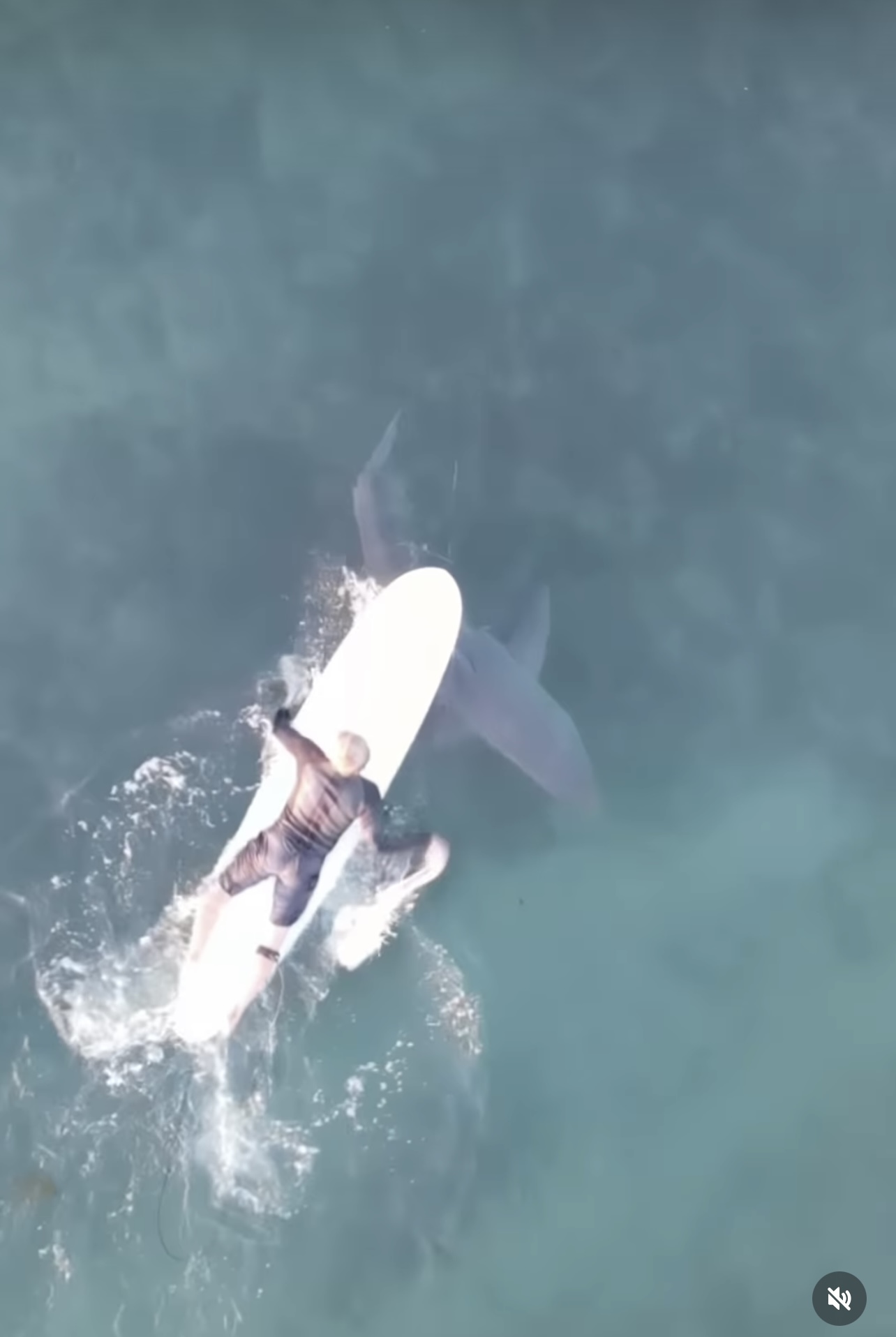
In that pic: practice makes perfect! Post-course practice sail, Start Sailing (ASA 101/102), October ‘24. They’re out under my supervision; I’m in our Carolina skiff chillaxin and coaching. Both boats have radios. They did their 3-day course and I’ve now cut the proverbial cord. Rockaway Inlet, with wide-open Raritan Bay in the background and Breezy Point out of sight to the left, which is the only thing separating them from the Atlantic. And whales.
For the past few years, we’ve posted what I call a “skeleton” schedule in the fall for the upcoming season. This means a basic assortment of schedules without cramming too much in. We flesh it out as the season approaches, and then progresses, based mostly on demand and instructor availability. Anything we’re contemplating last-minute is strictly based on forecasts and any gut intuition on how the weather will play out. So, even if we have an instructor available to set up a custom schedule at the last minute, if the weather looks like a losing proposition, we hold off.
Weather & whether… that’s always the question. And, that’s why we structure our scheduling with some gaps to deal with the occasional makegood required when we lose too much time to weather. Everyone’s different, but a certain minimum number of days and hours works well across the board. Most schools schedule only 2 days for learn to sail courses, and have 4 students in the boat. That’s never going to work. Most students in those programs are NOT ready to skipper the boat – they’ve only gotten a solid introduction to the sport. They almost always need more time.
Our learn to sail course, Start Sailing, is typically 3 full days with each day spent mostly sailing. There’s very little shoreside theory – just enough to explain how the sailing skills we’re about to practice work. So, day one has a session of about 45’ to an hour. Day 2? Less. Day 3? Usually none! Each day typically has two breaks: lunch, and a mid-sail break in the afternoon for extra stopping practice at the mooring and also for bathrooms and a mental time out. Sometimes there’s a third break, most often on days with all sailing and zero theory.
“I don’t have your brains if I have your bladders.”
– wise clinician at a snowboard instructor clinic years ago when asking if candidates (including this author) were good, needed a break, etc, to entice anyone to speak up and ask for one.
A few times each season, we have some variations on that 3-day theme:
2-day accelerated schedule for people with significant prior experience. This can be a refresher, or to earn the new ASA 102. It’s also good for people who did a 2-day program at other schools and have suffered ever since.
A weeknights schedule at the height of daylight savings. This is 4, sometimes 5, shorter sessions starting in the mid to late afternoon (as early as all students can arrive, but never later than 5pm).
We have some 2-day options scheduled already for 2025. The weeknights schedules are only added based on demand. You can ask us about that now, or in the spring. We can create one now, with the caveat being weather: you’d need to have flexibility to reschedule one or more sessions last minute based on that weather.
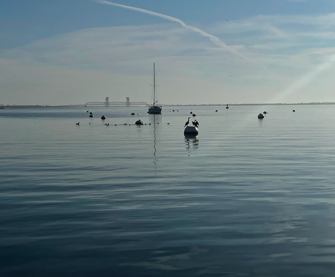
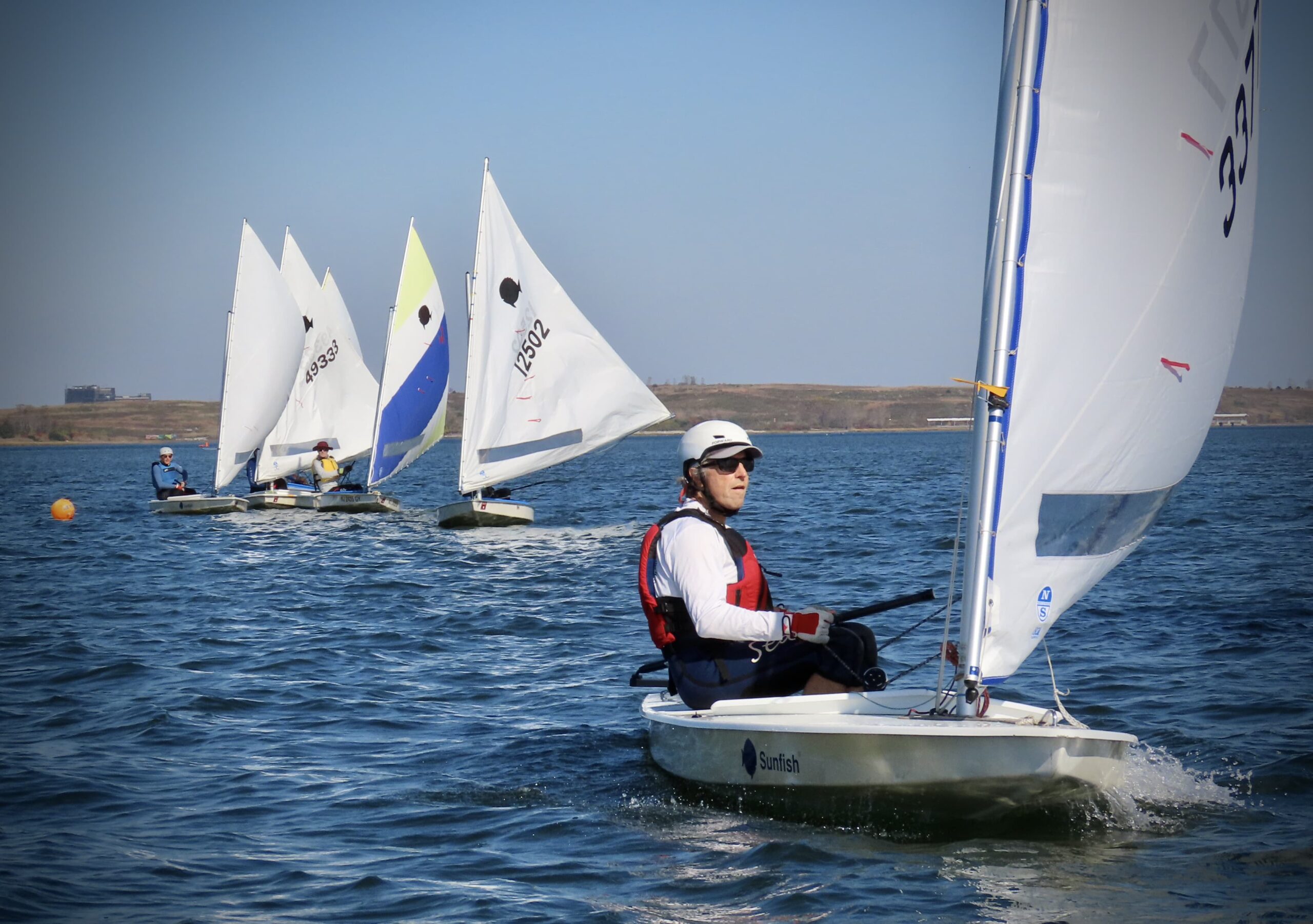
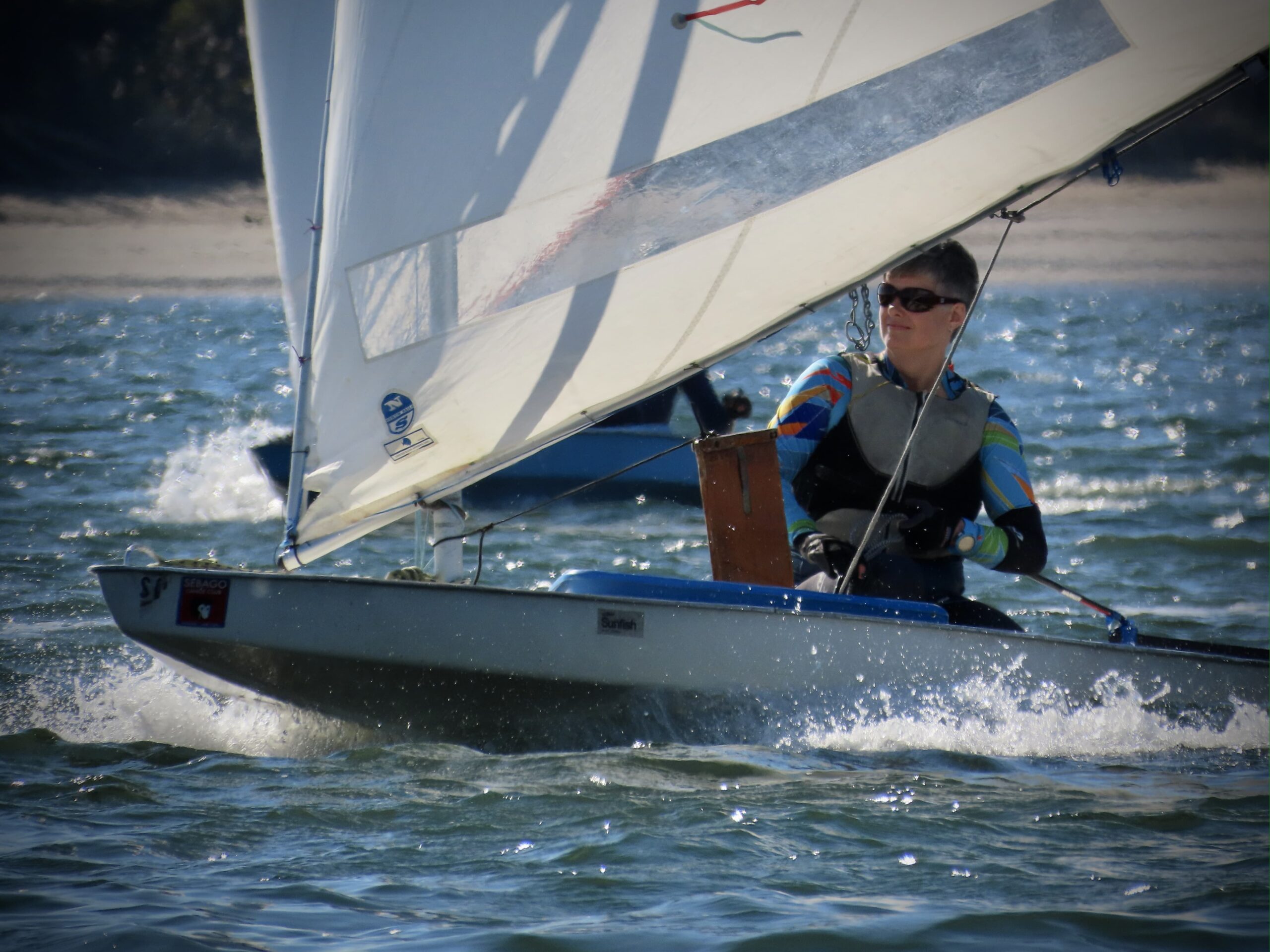
In that pic: The Dead Sea? No. It’s an unusually calm afternoon on nearby Jamaica Bay. Every area, even if generally windy, has some calmer sessions. See the dark band in the background, just below the island? That’s wind. We were racing Sunfish dinghies from Sebago Canoe Club and the wind went from shifty but do-able to light and variable. Isis is sprawled out conserving energy until the Race Committee decides what’s up. Me? I left. Figured I’d had a fun day with 4 races so far including one bullet and one near miss (1st and 2nd place) and it was a long sail back. Late October, 2024.
Also, we assign only three students to each boat, unless it’s a private group of four signing up together (and they’re told that the gen-pop maximum is 3 for perspective). With 3, everyone progresses quicker. With groups of 4, we sometimes need to add an additional half day or so to round things out.
If you can’t plan this early, don’t fret. We do add additional schedules as the season progresses. Also, while there’s an advantage in starting early because you have more season to sail after learning, some of the best sailing is in the middle to late summer. That’s because of the “sea-breeze” phenomenon. What’s that?
It’s when coastal areas get wind from the ocean in the afternoon. Details vary from place to place, and patterns have changed over many decades, but it’s like this…
Every day, as the sun gets higher, it heats up land masses more and more. Eventually, the land’s ability to absorb more radiation maxes out, and the heat rises as the sun keeps beating down on the land. When the hot air rises, something must take its place. Cooler air, which tends to drop instead of rise, comes in from the ocean.
It happens very suddenly and quickly; in a few minutes, one can see the dark band of wind on the water moving from the direction of the ocean toward your boat. It’s not like a line squall and thunderstorm – not THAT abrupt. But, it does roll in quickly. And, it’s often strong: upper teens to low 20-knot range is common. Fun! Cool breeze on a hot day – what’s not to love? Wind is good for sailing. The opposite? Not so much.
While a solid sea breeze can be a little much for some beginners, it’s predictable and stable. Once it kicks in, it’s fairly steady in strength and direction. That makes it easy to adjust to it. Big breeze? Small sails. If we were using a full mainsail before the sea breeze arrived, we usually “reef” it at that point. Reefing is making a sail temporarily smaller so it doesn’t lever the boat over, or heel it, too much. Some heeling is good. We deal with the heel by using smaller sails.
In that pic: dealing with the heeling. Small jib up front; reefed mainsail partially visible (the baggy part in the upper left corner). Sitting on the high side; getting a little spray. Breezy Point visible in the background. Boat is heading east in Rockaway Inlet, just outside of Sheepshead Bay. October 2024; private course for a couple from City Island (where we used to have the school).
Anyway, as well as supplying some flavor of what learning to sail can be like, this was to illustrate that we don’t have summer doldrums where we sail. Unlike the “Dead Sea” as sailors from our new are like to call Long Island Sound, we have wind most of the time down in Sheepshead Bay and surrounding areas. We’re directly across Rockaway Inlet from Breezy Point, which we see from the windows of our host facility, Miramar Yacht Club. It’s called Breezy Point for a reason. (It’s also called The Irish Riviera, but that’s for a potential future Rant…)
The net-net: book a schedule now if you can. You can always change it with some advance notice (4 weeks; sometimes less or even last minute if there’s demand for your original schedule). And, regardless of when you wind up learning with us, if weather gets in the way, we don’t just say “oh, well” like most other schools and certify you without you deserving it. We have you come back another time.
Here’s a link to our schedule/buy page to look at and, if you like pull the trigger on booking for spring or summer of ‘25…
Learning how to sail a boat usually winds down in summer, but fall is the best kept secret. This fall is surprisingly mild. Let’s get out!
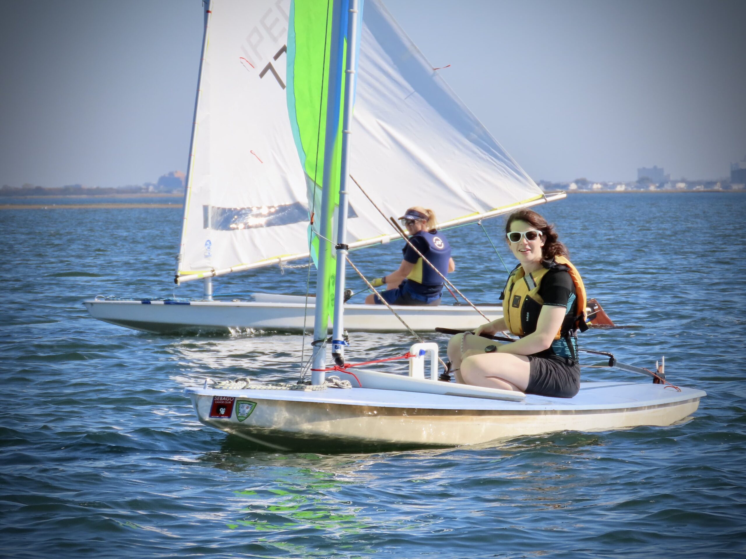
In that pic: two recent graduates of our Start Sailing course (ASA 101, Basic Keelboat) enjoying near bare-arm barometer in the fall. October 2024.
So, what were those conundrums? The summer itself. It saw relatively light winds with a few key exceptions. We did get the afternoon sea breezes, but they were less frequent and not as strong. (Strong is a very relative, subjective thing. One sailor’s boredom is another’s Victory at Sea.) It was a good weather season; nothing spectacularly good or bad. It was very productive in general with a few early/mid summer glitches (excessive winds).
While our regular schedule posted for the 2024 season shows nothing left, we’re not done. We always hold some time in reserve for makegoods and practice sails. We have enough time – and good weather – to do some private lessons on top of that. Those can be for individuals or small groups.
Complete beginners who want to get a flavor of sailing before it’s all over can come on out. Already a sailor, but rusty, or have some goal in mind to get over the line with? Even better.
The 10-day forecast as of this writing sees some seasonally reasonable overnight lows (meaning a bit chilly). But, the daytime highs are unseasonably mild. While I’m excited for the upcoming snow sports season (Wolf Creek is open in CO already for earlybirds), I’ll take this pleasant fall sailing while we can get it. Who knows… I might even race in the Sebago Fall Series on a Sunfish. Time to dust off my wet suit…
In that pic: yours truly (Director & Dockmaster, Steve Card) leading the fleet in a Sunfish regatta. I’ve got the sporty blue/yellow sail, which turned out to be a ‘practice’ sail versus a racing cut. It was good enough to keep me in front of the fleet in that race, and have competitive speed throughout the day. Sebago Fall Series, October 2023.
Learn to sail, ASA 101 + 102, began on March 16 and 17, the earliest we started teaching people how to sail a boat.
We didn’t plan it that way. Hard to plan at all with early-season weather. But, sailing happened this past weekend. We got a solid full day on Saturday, and half a day of sailing on Sunday before the light winds turned very quickly (as predicted) into Victory at Sea conditions, as we say. Students got a taste of strong, fast gusts and learned that while it can be stressful when learning, the boat didn’t care and the instructor had a few whoo-HOO moments!
Why then didn’t we plan it? The early shoulder season is tempting, but way too unpredictable and volatile. My father’s school always started in April. It was ‘spicy’ sometimes. When I started my own school decades later, I began courses in mid April. It worked… until it didn’t. Too many weather delays.
So, I switched it around. We would start with advanced courses in April, and learn to sail in early May. The first season I tried, it, we lost the first scheduled weekend of Bareboat Cruising to a storm. It was forecast to blow stink and chuck buckets on the first day, and simply be way to windy the second. I headed up to Vermont on Thursday night and was snowboarding a foot of powder the next morning at Killington instead. The predicted conditions down in the Sound prevailed. No one sailed.
IN THAT PIC: happy camper, as they all seem to be. Day One of the first course of the season.
The next season, we scheduled more conservatively. Nothing in April. Learn-to-sail began in early May. For Memorial Day Weekend, weather isn’t always perfect but it’s traditionally reliable for classes. So, we scheduled three of them: two boats of students for 101 / learn-to-sail, and one for Bareboat Cruising (3rd level, 104, and don’t get me started on that math but you may do so yourself in this Blog Rant).
How did that work out? The first two days were unsailable due to a nasty nor’easter, something we’d never experienced that late in the spring. We got one day in out of three. That set off complications with rescheduling, as the rest of the late spring/early summer was pretty shitty as well. Welcome to climate change!
So it goes…
Kurt Vonnegut
So, what made me think it was even a remotely good idea to start classes in MARCH!?
We’ve occasionally done a private lesson, usually for a group of 2 or 3 students coming together, in the ‘pre-season.’ It’s always a case by case, last-minute thing. In this case, we’d had a mild winter in the northeast. Nothing had changed. One couple, plus several different individuals, were interested in starting in March/April for various reasons. The couple is going on a private Virgin Islands (BVI) trip with us in late April, and another man needed to knock out his 101 if he were to join a relative doing a 103 course in May in another region.
Everyone understood there were no promises about when we’d complete the course if we started – only that we would complete it. Everyone was free last weekend. The weather looked reasonable, if not great, for beginning. All three had some exposure to sailing, and one was quite experienced and mostly bringing his wife up to speed with him so they could do 103 together with us in BVI.
And so, a schedule was born.
IN THAT PIC: Ensign sloops lined up waiting to splash at Miramar Yacht Club, our host facility. This is the boat we teach 101 & 102 on.
Both days were beautiful with partially cloudy skies and plenty of sun. It was cool out, getting chilly on Saturday afternoon, but that was due to a summer phenomenon: the afternoon sea breeze! Sunday was almost too light to sail at first, but by the time we got sorted and on the boat, it was enough to sail and practice meaningfully. As it was forecast to intensify rapidly at some point, we kept an eye on the updates and stayed close as it got closer to ‘oh, no!’ time. That happened when we were already just about in, and only had to negotiate a few moored boats en route to our own mooring.
They got to experience some strong, wicked-fast gusts that they would have had no business being out in without an instructor (and without the first day’s training). They had both, so they got to try it out. I had to sail the boat onto the mooring, but they got to fool around with steering and sail trim before that.
Two days with good sailing in March, even though one was only half, was a great start. Next weekend is out due to another nor’easter! Who knows what the following will bring, but there’s the first half of April and the weekdays in between it all to finish up. And then it’s off to the races. Or cruises. But the foundation will have been laid.
IN THAT PIC: copy-camper from same day (and family).
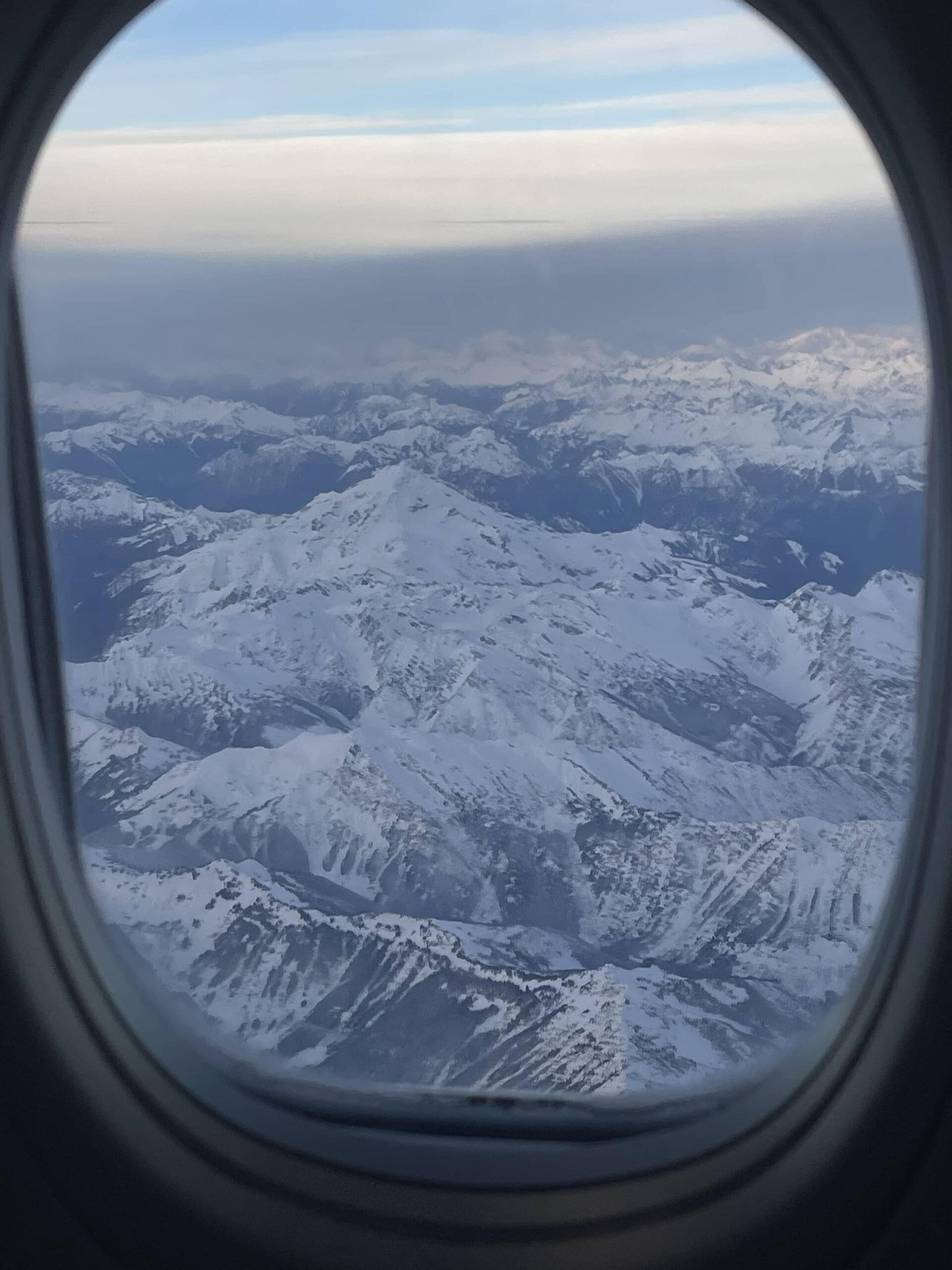
Not on a boat – by plane to ride a snowboard. But storm chasing to ski/ride is more like planning a boat delivery than it isn’t, so once you learn how to sail a yacht, you can apply this to delivering one!
IN THAT PIC: sneak preview of what’s to come. Aboard a very late Alaska Air flight almost at Seattle. Cascades? Olympics? Dunno.
Mid-January: I’m frustrated and feeling like I’m losing out on the winter. I haven’t hit a storm yet. I’ve missed many; couldn’t leave early enough for the annual Thanksgiving pilgrimage to Vermont, so missed that one. Couldn’t stay later than Sunday, so missed the next. And so on, and so on. One conflict after another and I had missed many shots both locally and out west. Got some days in but in average conditions at best including crowds.
What’s the hurry/rush? Well, snowboarding in powder is my favorite activity. (Yes; even more than sailing, and I LOVE sailing.) I started relatively late in life, so the novelty hasn’t worn off. Plus, as I advance in confidence and skill, and learn how to explore more areas and when, I get more rewards.
So, what do I mean by “storm chase” exactly? I mean that I don’t pre-plan snowboard trips in advance. I keep an eye on trends in different regions, and keep checking long and mid range forecasts. When those consistently call for a lot of snow in an area, I pay very careful attention to the trends when less than a week out. If, a few days before the storm, it still looks good, I see if the travel and lodging logistics would work. If everything alines last minute, I go!
IN THAT PIC: sneak preview of what’s to come – hopefully: upwards of 55″ over two days and nights! Could be too much if they can’t open due to road closures or avalanche mitigation. This is on the Open Snow app: free trial, then $30/year or so and worth way more. If you like powder riding/skiing, look up Luke Stone on Instagram and follow. Storm chaser extraordinaire!
Boat delivery: similar. What’s the weather window for the journey? What’s the expected amount of time? What is the margin of error and likelihood of running into overtime? What are the consequences? What does getting to the boat, and home from it, look like? How is that affected by weather as predicted and as it might change? These are many of the variables that factor into why I stopped doing any deliveries, whether on my own or helping other captains, awhile ago. (For deliveries, the boat itself is often the issue.) Last time I broke from that policy I was, of course, reminded why I had put it into place in the first place, but that’s another story.
This storm chase: the Cascade Mountains in Washington.
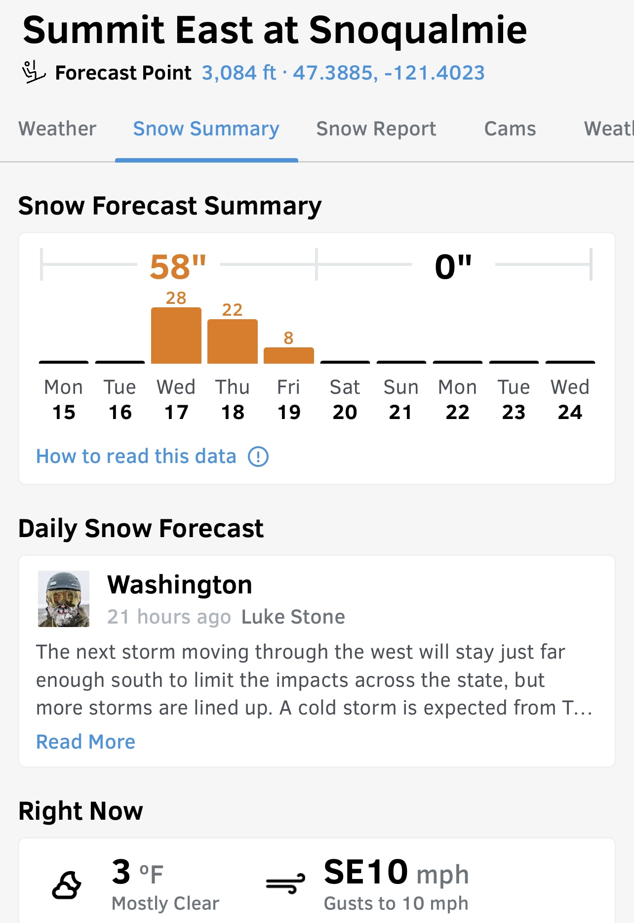
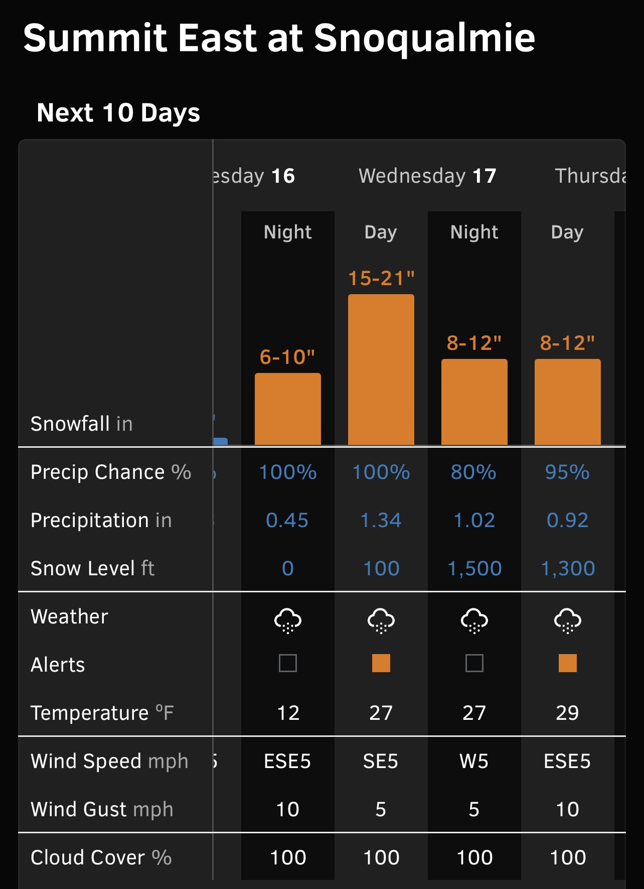
Target mountain/resort: The Summit at Snoqualmie + Alpental
Time of storm: Tuesday night through Thursday night (non-stop snow)
Intensity: 50-55 inches total, with most of it the first night into the next day
Airport: SeaTac
Ground transfer: rental vehicle
Lodging: The Summit Inn, across the street from part of the mountain resort
Access to mountain if roads unpassable: walk across the road!
Access to food if roads unpassable: downstairs, next door, across road
Weather windows to arrive before storm and depart after: Green light Go
IN THAT PIC: forecast broken down more specifically, and very helpfully, on Open Snow.
And so, I booked. Lodging was expensive for what it was, but almost couldn’t beat the convenience – especially as there was a restaurant on site that served breakfast through dinner. The resort itself has no lodging, so no ski in/ski out. But I could drive anywhere from a few hundred yards to a few miles to the different bases, and I could walk to one with my snowboard. I did all of these.
I knew that it was critical to get to the hotel before the winter storm got underway. I got down to the wire on that score. The morning of my departure saw a few inches of snow in the City, so I left earlier for the airport and upgraded my Carmel ride from minivan to full-blown SUV. That paid off. But then…
Airport: we left almost on time… only to stop for de-icing. That took awhile, and then they announced they had to go back for more fuel. (?) We’d also have to de-ice all over again. Don’t remember if we got that far along, but no one could forget that they deplaned us and delayed departure for another 3.5 hours. Some happy crap about timing-out and needing to change out some flight crew. Of course, they were supposedly flying in from somewhere else so I took that with a grain of salt.
That was strike two. One more time strike and I would have to bail out. Consequence? Costs of one night’s lodging, plus round trip taxis to JFK (over $100 each way). Not cheap. Plus, the sleep and time lost. It was supposed to be a 7am departure and was now going to be 1pm. If they delayed again, I was going to let them know to take my Sportube off the plane and I’d take it home. (Sportubes are two-part cases for ski and snowboard gear and they’re the best thing I’ve seen on the carousels so far.)
But, they boarded on time and left the gate on time. Yes, they de-iced again despite the snow having turned to rain a long time ago. But, better safe than the other thing. And, with no more hitches, we were off.
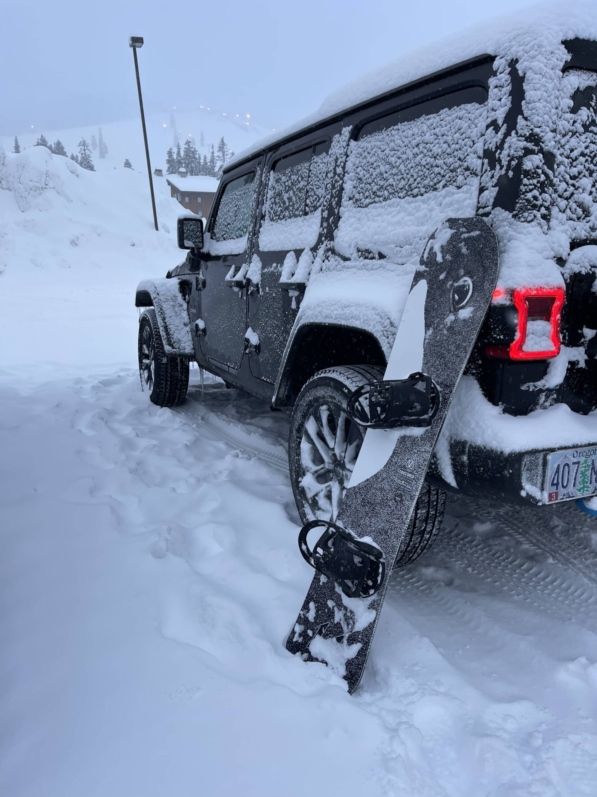
IN THAT PIC: two rides… my Jeep for the short week and my Lib Tech Orca snowboard. Toward the top of the pic you can see a string of pale lights: this is on the hill. Snoqualmie has night skiing at several of its locations and claims to have the most in the United States.
This put me at SeaTac in the late afternoon, dealing with rush hour for rental cars and driving. But, I still had enough reserve time to get to the mountain before the winter storm was supposed to start. Despite super gusty winds on the Snoqualmie Pass, and light precip, I was able to safely drive the second half of that ground leg. I’d made the wise decision to forego a proper stocking up on fridge supplies while still in Seattle and settle for some quick bare basics and takeout dinner. (I almost just drove to the lodging, but called to verify I was en route and to ask how late dinner was offered. Restaurant was closed! Gear-shift…)
The airport arrival, shuttle to car rental, and actual driving out of Seattle went quicker and better than anticipated. Sorting out the vehicle was slower but fine. I needed winter tires, all-wheel drive, or preferably both or, again, I wasn’t going. I got the all-wheel drive in the form of Jeep Wrangler Sahara.
That vehicle steered squirrely, but braked very well. It also drove well on snow, and there was a LOT of it up there. The roads were snow covered before the storm and it just got deeper and messier over that night and the next day. In fact, and as anticipated, I-90 closed in both directions once the storm got intense enough. That mean no one was going nowhere far, no time soon. That suited me: semi-private snowboarding at the mountains – if they were open!
Same risk – if they didn’t get enough of the work force to the hill, some or none of it would be up and running. I got lucky: everything opened basically on schedule with small delays with only Alpental not open on day one.
IN THAT PIC: How much snow was there? This much and counting. While it didn’t dump 50+ inches, there was already plenty and it snowed nonstop for 2 days and nights at varying intensities before becoming inconsistent.
What was I hoping to do? Surf powder! And, I got the goods. I didn’t get 50-55″ by any means, but got enough: between 15 and 20 over the 3 full days I had to ride, on top of other high quality recent fresh I’d missed. It stacked up in places to be over 2 feet deep. For the 3 days, I rarely hit ice or hard pack. I almost always had soft to deep snow under my board.
The Summit at Snoqualmie is a mostly locals resort. People day trip or do several days from Seattle and other areas in striking distance. All the locals I met at the bar or on the lift spoke to me about Crystal Mountain, Mount Baker and Steven’s Pass. They all said I had to do those. But, there they were at Snoqualmie with me!
IN THAT PIC: first chair ride up: watching others come down. This guy doing a little cliff drop was with buddies out of the frame (still grab from a clip). Summit Central, kicking things off on the first day.
The first one to discuss this with me was the second person who…
I met on the way to, or once at, a ski resort I’d storm chased, and:
Rode a fish-themed board;
Was Asian;
Wanted to buddy up for tree riding!
Enter Dzon, a Seattle guy doing a half-day at Alpental on Thursday. He rode a Burton Barracuda, which I recognized in the lift line as I’d owned one briefly in the past. We got to talking, and next thing I know, he’s showing me around the best routes and stashes in the best order based on when they’d get tracked out. We exchanged numbers for future storm chasing endeavors after doing half a dozen runs over the course of the morning and early pm.
(Last winter, I’d met Jack on the ski bus from Salt Lake City en route to Brighton + Solitude. That was my first dedicated storm chase. Jack and I had coinkydinkily lodged at the same motel in SLC and were planning on hitting some combo of Brighton, Solitude and Snowbird over the next few days. Jack was riding a Rossignol Sushi. I never had one, but my first board was a Rossi Taipan with skulls, flowers, anchors, steering wheels, and a foundering tall ship with a large sea serpent breaking through the hull. Most complicated graphics ever. Turn the board at different angles, and the color changes as well as the graphics. Wicked. Jack and I will eventually hit SLC again at the same time as we keep in touch.)
The Summit at Snoqualmie has 4 different areas (some say 5). 3 / 4 are lined up and interconnected along State Route 906. One can usually ski back and forth amongst them rather than drive or take the resort shuttle. (The shuttle doesn’t run during the week, which was a potential logistical snag in my storm chase planning I hadn’t realized until after booking.) The 4th is a little further down the road and not connected.
IN THAT PIC: view from the back windows of Alpental’s lodge up the mountain behind the access road. A few colorful crests on the walls made for nice decor.
The areas are Summit East, Summit Central, Summit West, and Alpental. The first three are small hills that some would find too tiny for their taste. Alpental is larger, although not intrinsically large. Want stats? Ain’t got no stats. Didn’t really care. I knew the locations were large enough for me, and the main thing was timing good snow during the week. I don’t do weekends except in Vermont, and very carefully planned at that. Point is, they get snow at The Summit: somewhere in the neighborhood of 400″ of average annual. It dumps frequently. Sometimes the snow is wet and heavy. Sometimes, it’s light and dry. This time it started quite light (on top of a previous dump of light powder) and got a little heavier as the cycle did its thing.
So, how does one get around DURING the storm? Drive as little as possible, and only walk where it’s safe. Both were doable. On the first day, I wanted to hit Alpental, but it was closed either due to avalanche mitigation (yeah.) or lack of staff. So, I drove the short distance down the road to Summit Central. That was, of course, after dealing with the fact that my room’s fridge was more like a freezer and had frozen my milk for coffee and cereal solid. Slight delay getting to the hill; missed the initial queue so more tracks were made on the snow before my arrival.
IN THAT PIC: the little car that could… and the little mountain it got me to. One of them, anyway. Jeep Wrangler Sahara, a solid snow driver despite not having actual winter tires. Summit West in the background, the base/hill across the road from my lodging at The Summit Inn.
Small problem; large amounts of powder remaining. Did a few runs there and at the Silver Fir area (has its own lift and runs). Silver Fir is the “5th” hill at The Summit. Central had a little of everything terrain wise – just as advertised. I stuck to runs where there should have been the most powder and/or ability to just plow pow. Being alone I stayed out of the trees other than cutting between a few right at the edge of trails were I could be seen even if upside down in a tree well with only the bottom of my board visible.
wha?
Tree wells! Serious trouble in some areas out west, and the Pacific Northwest is infamous for them. A tree well is the ring around a tree’s trunk that appears to be filled with snow, but only very loosely as the surrounding branches are widest at the bottom and don’t let as much snow get in (while trapping what’s there against the wind removing it). If you wind up sliding or falling into one, you can sink way down. If head first, you can suffocate. It happens every year. Deep snow immersion is a thing, and riding through trees, especially in the backcountry, has elevated risk. Even for experts. Only way to eliminate the risk is to stay on groomed trails. But, one can mitigate the risk.
IN THAT PIC: lots of trees! And, lots of snow. Potentially dangerous combo. Ride or ski with care. If in doubt, stay on groomed/main trails. View if from the parking lot at The Summit Inn, next door to the Chevron station and convenience store, looking east-ish.
After some runs in each spot and an early lunch break at Silver Fir (great little lodge), I decided to take an extended break before hitting Summit West at 2pm when they opened for afternoon and night skiing. That paid off with 3rd chair and untracked pow on a gentle blue with enough pitch to straight line the shallow pow (didn’t get as much here, and they had groomed after the previous dump). But, didn’t touch bottom! After a few of those runs I explored the two black diamond areas off to the side, each of which had trees as well as pow. This was cheating; shouldn’t really be doing trees without a partner. But, others were going through at the same time and the distances between open areas was short. Too tempting.
Day two was when I kicked things off at Alpental and met Dzon. Alpental is small but otherwise the real deal. Most of if is single black diamond terrain, with equal-ish amounts of blues and double diamonds making up the rest. Might be a green or two at the base. There are very few lifts, like at Revelstoke, but a fraction of the terrain as well. The first lift is a high speed and the second, often on hold or closed due to the terrain, is a slow double. So, lines at the Edelweiss chair are usually long. Didn’t get to go up there this time so no doubles for me on this trip. Maybe next time; definitely sometime.
IN THAT PIC: looking up at Alpental, from… Alpental! On the slopes; maybe 2/3 of the way down in the single black diamond areas to skiers’ left off the first lift. I’d tried to traverse far over and get to a great tree stash but couldn’t hold my edge long enough on this run, so settled for what I could get into from where I was. Didn’t suck.
The main run down the middle is a tough blue that, when there’s enough powder, would be a blast. I stayed along the sides and in the trees as much as possible with Dzon, and chose my tree spots more carefully when he wasn’t there. I put up with tiring traverses to skiers’ left to get into the single blacks and trees in between. For a snowboarder, it’s much harder to hold a traverse on one edge with no poles. (Backcountry riders often carry poles, and borrowing poles from a guide on a heli trip got me out of a tough tree run that was more like x country than downhill, so it’s worth considering.)
For the afternoon, rinse and repeat: Summit West. Did the same runs; there was some extra powder on top but not as much as the day before and it was somewhat heavier. Couldn’t get to the far left (Wildside) as the chair was delayed and then the main one was acting up. I got cold and tired on a long haul up with more time stopped waiting than moving. Disappointing but it happens.
Day 3: more Alpental in the morning, but only a few runs. I was running out of steam. The long traverses were getting to me. (Must get in better shape for this.) They didn’t get a lot of extra snow overnight, but enough for a topping off. That helped.
PM: got over to the Wildside finally! And it was worth it. The whole of Summit West is small, and Wildside is just one side. But, it’s higher and steeper with some variety to the terrain. Locals had all said it’s good, and they were right. I found my jam right away by not coming straight down under the lift but instead circling around back, where I found good trees to the left with a steep drop but plenty of room, and a visible end to it. Looked too flat at the bottom to continue riding out to the main slope, so I bailed early and traversed across the wide open bowl (for lack of a better word). This has irregular, wind-blown snow that was minimally tracked, so it was fun to play around in it on the way back to the lift. The beginning of this area, as hit on the way down, allowed cutting back across to the base lodge seamlessly.
IN THAT PIC: part of my sort of secret stash, Wildside area, Summit West. This was my last afternoon. Screen grab from a video clip. Some pretty steep sections, but with fresh pow! Could surf the pow or do the moguls with sticks in them (trees). This is an interesting if small area, but it’s not too small to enjoy even if you like long lines.
I hung it up around 4:30 that afternoon despite night skiing being open until 9:30, conditions permitting.
Next logistic: getting home! All I had to do was leave early and hopefully not hit bad road conditions. When I planned this chase, I expected rain on Friday and possibly into my departure morning on Saturday. That would have been fine, but I didn’t even get that. The Interstate was open and unrestricted. Small patches of compacted snow/ice here and there but the few vehicles traveling westbound were flying. Not so much heading east from Seattle: Seattle was on its way to The Summit! It was very obvious. I was going the right way at the right time.
IN THAT PIC: right way, right time – for me, not everyone on the left racing from Seattle to The Summit at Snoqualmie. Think: the race to get the last moorings in a crowded anchorage where actual anchoring is not allowed. Must get there early and claim your spot. Timing for deliveries (and cruises) is like land logistics for storm chasing.
Dropping off the rental and airport logistics were a breeze. I enjoyed a solid if not spectacular fish and chips plus salad at 10:30 leisurely with a view out of the Olympic Mountains. Killed some time with a coffee and flew home. Only snag thereafter was waiting almost 1.5 hours for my snowboard case. I’ve had to wait about an hour or longer three times now at JFK. Will make the complaints, fight or not over the meager comp offer if any, and seriously try to avoid JFK on the return flight. The issue is that I book last minute which hampers my options. Waiting another hour to 1.5 after a great trip is annoying but a small price to pay.
Would I do this particular chase again? Yes, as long as the coast is clear to get to Snoqualmie before the roads might close. I was considering the vbastly larger Crystal Mountain for this trip but it looked to be getting considerably less snow than Snoqualmie this time around. I didn’t check what they actually got. But, Crystal was close to 100% open recently when I checked, and with over 5,000 acres, there would be untracked pow all day for days if one hunted for it. Snoqualmie has closer to 2,000, but it does fight well above its weight class – especially with Alpental in the mix!
“Dining”
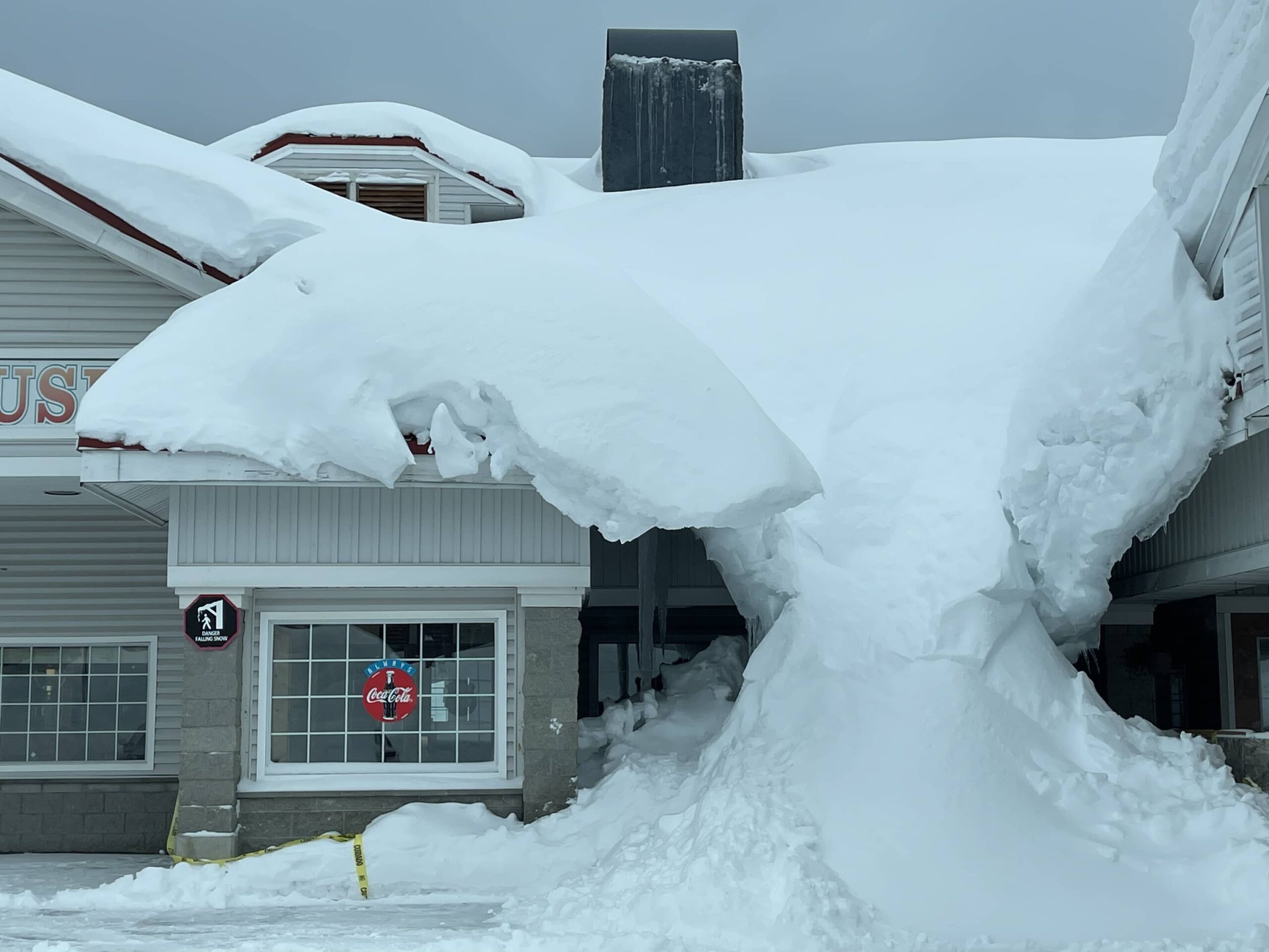
IN THAT PIC: The Summit Pancake House, ostensibly a different business but attached/walk through from hotel lobby and same people going back and forth. Open… inconsistently, and apparently, almost buried here. Almost had to try the pancakes through. Almost.
Never did eat at the restaurant on site: the Summit Pancake House. On the first morning, I was going to try the pancakes but bailed when they couldn’t tell me whether they had real maple syrup or just the ultra-processed shit. Not paying good money for crap. That soured me on trying them for dinner – if and when they were open for it. So, I ate my muesli that I’d packed and made my own pour-over coffee.
Lunch: on the hill day one at Silver Fir. They had nice looking lodge food, and their terriyaki chicken with broccoli was excellent. Day 2: ? I think I just tossed down some cereal. Can’t remember day 3.
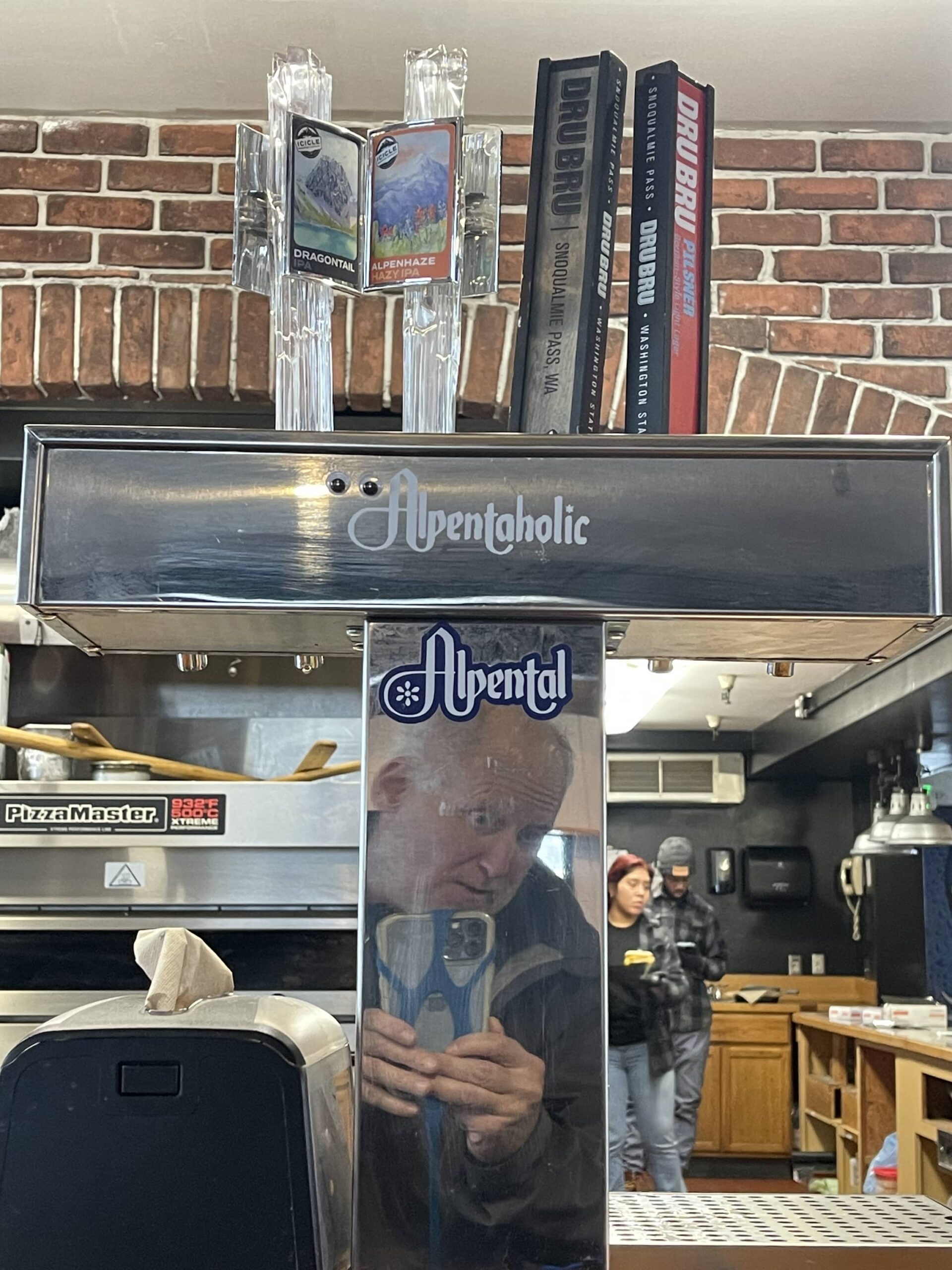
IN THAT PIC: dork with his phone leash capturing the Alpentaholic etching on the stainless. They sell Alpentolic stickers – not Alpentaholic. Would have bought the latter. Alpental base lodge during a coffee/breakie sandwich break between runs.
Dinner: 3x at Commonwealth across the street from the Summit Inn. Looked good, came recommended by locals, and it didn’t disappoint. Bar scene was nice and tables were mostly longish community seating with half of it high tops near the bar area. Food was solid; good beers. Didn’t dive deeper than that. On the first night they said they were indeed open before I strolled over, but added “as long as the power stays on.” So, I hustled out the door.
Back-up/emergency plan: Chevron station next door to the Summit Inn almost never closes, and has snack food plus some frozen pizza and burrito stuff. Something constituting hot food to tie one over. Next time, I’d shop better in Seattle on the way out as there’s a Town and Country (Basically a Whole Foods) that’s an easy, quick detour with mini-mall parking. This is where I did my quick stop completely by accident: once I heard the lodging’s restaurant was closed, I pulled over to find something and got lucky. Have to take the luck out of it next time.
Boat delivery, storm chase – more similar than not in the planning stages. I’d rather mess up the planning on a storm chase than on a delivery however. Being stuck at the lodge or the airport is safer than being caught in an actual storm on a boat.
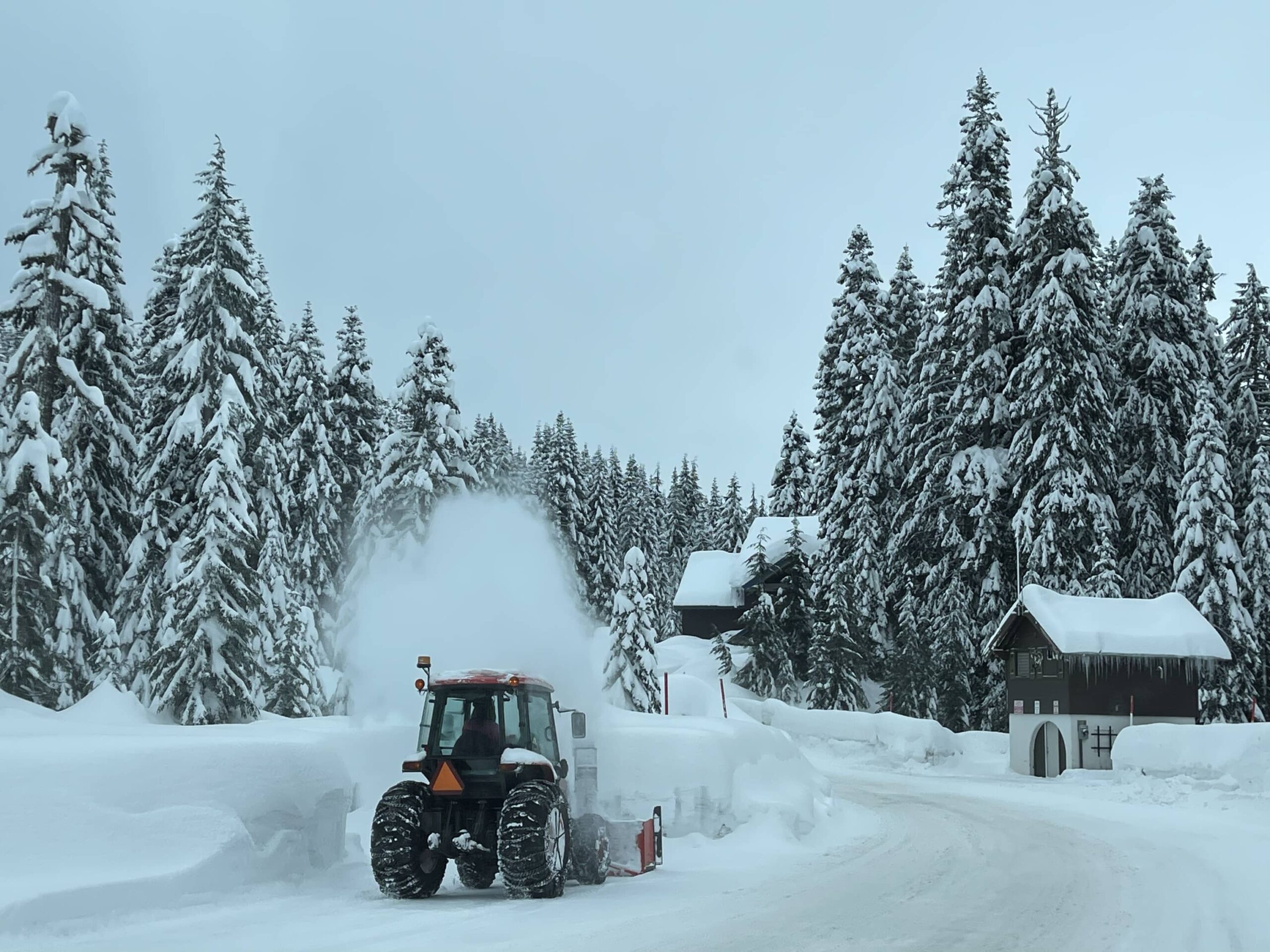
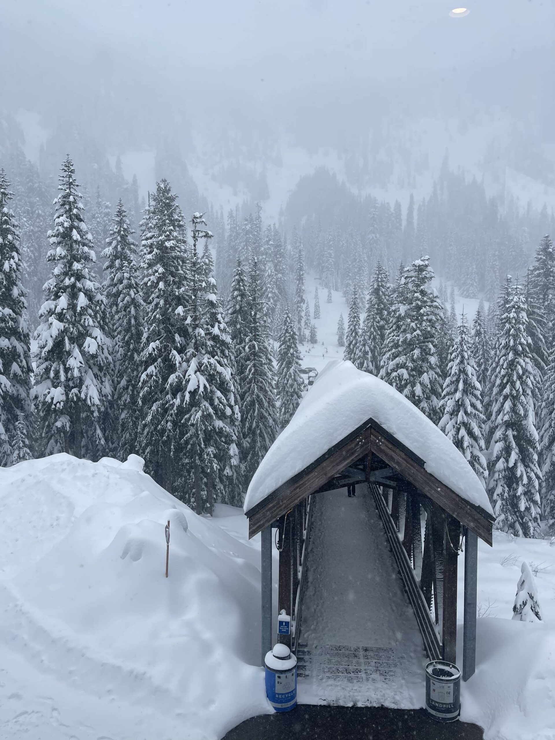
IN THAT PIC: looking out from Alpental lodge over the covered bridge to and from the main parking lot. It crosses a creek and it’s beautiful; the views in some spots through the trees are spectacular.
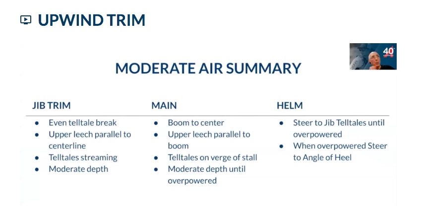
We’ve actually been doing the new 102 in our learn how to sail / ASA 101 for decades. Who knew? All of our past students; soon that might be you!
UPDATE to original posting: our Director, Captain Stephen Glenn Card, is now certified at 202, meaning he’s authorized to teach and certify students for 102, and one of the earliest instructors to earn that rating.
We’re setting up ASA 102 schedules now for March and April, before our full 3-day 101/102 courses begin. Prerequisite:ASA 101 or comparable experience and skills. Can also do this as private instruction. Contact us to discuss, or read on for more about 102.
I’ve lost more time than I care to calculate with an abacus or slide rule explaining what 102 was over the decades.
There IS no 102.
Me…
There is NOT one.
Myself…
ASA missed that one.
and I.
So, it was with a combination of surprise and relief that ASA recently announced they’d filled in the gap. What is it?
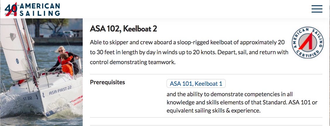
IN THAT PIC: Screen grab from ASA’s site showing what 102, Keelboat 2, is about.
It’s largely core, critical basic sailing skills that were never mandated in the 101 standards. It also has good content that, while not mission critical, is important enough that we’ve always included it in our 101. And, by always, I’m talking over 50 years of family therapy – er, experience – which began well before “101,” or even ASA, existed.
We sort of saw this coming. In 2020, I wrote a prescient post with this title: “‘102:’ When 101 Didn’t Add Up For You.” ( This rant was about how our course was complete, most others weren’t, and why we were planning to add a clinic to finish what other schools started.)
What’s in the new 102 that wasn’t already in 101? (Again, we’re talking ASA’s standards, not ours.) Major skills in 102:
heaving to (2 methods)
approaching moorings (2 methods)
getting out of irons
sailing backwards
steering with sails and weight
quick-stop MOB (as an addition to figure 8 already in 101)
reefing (barely discussed in the online 102 course; not on test)
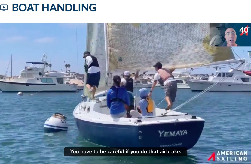
IN THAT PIC: Screen grab from the ASA 202 IQC online course (was live; available to instructor candidates to use for exam prep once registered for the exam). Here, the boat (a Harbor 20 if not mistaken) approaches a mooring on a reach. Note the circus clown/gymnast trying to push the boom out to stop the boat. Just don’t. Note also the mooring lines laid on top of the buoy; someone has to reach down and grab it by hand. Where’s the boat hook, Bob? Amateur hour IM(not so)HO. Either use a pick-up stick on the mooring line, or use a boat hook.
Most of the rest of the content is about sail shape, trim, lift and power, and weather helm.
Of all the things above, here’s what we don’t already cover:
sailing backwards (we discuss but don’t do as the technique is dangerous)
quick-stop MOB (as we disagree with it and think it’s dangerous)
That’s it! While 102 goes into more detail on sail shape than we do, we cover all the same stuff in our 101/Start Sailing course.
I think it’s a disservice to students and an insult to their intelligence to not start courses with sailing theory: how sails use wind to create power, and how that makes a boat go. Therefore, I’m a fan of keeping that in students’ minds and refining it. This is the “why” that governs all the “wha?” So, when ASA announced that sail shape was an integral part of 102, I was on board with that.
IN THAT PIC: Screen grab from the ASA 202 IQC online course. Here, the narrator summarizes sail trim sailing upwind in a moderate breeze. I screenshot that as they had some confusing inconsistencies in their explanations and advise, and I wanted to make sure I knew what they wanted to see on the exam.
What else is in 102? Some examples…
How to use a winch and winch handle safely (covered in 101 but I guess worth repeating)
Basic nomenclature (redundant).
How to tack and jibe properly in detail: timing, weight placement, who does what when, etc. (Good; refines the basics.)
Heading up and bearing off in more detail (also good, although it’s so simple 101 should have taken care of it)
Ducking when getting around a moored or anchored boat (excellent; we already teach duck or tack. For some reason, they never say tack. It’s often the better choice.)
And more!
I disagree somewhere between mildly and militantly with some of the curriculum and techniques; you saw that above with their mooring approach and using the main as an airbrake. Having said that, the idea is to give students more skills, more comprehension, and more ideas about their sailing future. We can work with this.
Another example:
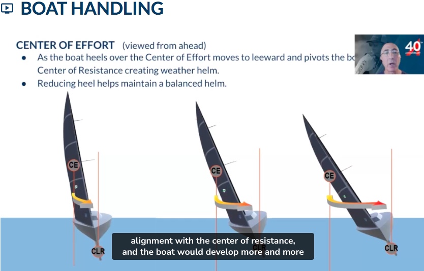
ASA says that heeling causes weather helm. Agree. (The wrong choice of sail plan can also do this.) But, why? They say it’s because the CE is out to leeward, or sideways, of the CLR. CE is Center of Effort (geometric middle of the combined sail plan in use). They say this causes rotation that turns the boat into the wind.
IN THAT PIC: Screen grab from the ASA 202 IQC online course. Here, the narrator compares boats with different angles of heel (sideways lean). He opines that when the sails get over to the side, their force rotates the boat around the keel in the water. Nah! IM(not so)HO.
We say: nah, bruh… It’s the heeling itself that causes the weather helm. Why?
Unlike the ones depicted above, real boats have real curves. Pushing a boat’s curved, buoyant surface down into the water on the leeward side makes the boat follow that curve. Surprisingly similar to pressing down on the edge of a ski or snowboard and “decambering” it (depending on type of shape of course), and locking into a carve. The plank follows the curve. Our students who ski or ride at intermediate or higher levels get the analogy. Those who don’t get the explanation without the analogy.
ASA’s idea that the sail forces (CE) have a rotational component misses how lift works: the net sum of the sail plan (CE) has a final, single velocity: direction and power/speed. The direction is diagonally sideways to the boat, but in a straight line. It tries to pull whatever it’s attached to IN THAT STRAIGHT DIRECTION. The shape of the boat plus the keel underwater resist getting pulled sideways, for various and interesting reasons we cover in day 1 of 101. (ASA’s 102 course explains how the keel develops lift to stop that; good. This belongs in 101!) In fact, when the boat heels, the force is no longer horizontal to the water’s surface. It’s slightly to moderately downward as well. That not only increases heeling, but decreases the net drive forward as the energy is wasted. Instead, it increases the rotation of the boat caused the boat’s curved shape itself!
ASA points out that when pushing the main and boom all the way out and forward to sail backwards, it tends to turn the boat the other way (rotation) and therefore one probably has to offset the rudder slightly. That’s a rotation I can get my head around. They wisely point out that the rudder should be held firmly with two hands, although they don’t illustrate “why” well enough. We cover that concept in our cruising courses as, with engines that are BBB rated (Balls Beyond Belief), the rudder will slam hard over as the pivot point is behind the rudder rather than the udder way around when goin fowad. It’s dangerous in both cases: tillers swinging hard over, and wheels spinning freely, can bust you up quick. Plus, the entire steering system can be damaged and disabled.
And, so, I “took the lesson” as my fencing coach in college would have said, and then took the test…
IN THAT PIC: Congrats – I passed! 94. Not as high as I’d like to have seen, but as 90 was the minimum for an instructor, I’m fine given how much I disagreed with plus how much was confusing. So, I get 202 added to the list of my certifications: 102 Instructor.
So… how are we going to handle this 102 stuff? That’s in the works now. Plan A is to simply offer the 102 with the 101 for new students. As it’s not a prerequisite for anything else, and therefore “elective,” they can choose to take the exam or not. Same education either way. If they choose to, they can pay the fee for the extra ASA textbook when it’s ready (not at the time of this writing) and do the exam.
We’d also offer it as a stand-alone clinic/course for our grads who are rusty, or for highly qualified graduates of other schools’ 101 courses. That’s the logistical bear to burden us. We’ll figure something out.
But, it’s nice to know that we’ve been doing this, more or less, all along… giving you more of what you go to sailing school for!SM
Fly down to the beach? Fly out to the Rockies? Drive up to them thar Catskills? Or, ponder how to sail on a milder day right here in Brooklyn? Plenty of choices.
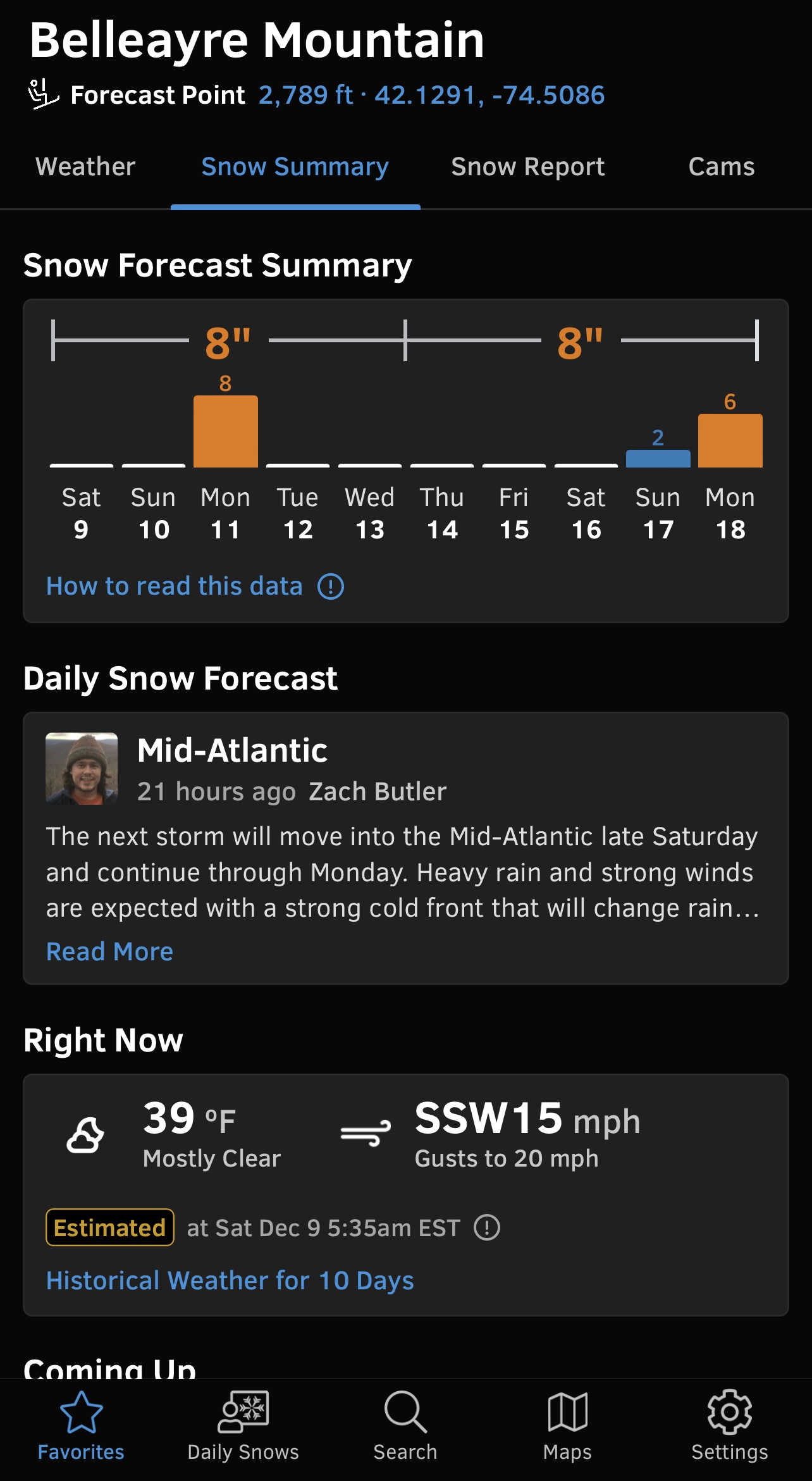
I wanted to drive up to Belleayre Mountain in the Catskills yesterday. They were forecast to get 4-6 inches of pow overnight with another few possible during the day. I even got the ticket on line and refilled my Ski3 card for direct-to-lift access. But, it wasn’t to be.
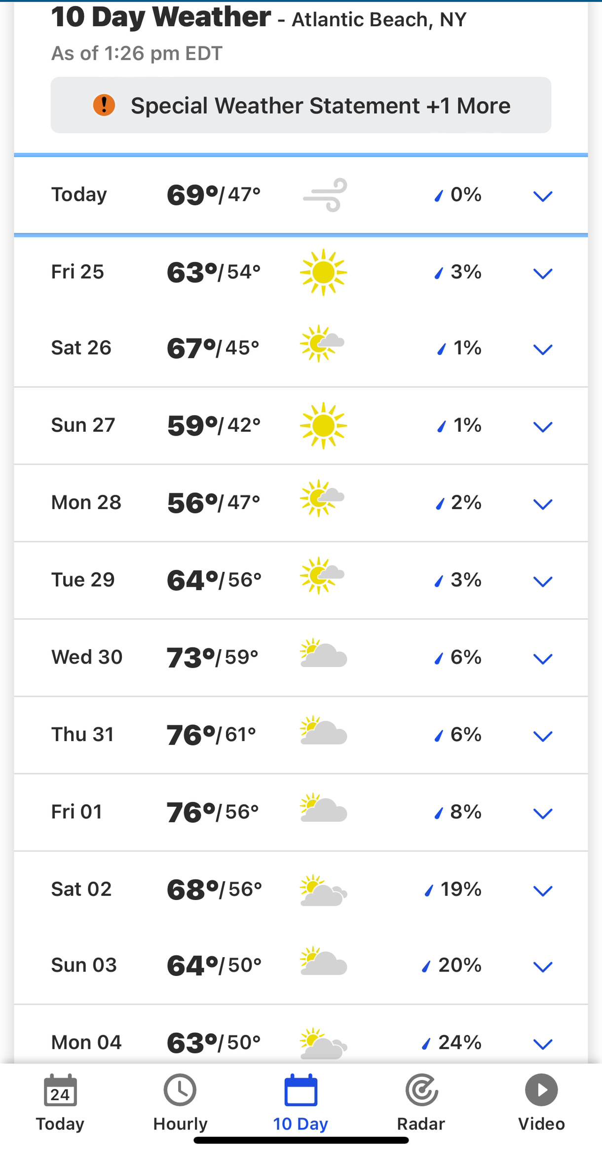
IN THAT PIC: screenshot of the summary forecast for Belleayre Mountain in my OpenSnow app, before expanding that below. OpenSnow is a top-tier app for mountain weather predictions. It’s gotten me some epic (Ikonic?) storm chases. Free trial; $30/year thereafter and worth soooo much more.
Yes, they got the goods: 7 inches as of the morning check! But, I didn’t sleep well enough and despite actually getting up at 5:15, went back to bed within 20′ and said F it. Maybe the next day. (Little to no fresh pow would be left, but packed powder all over and no stampede to get to it.)
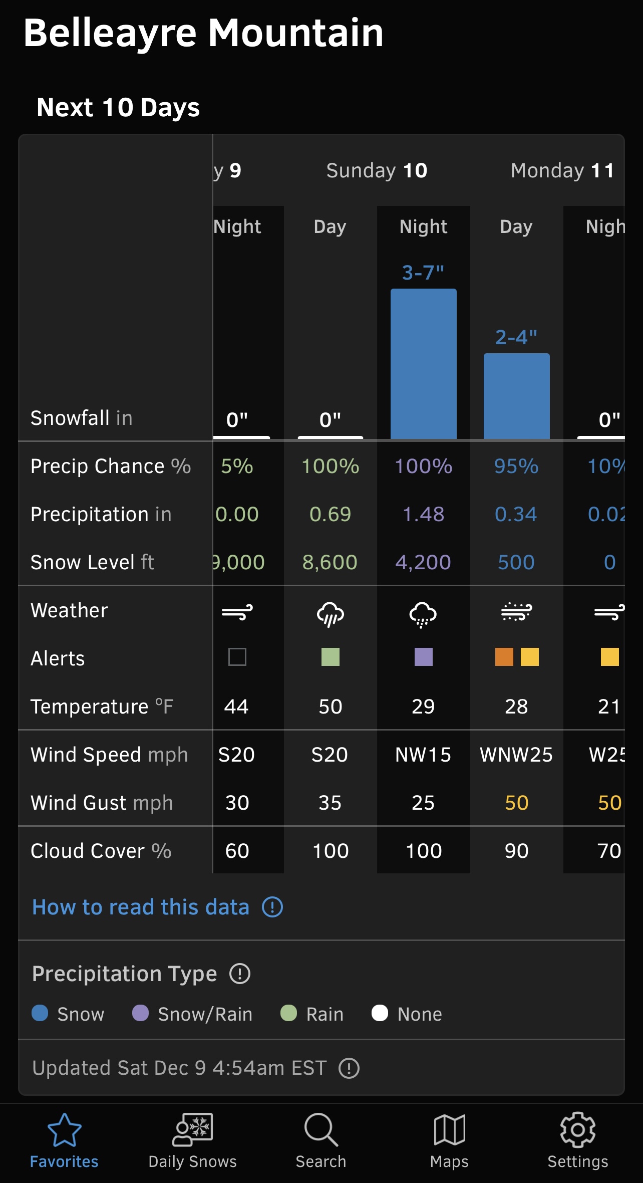
IN THAT PIC: forecast details expanding on the pic above. This makes it easy to see the timing of things, and the consistency and trend, which determine not just when, but IF you go. This was two days out. Final forecast was for 4-6 overnight and another 1-3 during the day. Actual snowfall as of early Monday morning when they first measured it? 7 inches.
Plus, I was stressed about getting ready to fly down to Florida to visit my partner’s family. Yes; looking forward to it, despite not being much of an FL fan. But, I’d play tennis to help get in shape for snowboarding, maybe cast my fly rod from the beach for practice and, you know… never know what’s right there within casting distance in salt water, where anything can swim anywhere it wants to.
I love the fam, so there’s that. And, I enjoy flying for some reason. But, I have to knock stuff out and get caught up before I go for 5 days and then wind up behind again. So, no. Didn’t take the whole day today to shred groomers.
Usually, when I fly down to the Virgin Islands (BVI) to run Sailing Center trips, it dumps up here upon my departure. Then, when I return, it NUKES and sometimes delays my flight getting back. I miss it and figure I’ve got it coming to me another time. This time around, I missed some storm chasing opportunities in a variety of places not because I’d left, but because I wouldn’t have enough time before my flight south. So it goes…
For this trip, it’s looking very quiet snow wise for the time I’m away plus some more for good measure. Maybe that means what comes later will be bigger and badder. But, if not, what about local sailing?
IN THAT PIC: all quiet on the inlet. View from Sheepshead Bay out into Rockaway Inlet, with the bridge separating that from Jamaica Bay in the background. Saturday morning, December 9. Those are cormorants or loons on top of the mooring ball.
It’s been relatively mild here in NYC. On Saturday, I was dressed in a fleece top and sun hat while doing crankcase and lower unit oil changes on our Carolina Skiff and checking the Tartan Ten on its mooring. By around 2pm, it was just about T-shirt weather for about an hour. Miramar YC was having a whiskey tasting, and allegedly also a pipe pairing. I had to pass as I was driving back to MannyHanny.
Saturday was a great temperature for sailing… but not really enough wind. Dead on the Hudson and NY Harbor; light down in Sheepshead Bay and Rockaway Inlet. There’s almost always more wind there, even when it’s light all around. Four to five more knots and I would have postponed some of the chores and dragged some people out for a sail. But, there will be other opportunities. Always are. (Want in on that? Hit us up to be e-blasted when we see a weather window!)
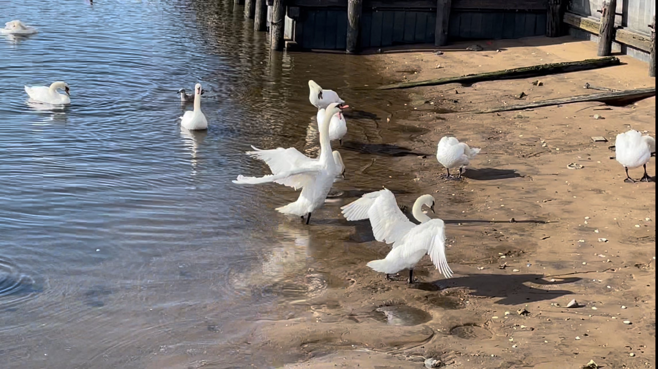
IN THAT PIC: Some of the swans at the beach that day. There are quite a few more outside the edges of the shot. Two of them were flapping away in tandem – synchronized swatting or something. Did you know they sail? They’ll travel downwind by flaring their wings to provide surface area. Feet steer.
I’m a life member at Hunter Mountain in the Catskills, which is the most well-known of them. My folks bought a house on the Mountain when I was wee. Either it came with life memberships, or there was a promotion so good my Dad was glad to buy for the whole family .Mom? I asked her later in life if shed’ ever tried skiing. “I did it once. That was enough.” Damn…
Dad was really into it, and I went to ski-school and stuff until they sold the house. Then, we maybe did one more trip in Vermont before they pulled the plug and that was it for snowsports for me and I wasn’t quite 10. It wasn’t until after I’d taken up snowboarding 14 years ago that I discovered there were other hills to ski/ride on in the Catskills. I heard of Windham first. A client from the school turned me onto Belleayre during the pandemic. He’d bought season passes for his family as a way to get out and do stuff in fresh air without being too crowded, and they were cheap. The mountain was almost empty and they had semi-private skiing. And, they liked the hill.
I’ve been there twice now; wanted to go more, but I rarely go to the Catskills now as it’s usually better for me to drive the extra 2 hours and be in Vermont. But, I prefer Belleayre to Hunter and Windham. Hunter, especially, has a lot of potential compared to Belleayre. It’s larger, has longer runs, has more tough terrain, and has its truly beginner and expert areas separated from the main mountain. Plus, they expanded the resort into a new area and added an extra high-speed chair in that area for some of the most efficient lap-making one could conceive of.
Yes, but…
Hunter isn’t being run the way it used to be. It’s been sold several times, and now everything kicks up to Vail Resorts. They seem to have bought it for market share in the Epic/Ikon struggle over the skiing Universe. They don’t run as many chairs as often, don’t make as much snow, and don’t open up the new North area or existing West areas to as much capacity as needed. Plus, their new glade in the North area seems to never be open – which it needed badly, as there were essentially none before this. They don’t seem to care.
Belleayre?
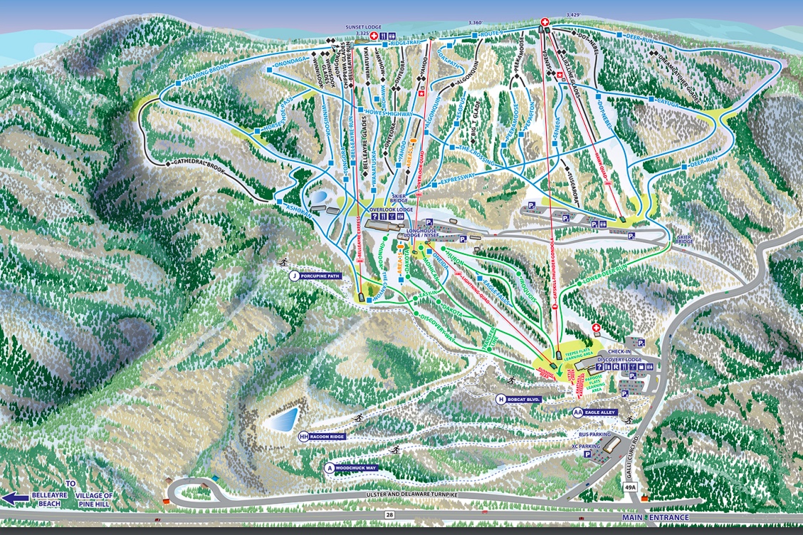
IN THAT PIC: the Belleayre trail map. It’s very left & right, like Brighton in Utah. That’s where the comparison begins and ends, but for a small northeast hill, it fights above its weight class with a nice balance of terrain and legit glades. Plus, they seem to put some effort into their terrain park.
It’s state owned/operated like Gore and Whiteface, and there’s some connectivity in pass and ticket sales, including the state’s Ski3 discount card. My take, in no particular order:
It’s cheaper. A full price walk-up-to-window ticket with no discounts is $104, and if you purchase as late as the evening before, it’s less. Buy a few days earlier, and it’s much less than that. Plus, they have a frequent skier discount card that’s worth considering if you’re not sure a season pas is worth it.
It’s run well! They have their act together and act like they care. (Same for Gore and Whiteface, in my opinion, after one visit to each on my two shots up north to get my COVID shots during the pandemic up in Plattsburgh.)
Belleayre seemed to get more trails open earlier than Hunter and Windham this season, and they blow a lot of snow. Plus, they get comparable real snow. (This time, they got significantly more.)
They have GLADES! Real ones. If you like trees, you’ll love Dreamcatcher and some others. I went up twice; neither time had there been a dump before I went. Both times, Dreamcatcher was open. And, it had good snow and some of it deep! (It’s one of their double diamonds and it’s the largest of their glades.)
Don’t like glades? No problem. They have plenty of groomers for all ability levels. If you’re a true expert, and especially if you’re an extreme terrain skier or rider, Belleayre might leave you feeling flat. But if you’re most things less than that, you should be able to enjoy Belleayre.
They have a nice mid-mountain lodge with a great bar and nice views from it. Doesn’t hurt that they have decent coffee.
They have a gondola! That means when it’s running, you can usually skip it to cut down on lift lines. Plus, they have one high-speed quad that runs in another area and lets you lap a large portion of the mountain quickly.
There’s less hill work on the local roads driving to and from the hill. That’s important in crappy weather.
Caveat: No lodging right on site, however, unlike Hunter and Windham – so, if you’re going to hit it during a real dump or just after, and you have to drive a ways, it might not be the call.
And, back to sailing! What if you want to just sail here in the winter?
Check out “frostbiting.” It’s short course racing in the winter, and there are a number of ways to play. Most of it’s on dinghies: they can flip over and you’re likely to get wet at some point even if you don’t flip. If you’re up for the challenge of dinghy sailing in the winter, game on. Dry-suit time. Unless, of course, you’re racing Dyer Dhows at Mamaroneck Frostbite, where it’s hard to get spray on you and also harder to flip over. But, if you do, you’re getting very wet. So, a dry suit isn’t a bad idea here either.
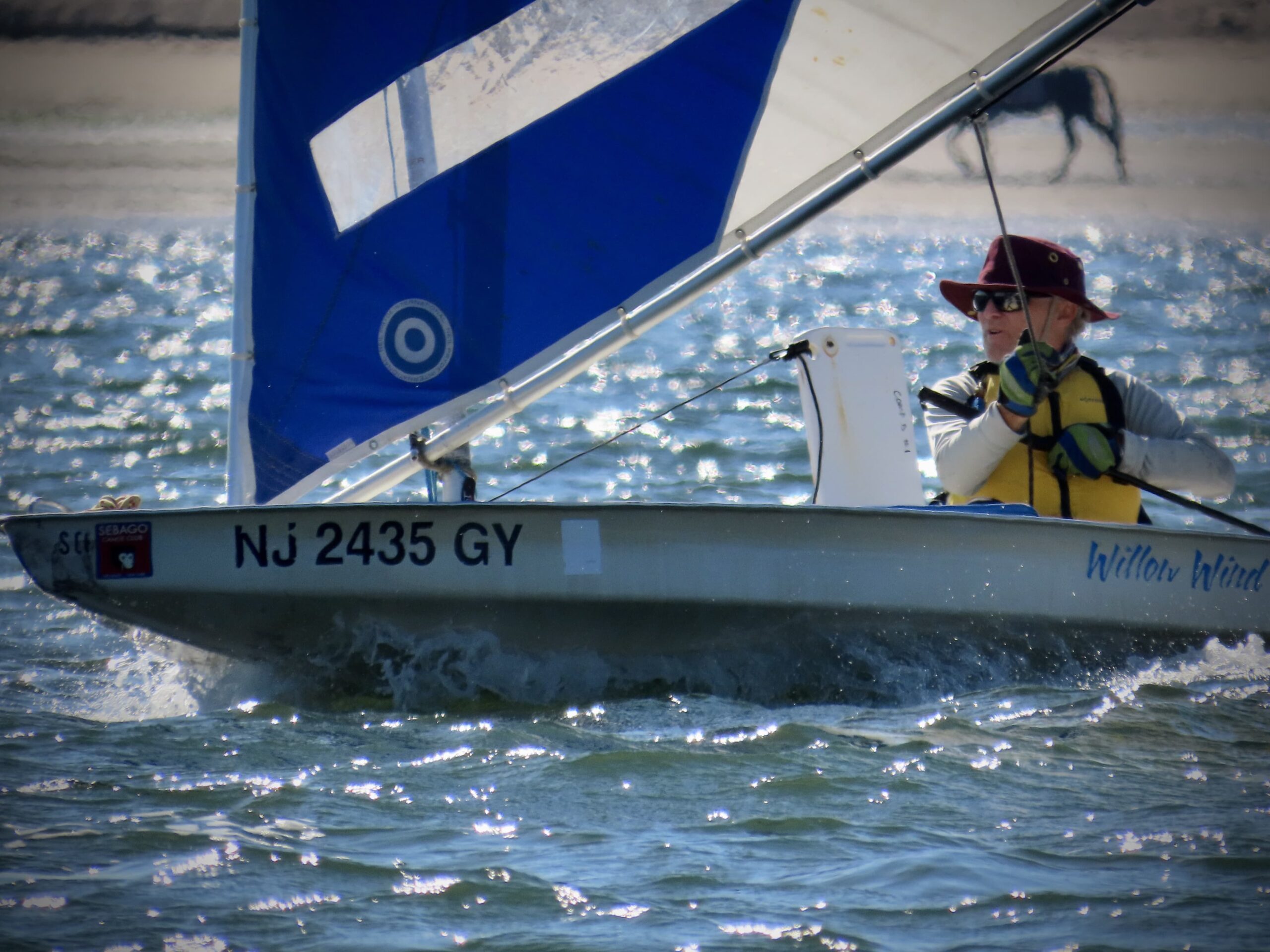
IN THAT PIC: Dyer Dhows rigged up and ready to..? Not sure if they’re about to drop in or if some cold sailors ran in to warm up. I remember clearing snow off the boats before rigging and splashing back in the day. Pic from Mamaroneck Frostbite Association’s site.
Dyers are NOT self rescuing. Back in the day, the chase boat would come rescue you and drop you off at the committee boat. That was a houseboat with a wood-burning pot-belly oven for heat. Wring out the wet clothes, warm up, and go back out. After bailing out your swamped Dyer, of course. Never again for me. I’d rather get the exhilaration of a fast dinghy, and have a good chance of a “dry capsize” where one jumps up on the rail and never actually gets wet. Most dinghies people race are self bailing, meaning water that gets in goes back out on its own. That includes the Sunfish, which is arguably an inefficient design, but it works – and it’s fun and fairly forgiving. That said, it’s harder to right one when it does flip, but at least it’s self bailing/rescuing. At that point, you might want to brace yourself thusly…
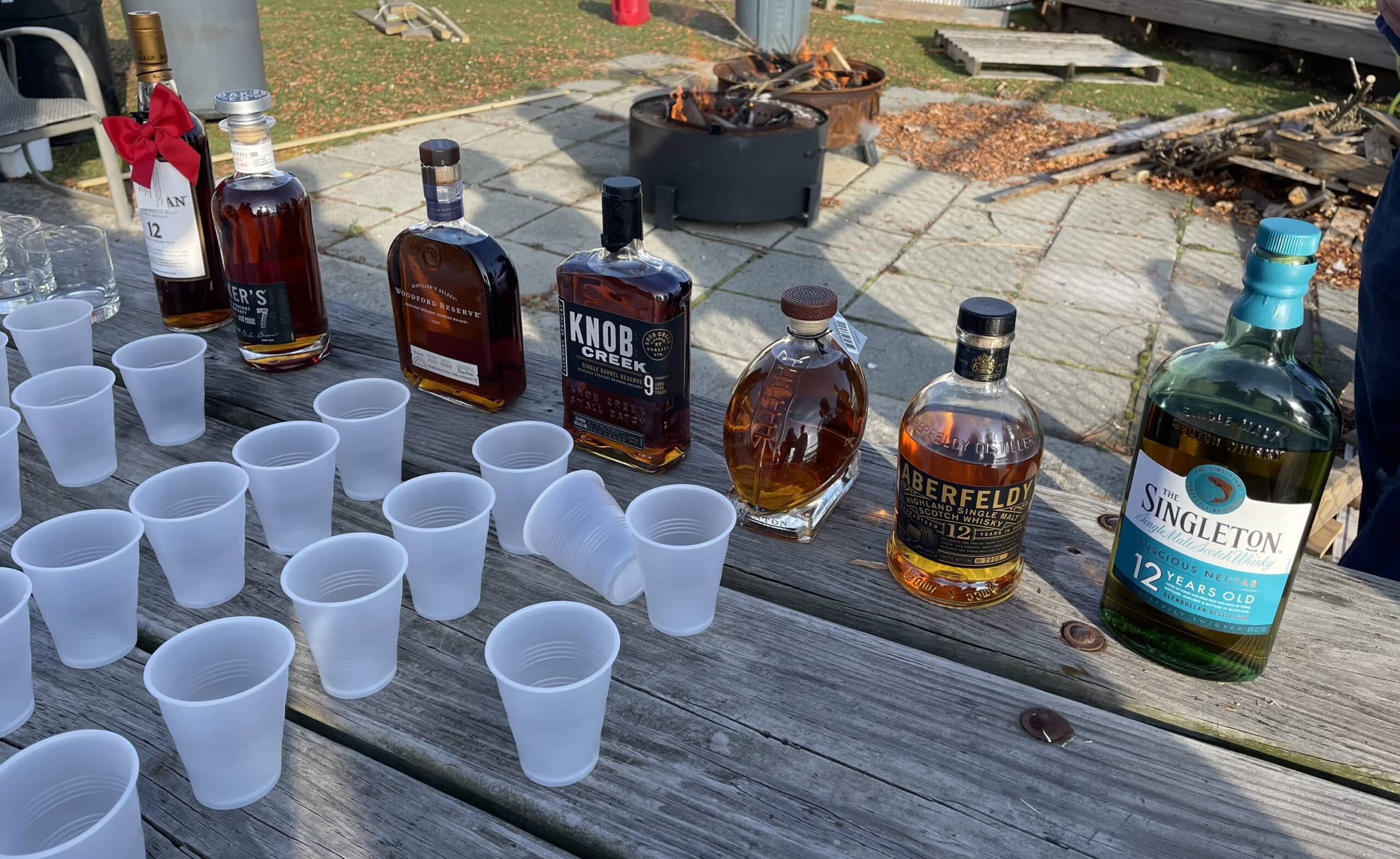
IN THAT PIC: fire (in background) and firewater in front. Whiskey tasting at the Miramar Yacht Club (home port to New York Sailing Center).
Why don’t we “frostbite” on the keelboats from the school? Well, we will! We’re going to go out from time to time this winter when weather allows. But, it has to not be actual frostbiting weather. That means seasonally mild temps and winds. So, it will be fewer and farther between than a typical frostbite racing program, and no racing. Just one, maybe two boats out with a few people having a good time. Fill a flask with the firewater of your choice; just don’t drive afterward.
How to get in on that? Hit us up to be included in an e-blast about it.
Want to do true frostbiting, with the racing and the cold & wind sometimes, and the potential for getting wet? Here are a few places to consider…
Mamaroneck Frostbite: a single-purpose seasonal organization that goes way back. I used to do this from 1979-mid 1980’s. They race Dyer Dhows as do some other clubs in the region. Not surprisingly, they’re in Mamaroneck, NY.
Cedar Point Yacht Club: a year round racing club in Westport CT that encourages newbies as well as seasoned vets. They have a frostbiting program. Details not on their site (at least nowhere I looked), so go to their site to contact them. They race Lasers and RS Aeros.
Centerpoint YC Frostbiting: CPYC is a year-round membership club with a frostbiting program in the ‘off’ season. They’re on Long Island’s North Shore. They race several classes of dinghies: Lasers, Penguins, and JY 15 sloops.
Weather and whether… that’s the continuing conundrum. Just go out and do something.
…but they’re fixing that part of their blog piece, done with GoDaddy, about our family history teaching people how to sail.
GoDaddy teamed up with Name.com at some point, and to help pitch the .club domain extension, they spoke to us. We use one ourselves; it was part of a re-branding and SEO campaign. Got the word “club” into the domain name that way; that was to be more relevant to those searching for sailing clubs (as opposed to just schools). We’re both, although we now refer sailing club clients to our host facility, Miramar Yacht Club, so we can focus just on instruction.
No, we’re not called “New York Sailing Club.” That’s something else. We are, as you know, New York Sailing Center. How funny (and f@$%ed) is it that Name got our name wrong?! But, it’s really not a drama. Perhaps by the time you opened this, it will have been fixed. The link was correct, and they basically got the interview part very right.
So, here it is! A few very minor details aside, this is what I told them, and this is what they wrote. Here you go.
For Stephen Glenn Card, the New York Sailing Club isn’t just a rental boat business for tourists who come and go. Instead, the boutique boating school in southern Brooklyn is a family legacy dedicated to educating the next wave of ocean-lovers about the true art of sailing.
“The idea is to properly teach people how to sail so that they’re truly able to take out the boat they learned on without us,” says Steve Card, owner and operator of NewYorkSailing.Club.
It all started in the 1960s when his father, Glenn F. Card, an ad executive and licensed captain, bought a small sailboat. He didn’t have time to use it so he put an ad in the newspaper to rent it out. “Demand was robust,” says Steve. “So much so that he got another boat, then three. It boomed. So, he started Sail-A-Season.”
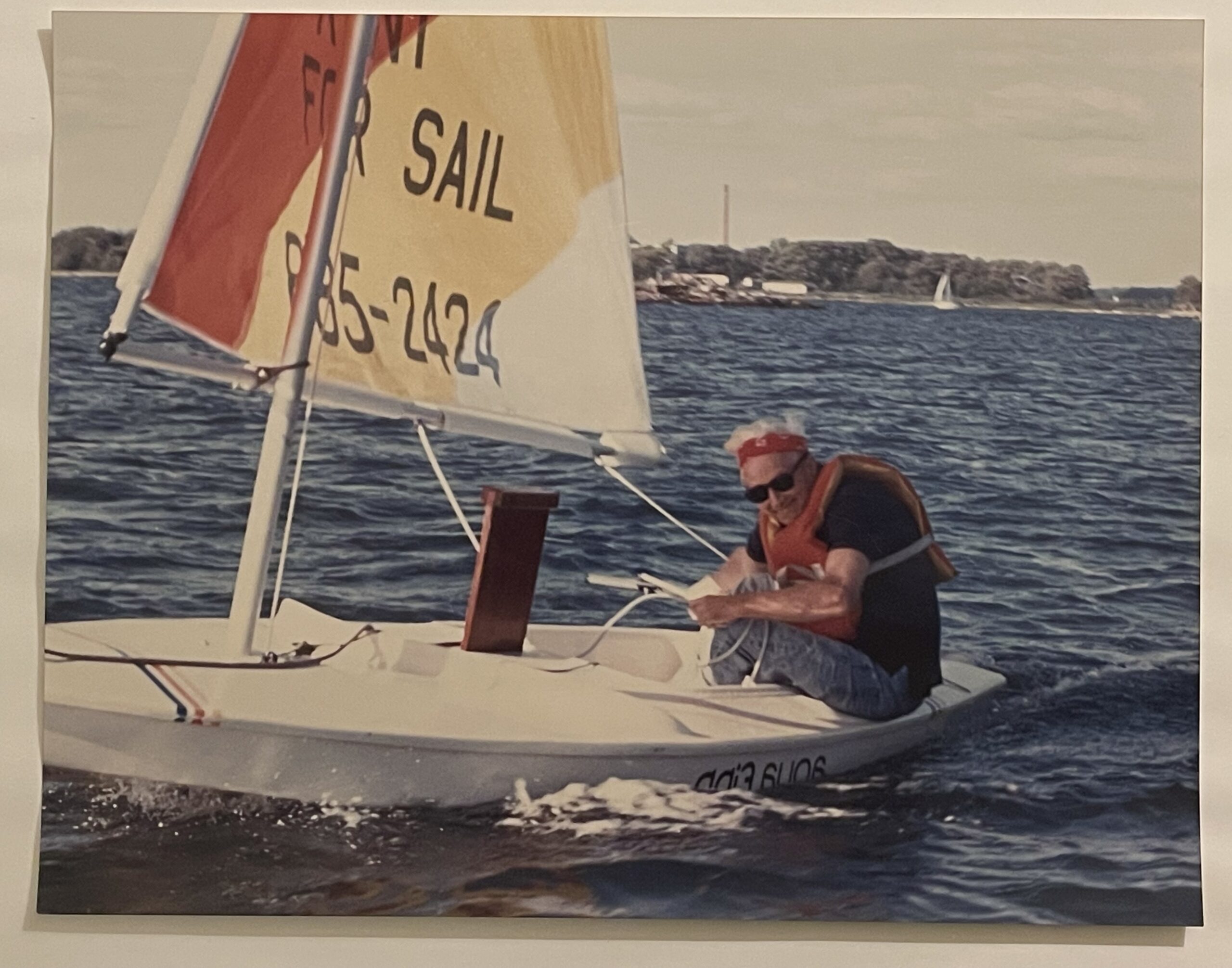
IN THAT PIC: Pops back in the mid ‘90’s, enjoying a spontaneous sail on a knockoff of a Sunfish. Both Pop and I started dinghy sailing relatively late in the game, and loved racing them.
The business was modeled as a fractional sailing plan; and it soon began to take off and compete with Glenn’s day job. “He was an original Mad Man!,” Steve recalls of his father. “So, he added a sailing school, gave up the day job, and put his copywriting skills to work on his own business, New York Sailing School was born.” Over the next decade Glenn would retire and sell the school. (Ed. note: Dad had the school from 68 to around 87.) After he passed away, Steve felt compelled to act on his own passion for turning rookies into skippers. “I started my own school and followed in his footsteps,” says Steve.
The New York Sailing Club—which also coaches people on how to charter, buy, and even race in Brooklyn, is based in the Miramar Yacht Club, far from the crowds of Manhattan. In 2003, Steve launched a new set of experiences: sailing trips in the British Virgin Islands, where sailing enthusiasts can escape the wintry Atlantic. By 2006, he expanded the sailing trips to Mediterranean destinations like Italy, Greece, and Croatia. “Students get a great balance of training and vacay on these trips,” Steve adds.
IN THAT PIC: Pop took this shot when I was a wee lad. He must have shot it from the port (window) of the aft cabin on a Virgin Islands cruise with mom. That meant she was steering.. and that meant she was pissed! Old and faded, but the subject still stands.
The business continues to grow and evolve, but Steve admits the market has gotten choppy with more competitors. “We’re fighting against businesses that give shorter courses for less money,” says Steve. He advises true, aspiring sailors to invest in accredited and quality schools. “Pay a little more, travel a little farther, and actually learn how to sail,” he says. After all, when it comes to sailing the seas, safety is critical.
Steve has advice for entrepreneurs who want to take their businesses to the next level. “Make sure you can wear the hats properly, and be ready to adapt and reinvent yourself,” he says. “Technology will change; the client base will change. Be ready to change with it.”
For Steve, the changes in the competitive landscape also called for fresher marketing strategies. Up until the 1990s, the family would largely rely on classic ads in the New York Times’ Weekend Section. But with the dotcom boom, he knew it was time to launch startsailing.com in 1998. Just a few years ago, he decided to rebrand with a shorter name, new logo and website. The creativity behind the next iteration of his business website was largely driven by his own clients, who happened to be experts in branding, web design and SEO. The tech-savvy customers also advised them to choose name.com as their registrar.
Their original web address now redirects to their new .club URL, NewYorkSailing.Club. “Our .club domain was part rebranding and part SEO,” he says. He says any club-oriented business should opt for the TLD. “My clients thought the domain extension would be picked up favorably by Google as it did for others, and we went for it. At the time I wanted to better emphasize our club sailing plan.”
Choosing Name.com as the web registrar made it simple for Steve to further establish his business’ online presence. “Challenges are mostly how many hats one has to wear,” he says. “Our domain registration process was easy and we’ve had no difficulties since.”
IN THAT PIC: look familiar? I shot that in May on our most recent BVI trip. Inspired by Pop’s shot above. Not as good as his, but a nod to pop nonetheless.
What is it like to carry on your family’s local legacy in sailing, and train the next generation of sailing instructors? What’s the most important lesson you hope they take with them?
After my father sold his school, I took over the marina business. But the school was the true family tradition. I’m very proud and satisfied to have carried on the business, but almost better still, recreated it … My father had mostly very good success with finding and mentoring excellent instructors. I was even pickier, and slower to bring people on board. That kept the standards higher. Eventually, I chose and trained new instructors who had the potential to be great at it. So far, I’ve had a 100% hit rate on that.
I am most proud of pursuing a second branch for the school that no one else was able to make work before: Sheepshead Bay, Brooklyn. So, to copy detractors of Joe Biden, “I did that!” My dad couldn’t do it, a chief competitor failed more recently, I pulled it off, and it’s the future of our school now. Very proud of this.
IN THAT PIC: me racing an actual Sunfish dinghy in the Sebago Fall Series, Jamaica Bay, Brooklyn And, yes – that’s an actual horse on the beach!
What’s it like to run a business in southern Brooklyn? How do you attract tourists away from the crowds of Manhattan?
While tourists might well enjoy taking a tour of the NYC waterfront via the Circle Line or the Staten Island Ferry, it’s these very things—plus the Fast Ferries, cruise ships, barges, etc., —that make sailing so difficult and disappointing in the Hudson and East Rivers as well as New York Harbor. We cater to NYC locals as well as from many other parts of the New York Tri-State area. Brooklyn continues to evolve as the hot area in NYC. As for running a business here, it’s amazing. It’s a very inclusive and hospitable community.
I know you offer everything from sailing lessons to evening sails. What’s the most unique or popular service, or what do customers seem to enjoy the most?
We have two specialties that other schools do little of. First, we do a lot of private lessons, both on our boats and on those owned by our clients. We can sail and teach on anything, whether it’s high-performance racing dinghies or large cruising yachts. Secondly, we offer navigation courses on Zoom. When the pandemic hit, I jumped on that as a solution for our coastal navigation course. It was popular, and it works: it’s almost as good as being in the room with the students, and it’s vastly more convenient. We keep the same small group size for individual attention.
What’s the most beautiful place you’ve sailed and why?
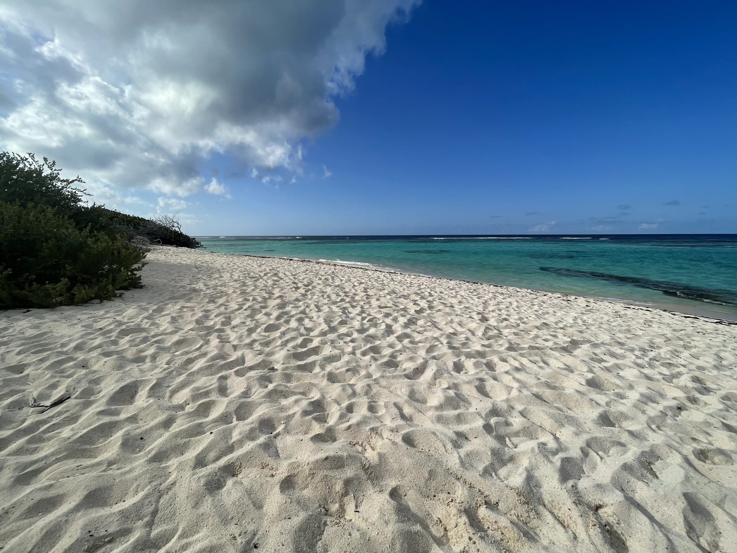
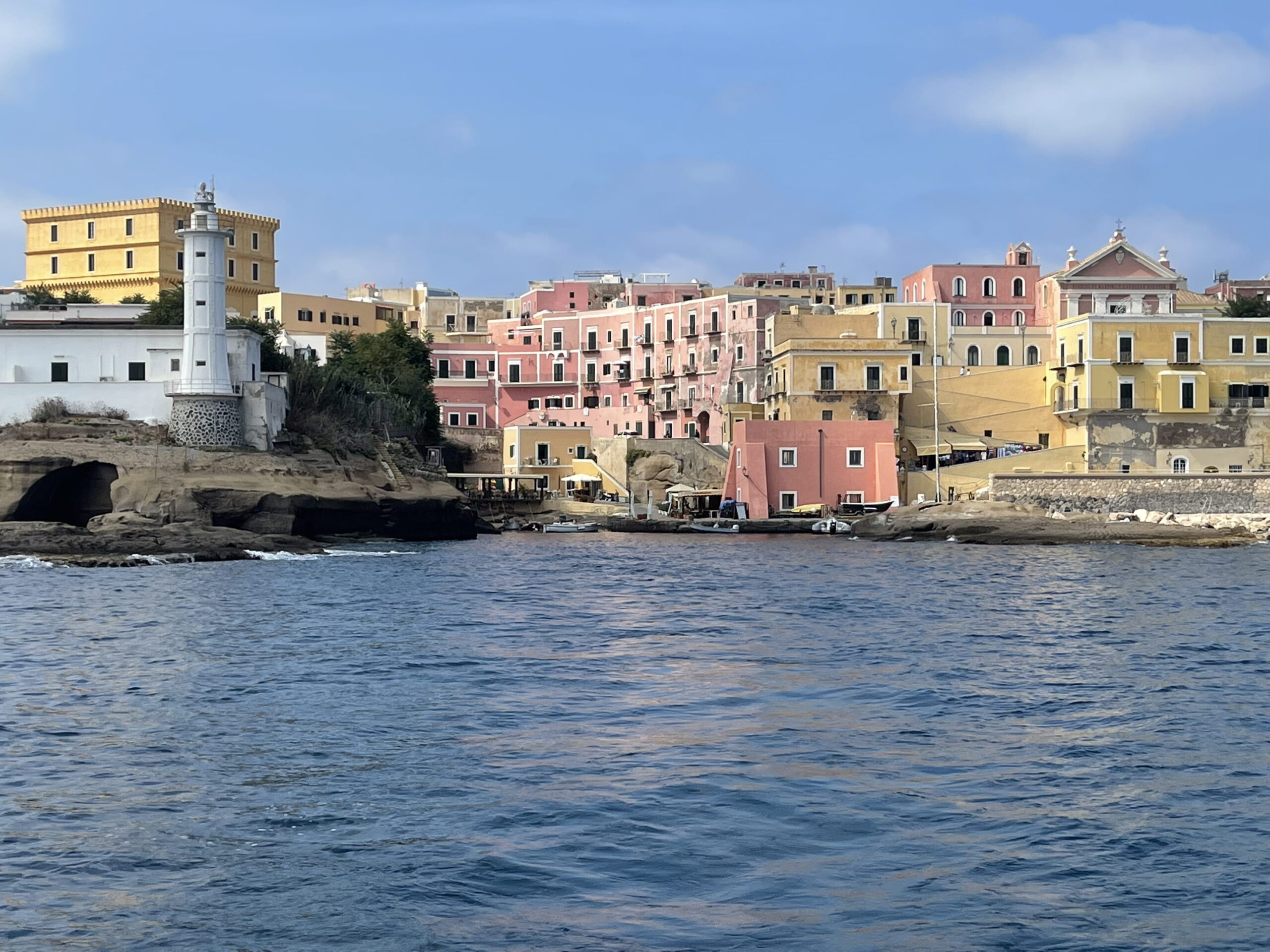
Hard to pin that one down. I’d say Anegada in the Virgin Islands, and Ventotene in Italy. Both are a little remote in their respective territories, and both are worth the extra time to get to. Anegada is a completely stunning and unspoiled Island that’s like the Bahamas in the BVI. Ventotene is a ruggedly beautiful outpost off the Golfo di Napoli. Old Roman Harbor is just that: ancient, with few modernizations. Walking up and around this island is a must, along with the amazing beaches.
IN THAT PIC: Anegada in all its splendor. The north shore beaches are world class here, with excellent snorkeling, SCUBA and just plain swimming.
What’s the biggest obstacle you’ve overcome as a business owner?
The weather. We’re a strictly weather-dependent, largely seasonal business. Weather can make or break us, and climate change has been catching up with the sailing industry. We moved to Brooklyn partially due to this, as the weather and wind are better.
On your homepage you have a section titled “Blog: Recent Rants” which I love. Why is blogging important to you as a business owner?
Blogging helps me keep the site fresh, but also lets me speak my mind. I like to include educational and public awareness content, and I like to write my way. I don’t give myself full creative license on the (mostly) static pages of the site. In the rants, I can ramble and roam!
IN THAT PIC: off Old Roman Harbor, Ventotene. Expand the pic to see just how tight the entrance is, and the sailboat lurking around the corner (revealed only by its mast)! Two people are on a zig-zagging staircase making their way up to the piazza.
What’s your top advice for others who lead a long-running, family business?
Be ready to reinvent yourself.
What’s the most important thing people, especially those new to sailing, should know about sailing?
The web has made more and more activities available to everyone. Explore options on the web and then get out and try them! People are constantly amazed when they find our site, and get a flavor of what it’s like to learn and continue with sailing, including how accessible it can be. Sailing has a reputation of being expensive and exclusive, and many organizations have been helping to change that. The internet is integral to this mission.
BELOW: One last shot…
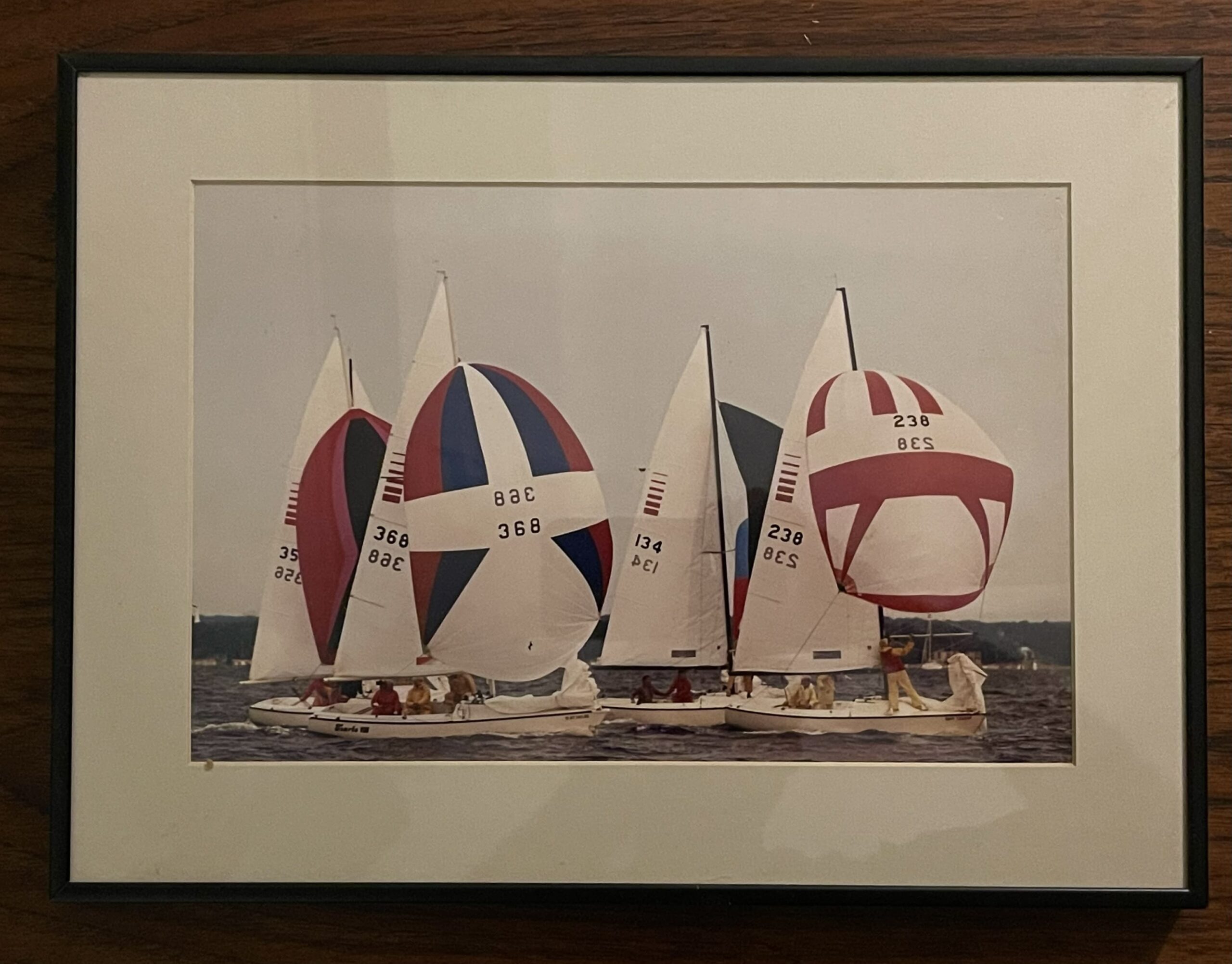
Pop and I leading a pack after rounding the jibe mark at a Sonar regatta on Long Island Sound in the 1980’s. His school introduced Sonars to sailing instruction and he was a large dealer for them. Now, I’m teaching on the boat that inspired the Sonar: the Ensign! I went old-school, and I’m loving it.
IN THAT PIC: Pop and I on 238, with a 3rd as crew. Pop’s steering and I’m handling both the sheet and guy for the spinnaker. John just end-for-ended the spinnaker pole. We led that pack, but not the fleet.
But could I figure out how to sail a Sunfish for the last race day of the season at Sebago Canoe Club?
Almost the entire fall series at Sebago was lost due to terrible weather. Orignally scheduled for a month or so worth of Saturdays, only one day turned out to be sailable. But, October 28 – the last day – looked so promising it was spoo-kay…
IN THAT PIC: two Sunfish class dinghies doin it. Fun colors are part of the experience, at least for basic/practice sails – which are often enough to win races. Sebago Fall Series, only day of racing this time due to freakishly bad weather. This and all photos below: Chris Bickford, member of Sebago Canoe Club.
No Halloween colors represented on sails, but some nice colorways nonetheless, including the one I picked off the rack. Might have been a basic/practice rig rather than a ‘racing’ sail, but as I discovered, it doesn’t mattah. Not much, anyway. These are simple boats that challenge you to sail them well, not trick-o-treat them out. And, a good start always has and always will be key to consistent success in short course races.
I showed up early to grab the Laser I was familiar with. I didn’t expect to be on a ‘Sunny,’ as some call the Sunfish: one of the world’s most popular and important boats: with a well attended Word’s, in the Pan Am Games, and the mainstay sailboat class at Sebago. A few of the key club members were there before I arrived. Tracy asked if I wanted to sail one, in which case we’d go one-design that day. I said, “I’ve never sailed a Sunfish in my life, but sure!” I love one-design: all the same boats on the line, so no wondering who sailed better and who really won. Hadn’t done it in forever either.
IN THAT PIC: Collette and Isis having a laugh while rigging a Sunny before the racing. This was on the grounds of Sebago Canoe Club, which we’re all members of. It’s a cooperative that some members describe as a community garden with a dock. But, it also has a large fleet of kayaks, canoes, and sailing dinghies members can use after getting checked out on them. Safety first!
So, I started picking parts and gear out of the locker, and Max kindly helped me put it all together. Months ago, at new-member orientation in June, Paul gave a rigging and sailing demo of the Sunfish. I could tell he knew what he was doing and saying. Several veteran members of the Club wanted to give their two cents as well despite it being Paul’s gig. I ignored them and listened to Paul. But, I didn’t get around to trying out a Sunny myself so forgot his tricks. Max fixed that.
And Paul was racing today! He comes down once in awhile from Toronto to grace the area with his presence. I figured Paul would be one of the sailors hardest to beat in the fleet today; he proved me right. (He races Sunfish and Lasers and travels around to do it.)
It was so summery-warm on the way out I was sweating. Forgot about it once out in the Bay with more consistent wind. No wetsuit despite late October, as it was too damn warm. Water wasn’t so cold after all; hard to not get feet and butt wet in a dinghy and didn’t exactly freeze up. This weather was a gift.
IN THAT PIC: RC duty. Race Committee has to be staffed somehow. Everyone participating in a spring or fall series has to chip in. This is the ‘Canarsian,’ a home-made wood boat (built right at Sebago) with a (factory built) Suzuki outboard motor.
So, after the Sebago Cup in September that I wrote about in the last Rant, I was wary of not being on my game for the start. Only had the one back in September as it was one distance race of around 7 miles. This time? A bunch of short course races. That meant a number of opportunities to get a good start, but also that each race’s result largely depended on those starts. So, I perused the starting line to see where advantage might be gained. I made a plan for how to time the start and have some latitude to react to competitors who could wind up in my way, possibly with right-of-way.
First race: I decided on a windward (right side of line) to mid-line start. That would give a little more leeway for timing and dinghy-dodging, and also give me more freedom to tack (cross the wind and sail the other way) in response to wind shifts or to clear my air from competitors. I visualized my out-and-back path, focused on timing, and executed.
IN THAT PIC: a tight start. Isis is in the foreground, hiking flat out. I’m sitting up in the colored Sunny. Not sure which race this is, but probably the one I’m describing above and below…
BAM! On the line, at full speed, near the windward end, at the gun. I pulled ahead and soon after tacked to cover the boats that had started going right, which was the call due to a current setting left and the fact that the first mark, ‘windward’ or upwind, was a little off center to right.
I led that race the whole way, and finished first. Wow! Only my second actual race in decades, and my first time in a Sunfish. I was “starting to believe.”
Turns out… I rounded the downwind mark the wrong way. Didn’t affect anything; no advantage. But, it was the wrong way. I was advised of this casually by the RC (Race committee) when approaching the finish line. Oopsie…. So, I said, okay, toss me from the race. Not worth sailing back to round the correct way and dodge oncoming boats only to officially finish last. They scored me DNF (Did Not Finish). Might as well have made it DAF. (First letter is for Dumb; you can figure the rest out.)
Then it came back to me: that was my Dad’s and my MO. We were infamous for rounding the wrong way, or rounding the wrong marks. Keeping up the family traditions!
IN THAT PIC: I lead the fleet, and as I only did that once, this is that race. I’m looking back at Isis closing in on me, but this time, she didn’t make it. She did the next time…
Next race: thought I was doing okay at the start, but then just after the gun, I saw two or three boats cross fast at the leeward end on port tack. Done. They probably timed the wind shifts well, and they were off to the races. I stayed left for a bit to try to clear my air and look for more wind; only chance to recover. I wound up way back in the pack. Don’t remember my finish but it was close to last. (Someone always has to come in last, of course.) Oh, well. More races to come.
Next race: nailed another start; rounded first mark in 2nd place. But, I dropped a position as Isis expertly overtook me at the downwind mark after we debated whether she had an inside overlap in time (2 boat lengths before the mark), and therefore rights to room at said mark. I said no, you’re clear astern. No problem for Isis; she went wide of me and executed an expert mark rounding. I flubbed mine. She was in the zone, and got just past me at the starting line. I like a tight finish, so didn’t mind that she nudged me back to 3rd.
IN THAT PIC: Isis and Tracy in fine flat form. They’re both active racers, and both have the top tier qualification (4) for all the common boats in the fleet at Sebago.
Next race? Dip start! Dad’s go-to, and a favorite of mine. Come in from upwind of the starting line (wrong side), and dip down into a hole with good speed and clear air, plus room to maneuver. Risk; everyone downwind of you has total right of way. I was correct in that there’d be room. But, apparently, I was over the line early; they said so, and while I was convinced I was not, as I’d been looking back and forth over my shoulder to confirm the bearings, they of course had a better view and no bias. So, had to go around the end which costs a lot of time and distance. (Didn’t realize they only require dipping back down over the line, but that is often impossible with other boats on either side of you.)
And then, another revelation: Yo-Yo! Dad, especially, was a Yo-Yo. Up and down; consistency wasn’t a concept we seemed to sail by. I was being a yo-yo, yo! We both kept it more together when there was a regatta to be scored, but in “any given Sunday” frostbite racing, for example, we (he especially) ran up and down that yo-yo string.
IN THAT PIC: the infamous Paul up close in foreground; probably about to nail a start. I’m close to getting mired in the mess at the other end of the line, but this is probably the start where I got right on the line and overdid it, getting called over early and blowing it.
So it went, and we got 6 races in. Abundant sunshine; comfy temps; 12 boats on the line! That was all but unheard of at Sebago in recent years. They have closer to 15 Sunfish that the Club owns, plus a few private ones, but it’s very rare to get that many people choosing to sail in the same boats on the same day. Maybe this glorious day will prompt more of that.
Plus, there’s some kind of riding stable nearby, and we were treated to small groups of horses being ridden along the upwind shore from time to time! Special sight…
IN THAT PIC: horse HO! YUP! That’s a horsie behind the Sunny I’m sailing. We saw many riders that day. And, apparantly, my boat was named Willow Wind. Love it!
I don’t have much experience at Sebago yet, so I’m not sure what’s common. That said, it seems that women participate as much as men. This race day was a fairly equal mix. I like to see that in any sport or activity in which it makes sense (as opposed to full contact martial sports, for example). Some sailing classes require heavy and strong people to sail them, so they’re men-only on the race course. Classic example: the Finn Dinghy, the former Olympic heavyweight singlehanded class. It used to be the only singlehander, but to accommodate smaller athletes, they added the Laser. Even the full-sized Laser is too large for too many women, but the Radial and the one smaller than that (forget the name/size) have their own starts and women race against each other. Co-ed sailing is increasing as well, including in the Pan Am Games and the Olympics.
IN THAT PIC: Collette and another woman in between races. Didn’t get her name! But she makes another appearance below – look carefully to see why. She was in the lead in one race; didn’t see if she kept that lead and bulleted (won).
My takeaways on the Sunfish? It’s great! I didn’t expect to enjoy it as much as I did. It’s simple, forgiving, and lets you focus on just sailing the boat well and placing yourself in relation to your competitors. It’s the great equalizer. I had a dubious practice/play rig; others had ‘race’ sails with more shape and more adjustments. But, it didn’t seem to make much difference if any. Maybe at much higher levels of competition, but not for pick-up local racing on very short courses.
IN THAT PIC: Carla, in the lead in a race she won. Carla is a new member like I, and races in several locations, including Mamaroneck Frostbite (which I did decades ago).
Sailors of very different physical proportions can be competitive together in a Sunny fleet. Part of that is the sail being lower, so there’s less leverage to lean the boat over and potentially flip it. It has the same sail area as a full-size Laser rig (75 v. 76 square feet), but the overall height of the sail is lower, and much more of it is way further down due to it’s very triangular ‘lateen’ rig. Tech terms: CE be low. Sure, it’s less efficient. But if you’re sailing against other Sunfish and not full-rig Lasers, who cares? And it’s a really fun boat.
IN THAT PIC: Why not bring a friend? Look closely at the companion in the boat. Seemed to enjoy it as much as the sailors.
If sailing a Sunny is what it takes to get more of the same boats on the starting line, then I’m all Sunny Dee-Lite. And I’m sure I’ll choose to take one out once in awhile for more casual bopping around in a sailing dinghy when it’s just about time on – and super close to – the water.
IN THAT PIC: I’m heeling the boat well to windward on the downwind leg of a race. This is to get the sail up higher in the wind column (more wind) and also keep it more over the boat for balance. Makes for a wet butt, but that’s part of the game.
A recent shark attack in the Rockaways not far from where we teach you how to sail drives the point home, close to home.
IN THAT PIC: One video segueing to another from Scott Fairchild’s feed on Insta. That/those are great white sharks in California.
Last Monday evening at 6pm, a woman went in the water off Beach 59th Street in Far Rockaway. She was close to shore, but alone. She screamed, and lifeguards went to help. She’d been bitten by a shark and had a serious wound to her thigh. The New York Post took the sensational route, of course, and also published a lame account of the attack where someone claimed the woman lost approximately 20 pounds of flesh. That would have been her entire thigh and she would have been dead before she could have received treatment. Desapite that being debunked they have not corrected it. They also published close ups of the woman being treated on the beach. Not gory; shows some blood but mostly her being treated and also good samaritans holding her head and hand. Good shot from that perspective, but won’t reprint it here. Go find if you must.
She was brought ashore and a tourniquet was applied. She wound up in Jamaica hospital in serious but stable condition and was expected to not just survive but make a full recovery.
But, that was close! Had she been further out, and/or lifeguards weren’t nearby, she would have had a high risk of dying from loss of blood and shock.
“Yes, but…”
A large, perhaps overwhelming majority, of shark attacks are survived. Most bites are from small sharks and make minor injuries.
It’s scary nonetheless. It was a serious attack. And, there have been a rash of shark bites and all kinds of sightings in Long Island waters in the past year or so. Numbers of sharks seem to be on the rise.
“Yes, but…“
Same diff. Florida is historically the shark attack capital of the world, with a proportionally very large percentage of attacks. Vast majority are minor bites by small sharks feeding on fish.
But but… I don’t WANNA get bit by a shark!
“Yes, but…“
No one does. But the odds against it are insanely in your favor. Compare the number of attacks/bites documented each year to the incalculable number of times people go in the water with the sharks. Total documented attacks? Hovers around 100. (Undocumented attacks probably tip up the number incrementally, but there’s no reason to suspect multiplication is involved).
IN THAT CLIP: surfer paddling directly over a great white shark in Cali.
Also: think about when to get in the water, and when not to, etc…
Don’t swim at night. Dumb and Dumber didn’t even do that.
Don’t swim at dawn or dusk. At least as bad.
Don’t swim in the mid to late afternoon. This is a trigger time for predatory fish to feed, in my lifelong experience as an angler, and it happens to be when many attacks happen (probably more because more people enter the water, but still…)
Don’t swim alone in waters where sharks might be. Okay; they might be ANYWHERE. So, don’t swim alone where sharks have been seen recently, or where there’s any history of attacks and/or dangerous species being seen.
Don’t swim when small fish are being chased by birds or other fish, or where where gamefish like tuna have been coming close to shore, even if they’re not there when you go in.
Don’t swim when there’s any chance you have a cut of any size that could bleed, or if you’re menstruating.
Don’t swim when the water’s particularly murky.
Don’t splash around frantically. If snorkeling, no need to smash your fins down on the surface with each kick. Super inefficient anyway; keep fins in water to push water!
Can you get through your natural life without being bitten by a shark if you break some or all of these rules? Yes! You probably won’t get attacked if you break them all.
“Yes, but…“
She did. She swam alone, and shortly before dusk. Don’t know if any of the other rules applied. But, it’s the first documented attack in NYC waters since at least the 1950’s. And, the near-ish attacks on Long Island were all minor.
IN THAT PIC: another video montage from Fairchild. Swimmer and surfer basically on top of great white sharks.
I consider the fear of attack to be both irrational and rational. I’ve been fascinated by sharks and shark attacks since I was a boy. My dad took me to the South Street Seaport once and, of course, no visit anywhere ends without a stop at the gift shop. I took home a book: Shark: Unpredictable Killer of the Sea, by Thomas Helm. Lost the original but replaced it on Amazon…
Great book. One man’s perspective on sharks, shark fishing, and attacks, with some personal anecdotes. One of them both reinforces and destroys the subtitle. He was stationed in the Pacific during WWII. Somewhere there was a lagoon encapsulated by a fringing reef. His unit was tasked with disposing of outdated grenades. They decided to fish with them. They went out in a rubber raft and started tossing grenades in to stun fish.
BOOM. Up floated many dead fish. BOOM. Again. he-he.
Eventually, sharks came to pick up the scraps. So, why not blow up the sharks? They started tying grenades to fish, pulling the pin, and tossing them so if a shark went to grab it, head blown off. Nasty; wrong. Dumb. But, the author knew it by the time of writing long after and was admitting, not bragging.
Then, they started tossing the fish in immediately after pulling the pin. One shark took the bait and swam toward the raft. Ooopsieee…..
BOOOOOOMMMMM!
Raft flipped and tossed them all in the water – with that much more fish blood in the water.
They all swam back to shore unscathed. So, the sharks didn’t see them as potential prey, despite what must have been some frantic flopping about and plenty of blood in the water already. Should have been… shark bait.
“Yes, but…“ No bites.
Unpredictable. Except, maybe, they’re not unpredictable, indiscriminate killers? Maybe they bite when they’ve rarely mistaken us for normal prey, or in more rare cases, when they’re simply desperate to feed or otherwise thrown off their games?
My own experiences with sharks…
Seen a few while snorkeling. First was in Australia on the Great Barrier Reef. White tip reef shark. It was lying on the bottom breathing from the current without swimming. The snorkeling guide swam down toward it to spook it into moving. It grudgingly did so, and lazily went in a great circle while no one but I saw it plop down in the same exact spot to resume minding its own biz. Everyone else had swum away. My treat.
Another time, found a decent sized lemon shark minding its own biz in the Tobago Cays of St. Vincent and the Grenadines. Video’d it with underwater camera (point n shoot in a good case). It spooked and swam further away quickly, then resumed a lazy swim. I got good zoomed in footage. It’s up on our YouTube right now! What I DIDN’T see at the time was the other shark that was what spooked the lemon. THAT scared me! Different species. Never found out what.
Saw others snorkeling in the BVI. One time, a guy was sitting on the bottom minding its own business. Wasn’t a nurse shark; didn’t match another species I could think of. Started approaching to ID it. Then, I thought better and went away.
On our most recent BVI trip in spring of 2023, clients were snorkeling off the boat in an anchorage. They got my attention: wanted a ride back in the dinghy. They’d seen a relatively large shark and didn’t want to fool around and find out. At least one of them didn’t. The other, when advised and asked, wanted to stay in and try to see it. Only problem is it had seemingly spooked when the first guy saw it and disappeared. How large? Around the size of the dinghy. 10-11 feet.
Drones are the new rage, and they reveal how often we’re actually swimming or surfing with dangerous sharks swimming amongst us. Enter Scott Fairchild, whose Insta account is so revealing. And, they’re being used to look for sharks by beach and park patrols to make swimming even safer.
And now for a few words and images from someone other than me!
Great montage in Scott Fairchild’s Instagram account…
Actual clockwork – the works that solved the problem of how to sail across an ocean safely by keeping proper time for navigation. And, these clocks from the 1700’s are still ticking!
IN THAT CLIP: Harrison’s four timepieces that revolutionized navigation and long distance sea travel.
I visited the Royal Observatory in Greenwich, England this month. Been on my list since I first read “Longitude” by Dava Sobel, about the English crafstman and inventor John Harrison. I’ve written about it before, but now I’ve seen it.
“You have to see it to understand. Now I’ve seen it.”
The Dragon Queen, Game of Thrones
(I also saw the dragon motifs in Wales, and got some great drag swag, but that’s another story from the same trip.)
Harrison’s clocks revolutionized sea travel and have withstood the test of time. It took him most of his adult lifetime, partially because he was a self-sabotaging perfectionist, but he solved the problem of his time: how to determine longitude at sea. His timepieces were the first chronometers, or very accurate time pieces that would work for extended sea voyages without adjustment or maintenance. And, he won the incentive prize offered by Parliament: 20,000 pounds. That translates into roughly $7 million when adjusted to today’s value.
IN THAT PIC: His first chronometer clock, H1. Kept good time near-coastal in Europe.
Why was this a problem to begin with?
To determine longitudinal position at sea (east/west), one needed to know the time at the home port of departure (now Greenwich, England, or GMT for all) and compare it to the local apparent noon (sun at its zenith).
To do that, one needed an accurate time piece.
They existed on land, but none of the day could keep time at sea due to the motion of the ocean, as well as changes in humidity and barometric pressure.
Until the problem was solved, vessels were constantly at risk of delayed or premature arrivals, getting lost, or worse, running aground. That last eventuality was the straw that broke the stiff upper lip of the land: a small armada was lost off the coat of England due to poor position reckoning.
IN THAT PIC: H2. Tried to sole some problems; he found another. NEXT!..
The detailed history is best left to Dava Sobel, but suffice it to say it that this wasn’t an easy affair. Here’s a super-short summary.
In 1714, Parliament created the Board of Longitude and offered the prize.
In the 1720’s, Harrison created his first clock. It was huge, unwieldy, and elegant a/f – so much so that a fancy-lad clockmaker in England makes stunning replicas.
It worked well enough on a proper sea trial, and it was duly recognized by the Board, but there was room for improvement. A small sum was paid with the promise that another improved clock would be built.
IN THAT PIC: H3 Not good enough. The can of worms, they squirms…
It took three more iterations, decades of time, and some political jockeying to get it done…. but the fourth time was the charm. From a large machine, to a large pocket watch, Harrison created a consistently reliable chronometer and safe navigation was possible. Sadly, despite this accomplishment and also winning the king’s ransom of a prize, he died a bitter and broken man.
IN THAT PIC: H4. DONE. Kept accurate time from England to the Caribbean.
But, I was a happy fan at the Royal Observatory. I highly recommend anyone traveling to London take a side trip to Greenwich, which also has the Maritime Museum and the Cutty Sark. Easy on tube + rail. Harrison’s clocks might be the best part about the Observatory but there’s plenty more, including the touristy thing: standing on the Prime Meridian!
Again: read Longitude by Dava Sobel. Get the illustrated version. Fascinating and revealing. There’s also a Nova episode about it, and despite being a little campy with reenactments, it’s great. Sobel is interviewed in it.
We teach the basics of latitude and longitude work in our Coastal Navigation course, Start Sailing (ASA 105), including how to use lat/lon coordinates from a GPS to plot position on a paper chart. Old school blended with new.