Yelp helps level the playing field. In our case, being a very small business, and one where our talents don’t necessarily lie in web design, SEO, digital branding and marketing, etc, we need it. So, we’re very pleased to have just received this award of distinction from Yelp. Nice email to start the week!
We do well on Google, too. In fact, we have a perfect 5-star rating in their reviews.
We the People love Yelp. We use it to find things for ourselves. We compliment or critique, and sometimes just plain crap on, businesses and services we use that are on Yelp. And we at NY Sailing are out there and subject to the same.
We have 17 reviews on Yelp. All but one are 5 stars. (One is a 2-star, but still has some good stuff to say.) And they’re all legit: real reviews from real clients. Be sure to check out the ‘filtered’ reviews as well – the ones that Yelp’s algorithms deem suspicious and label as “not currently recommended.” They start at the bottom and one has to click twice to read them all.
As we’re deep in the throes of a cold start to the winter – polar vortex/arctic blast kind of cold – thoughts are somewhat removed from sailing. But not entirely.
While on the slopes enjoying fresh pow over the holidays, and warming back up to techniques shelved during the boating season, I was reminded of the concept of turn initiation. Don’t ski or ride? Don’t even sail yet? No problem – we’ll break it all down and maybe even get you stoked in the process.
Looks like this rider either tried an abrupt start or ending her last turn that way. Wasn’t there; can’t be sure. But it looks like she made a zig-zag of quick pivot turns in a that are on the right in pic. Her edge and bottom of board are a brake right now. Good if she wanted to stop quickly. How does that translate to the rudder of a sailboat? Read on…
“Turn initiation” is the technique used to get a ski or snowboard to go from flat on the snow to beginning a turn to one side. Anyone who can link turns on either kind of plank knows what I’m talking about. It’s like this: we make certain motions to suggest to the equipment that we want to turn instead of going straight. After it starts listening, we add more motion to shape and complete the turn to the extent we want. Regardless of what kind of turn we make, we have to start it – and eventually end it.
Same with boats! Techniques, and consequences for ignoring them, are different. Thankfully for sailing, there are usual no real consequences.
If you ski or ride, but are beginner to intermediate, it’s time to think about this again as you begin your snow sliding season. You experts out there don’t think much about it, but warm up your technique and self-critique as you get your form back each season.
These guys are about to go down a moderately steep trail at Killington in Vermont. Skiers have two planks. Duh. Translation to sailing? Twin rudders that can operate independently. Kewl!
Back to sailing and turning a boat. Let’s leave special techniques like steering with sails, and with body weight, out of it and focus on the thing we all use all of the time: the rudder. (Don’t even sail yet? That’s the fin that we turn back in forth behind the boat to make the boat turn, like a paddle stuck in the water and angled to one side. Makes the boat turn.)
At the most basic level, we angle the rudder to one side or the other when we want to turn a boat. Some boats have a stick attached called a tiller, found on smaller boats and almost mandatory to learn with. Once the boat is in the upper 20-foot range, and especially at around 30 feet, it tends to have a wheel instead. As the rudder is angled more to one side, the pressure of the water hitting it pushes it back the other way, taking that end of the boat with it. The boat pivots in the middle, and turns. (The direction the fin aims is also where it want to go once it gets moving.)
So, to make a slight or narrow turn, the rudder does not need to angle much to the side. To make a sharp or tight turn, the rudder needs to move pretty far over. Turn initiation is really the rate of motion to get it started, so that the whole process works better.
On a board or skis, if we suddenly wrench the plank over to the side, we often catch an edge in the snow and catapult or slam. No fun. But if we get the edge to gently start engaging, and then add more edge and pressure, we can smoothly get the plank on its edge and into a turn. Can’t usually skip steps: have to START the turn before shaping and completing it, before ending it.
I haven’t skied since I as a boy, but I’ve watched a lot of skiers. Good skiers are graceful in their transitions. I’m a pretty solid boarder – somewhere in the advanced range by objective standards I’ve come across. I’ve watched a lot of boarders too. I won’t pretend I know how to turn skis. But Im supposed to be expert at understanding how to turn a board, as I’m a certified instructor. So, I’ll talk about boards.
“I PISS on snowboards and boarders!” That you? That’s fine. We’ll just shred around you and share the slopes with others.
For most turns on a snowboard – and some experts say all – we initiate by twisting the front of the board slightly so one edge is pressing into the snow and the other starting to lift. Think of holding the ends of an ice cream stick with your thumbs and forefingers. Now, think of holding one end level, but rotating or twisting the other end slightly. That’s the general idea. In the air, this does nothing but flex the stick. But on snow, one edge of that stick presses into the snow, and starts to take the rest with it to that side.
Of course, we add some at the other end, and make more of a turn. And, release. And, rinse and repeat, maybe mixing it up from time to time to not get bored.
How do we translate this to turning a sailboat?
Think of the rudder as the edge. initiation is turning the rudder ever so slightly to suggest to the boat that it should stop going straight, and to pivot. Once it listens, we gradually increase the rate of turn but angling the rudder more. But at what rate? And how far?
This is the beautiful part, elegant in its simplicity.
We slowly, steadily, move the tiller to the side. One simple, steady motion. Easy. How far? Until we like how much the boat is turning. For how long? Until we’re half way through the turn, at which point we reverse the motion at exactly the same rate.
What if we need the turn to happen quickly? Well, there is no shortcut here unless we’re throwing the boat around with our body weight, and/or using sails to help turn the boat. Again, let’s leave it at rudder only for this discussion. (And even when we’re using other techniques, rudder action doesn’t change.)
Too many sailors just jam the rudder over hard when they want to make a quick and/or large turn, especially for tacking (crossing through the wind quickly and ‘catching’ it again on the other side). Jamming it over skips the initiation. Consequences?
Drag. The rudder is now sideways to the water, creating lots braking resistance. Imagine gliding along in a canoe or kayak, and suddenly jamming the paddle in the water off the back end, with the flat side perpendicular to the direction of travel. Sea brakes! Craft slows down. Think of air brakes on a plane. Overuse them at the wrong time, and the plane starts to drop.
Stalling. Because it’s angled too aggressively to the flow of water, the water doesn’t flow around the far side of the rudder, and and bottlenecks against the near side. Water flow around the rudder allows the rudder to take the back end of the boat with it in an arcing turn, and therefore makes the front go the other way, pivoting around the middle. Stall the flow, and we stall the turn. (This also increases “leeway,” both when turning and when trying to go straight, for those with more sailing savvy. It’s why excessive rudder angle has to be dealt with one way or another when going straight.)
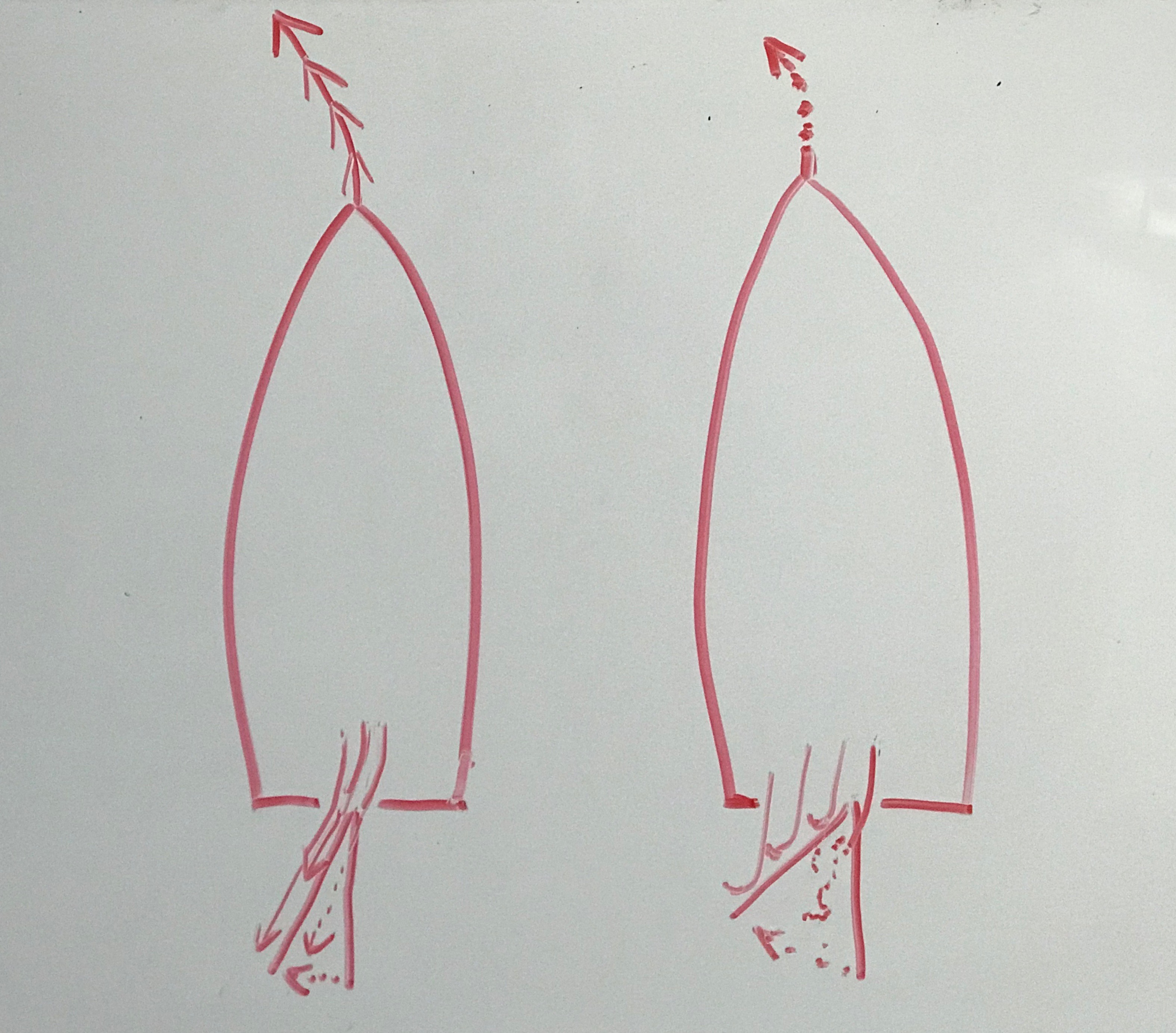
Sorry, only one color still had ink… On your left: outline of a sailboat and its rudder, shown twice – straight, and also cocked slightly to port (left). The curved lines and arrows show how the water would flow over it on both sides and allow good turn initiation. On your right: severe rudder angle typical of many sailors when they make a large turn, especially to tack (cross through the wind quickly). Arrows and squiggly lines show turbulence with little to no water flow. This is what happens if you simply jam the tiller over. What a drag…
It’s slightly counter-intuitive at first. “I want to turn hard, so why not just turn the tiller/wheel hard?” Doesn’t work that way. You’ll get there sooner by starting slower. A slow, steady, linear motion of the tiller (or wheel) gives you everything you need:
Turn initiaiton. Suggests to the boat what you want to do, and it gently begins.
Shaping. We turn the rudder enough to get the turn shape/speed we want.
Completion. So simple – half way through the arc of the turn, we just reverse what we did with the rudder at the same steady rate!
The tiller moves in a linear fashion, but the boat turns in a crescendo/decrescendo. See? We’re teaching to both logical learners and musical/rhythmic ones! If we graph it out, we’ll see different patterns for the tiller and the boat…
On your left: graph of what the tiller motion is like – linear in speed. On your right: the effect this has on both rudder angle and boat’s turn shape: good turn initiation, shaping, and completion. WooHOOO!
The more rudder angle, the greater the turn. To get there, we simply move the tiller steadily to gradually increase rudder angle, and therefore the rate of turn. Your boat will take over, and the rudder will follow. When you feel that, you’ll know you got it right.
Then, you’ll be ready to shred!
Want to learn more about turning a sailboat? See us at NY Sailing Center in the spring. We start in April.
Want to learn how to snowboard?Already ride, but want to improve or take it to the next level? Our Director, Dockmaster and rambling Editor at Large, Captain Card, is a certified snowboard instructor who loves to teach. Hit him up to discuss getting out on snow. This can be as close as Mountain Creek, NJ (an hour from the GWB), as far as South/Central Vermont, or mid way at Hunter or Windham in the Castkills.
Now, one app does it all. iNavX just announced that it’s available for Android. And, it can run Navionics.
One stop shopping. Comes at a price: $30. That’s an expensive app. But it used to be $50, and worth it, even before it integrated with other chart app software. So, you get what you pay for – and sometimes you get rewarded and pay less for it!
Who cares? What’s so special about iNavX?
First, a word or 50 about charting apps. They’re a great resource when you have cell service on the water – which, for most of us, is most of the time. They show where you are in real time just like a dedicated GPS chartplotter but for pennies on the dollar. Even without cell service, you can look at the charts for planning purposes. However, just as with anything else electronic, they can fail, go overboard, or just run out of power. And, you can’t plot a course or position on them with a pencil.
Having said that, most of us want to be using them to supplement our paper charts. It’s just as foolish to swear off them as to over-rely on them.
And now, why iNavX…
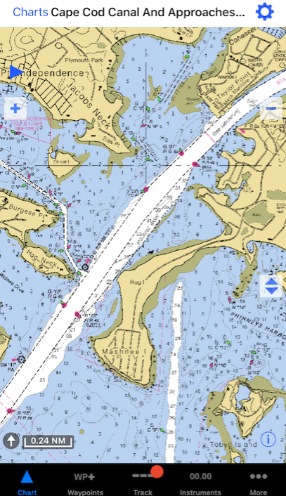
iNavX is the quintessential (if not only) chart app that uses digital imagery of real charts. It’s a static display. What you see on the chart is what you get on the screen. You can zoom in and out, but it’s like cropping a photo. The same stuff is there.
Example of iNavX:
Screen capture of an approach to the Cape Cod Canal from iNavX chart app. This is what the equivalent paper chart would look like, as this is scanned directly from the same file.
Pros:
like we said – what you see is what you get: consistency.
More practice reading the same style chart makes it all faster and easier.
Cons:
not available for all areas.
Must ‘switch’ charts in the app when your position crosses the boundary.
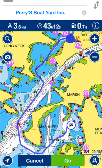
The popular Navionics app uses ‘vector’ scan tech. The app uses its own colors and presentation to display essentially the same data that a chart would, but it is responsive and dynamic. As one zooms in or out, the scale changes. If the user selects a different size area, the amount of detail changes in inverse proportion. Translation: what you see is what the app chooses to show you. Ask for more area, and you get less detail. Stuff disappears.
Example of Navionics:
Navionics display of basically same area and scale as the previous iNavX image. This is vector scanning. Captured from the Navionics web site. Resolution slightly degraded from how it would likely appear in-app, but you get the picture. Different type of display. Nb: the near complete lack of depth soundings – prime example of data disappearing.
Pros:
broad coverage: more regions available worldwide.
seamlessly switches ‘charts’ without interruption or input from user.
Cons:
changing graphics causes visual confusion
inconsistency with paper chart presentation can do the same
both above slow things down
And, like we said – the chief culprit? Stuff disappears. If one zooms out pretty far for ‘small’ scale (large area in smaller detail), reefs and shoals can disappear, and the app doesn’t tell you that it just erased something – including the shoal you were, and still are, aimed at.
A few years ago, a boat in the Volvo Ocean Race ran aground off a tiny island essentially in the middle of nowhere in the Indian Ocean. The area is called the Cargados Carajos Shoals, about 270 miles off Maritius. Everyone on all the boats knew they were going to pass close by one of the islands. One ran aground while sailing at close to 20 knots at night. It’s somewhere between possible and probable that vector scan charting software that was overzoomed contributed to this mistake. Fortunately, no one was hurt. But, the coral was damaged, and the boat was essentially wrecked.
Our recommendation? Get iNavX and be done with it. If you want to play around with vector charts as well, then get the $29 add-on for Navionics and run that within iNavX so you have options at your disposal. In the interest of full disclosure, Navionics alone, outside of iNavX, is $10. It’s called Boating and has a similar logo.
It’s not going well for the formerly very reputable Clipper Round the World Race. So far in this season’s event, one vessel was totaled when it ran aground, and another lost a crew member overboard who tragically didn’t survive.
In the 2015/16 race, one vessel suffered two separate fatalities – a trauma injury aboard, and an overboard fatality.
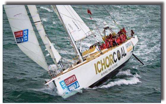
The Clipper Race vessel ICHOR COAL, as shown in the UK’s marine accident report.
So, what’s going on? Is it like the Greek ferry system – enough volume that there will be inevitable accidents – or is something rotten here?
Time will tell, we suppose, but in the meantime, the British Government weighed in after the dual tragedy of the 2015 race, and issued some findings. But first, some background for context…
The Clipper Race is a multi-leg, circumnavigation event with large one-design (basically identical) racing yachts. What sets it apart from the Volvo Ocean Race and other events is the amateur status of the crews. There’s a professional skipper on each vessel, with crew who are not. These amateurs, who pay to play, sign on for anywhere from one leg to the entire event, and go through formal training specific to and run by the event organizers before participating.
This is the 11th running of the Race. It’s had a clean history until 2015. This is trans oceanic racing, and it’s sometimes grueling. Stuff is going to happen from time to time. But, casualties are not expected even for serious offshore racing. Fatalities do occur, but are rare and usually confined to very severe weather events. So, what’s going wrong here?
Perhaps the British Government has some insights. Their Marine Accident Investigation Board convened an inquiry after the 2014 deaths. Their core conclusion? Perhaps one ‘pro’ skipper isn’t enough:
‘While a single employee on board a commercial yacht may provide sufficient company oversight in many circumstances, the special nature of the Clipper Round the World Yacht Race places a huge responsibility on one person to ensure the safety of the yacht and its crew at all times.
‘Therefore, in addition to acknowledging the completed and ongoing actions taken following the two accidents featured in this report, I am recommending Clipper Ventures plc review and modify its onboard manning policy and shore-based management procedures so that Clipper yacht skippers are effectively supported and, where appropriate, challenged to ensure that safe working practices are maintained continuously on board. In particular, consideration should be given to the merits of manning each yacht with a second employee or contracted ‘seafarer’ with appropriate competence and a duty to take reasonable care for the health and safety of other persons on board.’
-Steve Clinch, Chief Inspector of Maritime Accidents, in his Foreword to the “Report on the investigations of two fatal accidents on board the UK registered yacht CV21 122nm west of Porto, Portugal on 4 September 2015 and mid-Pacific Ocean (39° 05.3N, 160° 21.5E) on 1 April 2016”
The report is extensive, and you can read as little or as much as you like on your own here. The quote above is worth noting on its own due to the nature of the event.
Here’s another:
“Although MOB drills had been briefed on board CV21, no practical MOB drills were completed with the crew for the Race leg together, an omission in common with other Clipper yachts.”
-from the synopses of the report.
Several of our own students at New York Sailing Center have gone on to do trans oceanic voyages, including one who participated in the Clipper Race and was himself washed overboard in rough weather but remained tethered to the yacht. Sarah Young, the overboard victim in the 2015 race, was not tethered to the vessel. Simon Speirs, who perished in the current race, was tethered, but the gear failed. Both sailors were lost in gale or near-gale force winds. We sail in those sometimes in Long Island Sound with advanced classes, but it’s not the same. Winds in the 30’s that are ‘offshore,’ or blowing from land to sea, don’t create large waves that can make the vessel pitch dramatically and also break over the boat and literally pick people up and deposit them wherever.
Sarah Young’s failure to clip on in those conditions was an anomaly, but the gear failure that allowed Simon Spiers to be separated from the boat was a testament to the forces involved – and not a totally freak occurrence. In the real rough stuff, it’s been known to happen before in offshore circles.
Given the amateur nature of the Clipper Race crew make up, perhaps there should be rules governing when people may go forward on the boats in rough weather. In this case, it was to do a headsail change. That’s inherently dangerous in large seas. If the necessity to do this is due to the choice of rigging, maybe it needs to be changed. If it’s due to the size of headsails that are allowed, perhaps those should be limited. Perhaps once seas kick up to a certain height that suggests worse to come, but is reasonable at the time, that ought to be the point at which a proactive headsail change is done if the equipment can’t be altered to accommodate staying in the cockpit. If modern furling systems aren’t up to the task of open ocean racing, then that’s the next best thing.
The Clipper yachts use ‘cutter’ rigs, where there are two places to have sails forward on the vessel. That should allow very good flexibility in sail plan choice, and reduce the time spent forward dealing with sails – or potentially eliminate it. I don’t claim to be an expert in open ocean sailing, but if there’s a pattern developing with safety issues in this event, then let’s keep everyone safer – and still on an even keel – with gear changes and strict safety rules that mitigate this risk.
Here’s a link to the UK’s accident report, and also the Clipper Race site…
By now, you’ve probably heard about the two women who were sailing a yacht from Hawaii to Tahiti, and wound up at sea for five months before being rescued from their sailboat, the Sea Nymph. They wound up much closer to Japan than their declared destination by the time they were approached by a tender from a US warship (video at end of post).
Here’s a happy moment after rescue. Apparently, the surf’s up…
Still clip from US Navy footage. One of the rescued women tethered to her surf or SUP board, aboard a navy tender.
The voyage, as they reported it, sounded quite dramatic. Soon after departure, they got caught in a tough storm that cost them their engine and compromised their rigging. And then…
They made distress calls for 98 days with no reply.
Their water purification system failed, but they fixed it.
They departed with a projected 1-year supply of food, but it was 90% gone by the time they abandoned the vessel.
On at least two occasions, sharks showed up and attacked the boat.
After being rescued, they said that that they believed they would have died within 24 hours of when the US Navy arrived.
But, it doesn’t add up. Some of it seemed shaky to this writer when the story first broke, and more questions have surfaced since.
Three of the four now-so-happy campers as a navy tender approaches close aboard. The vessel looks low in the water in this still, but it was just rocking. Boat was floating high and fine. Pic by US Navy.
The rig looked fine. The mast was intact, and the boom was attached with the main roughly secured on it. Barring halyard failure, which wasn’t mentioned, there was no visible reason why the main couldn’t go up. The headsail was smoothly furled up with waiting sheets. The only specific indication in any news report was that there was spreader damage – but the spreaders looked perfect. So, did they sail? Also not mentioned in any news report we saw.
They said they were caught in a “Force 11” storm right after departure, with wave heights to 30 feet and winds to 60 knots – for three days. Or was it more? Depends who you listen to.
“We had no way to realize we were about to enter a typhoon that had winds of 110-150 miles an hour and minimum wave heights of 40 foot in height.”
-from an interview on CNN, according to an article by NPR.
This supposedly cost them their engine, and possibly the proper functioning of their mast or attached rigging and electronics. However, the National Weather Service says there was no “organized storm” activity near Hawaii at the time. NASA satellite imagery confirms. Kinda hard to miss a weather system of this magnitude. (The NWS did issue a small craft advisory for some areas in Hawaiian waters on the day they departed, but that’s pretty f-in far from Force 11.)
The owner of the boat (one of the women on the voyage) claims to have added 6 tons of fiberglass to the 50-foot boat in order to beef it up. Perhaps this was a misprint of some kind, but assuming any part of that was correctly reported by the news outlets – the number, the material, or the unit of measurement ton were correct – it still makes no sense.
Regarding sharks attacking the boat: one of the women said she could hear her own teeth rattle in her head when they rammed it, and they they all lay down together inside the boat and tried to be quiet. She said the sharks could hear them breath, and smell them, and that they told their dogs not to bark. Dog Whisperers?
A 50-foot vessel would be more than twice the length, and probably more than three times, of any sharks they might have encountered. If they brushed up against the boat, or butted their heads against it, no doubt it would have frightened just about anyone. But lets not blow it completely out of proportion. Many sharks use contact to assess whether something is worthwhile (or actual) prey. But even large species, including tiger sharks mentioned in the press, aren’t known to ram vessels far larger than themselves. Sometimes they bite running engines, as the electrical field generated by them mimics that of living things they track and prey on. But this engine was gone, and ostensibly, most of their electronics.
Apparently, that didn’t stop them from communicating near Tahiti, their stated destination, in June. According to the Coast Guard, contact was made with a vessel called the Sea Nymph (same as the womens’ vessel). The captain of the Sea Nymph said they were not in distress and that they intended to make landfall soon. That begs the question of how they basically got to Tahiti, turned around, and then wound up most of the way to Japan. The discrepancy is staggering: between 3,500 and 5,000 nautical miles. This very rough estimate is due to secrecy of the US Navy on final position, which was approximately 900 miles from Japan.
They reported that they had six forms of communication when they departed, and that all failed. That in itself is somewhat suspicious. One was a cell phone that went overboard soon after departure. Fair enough. I didn’t see a list of all the others anywhere yet. But the most interesting one of all was the EPIRB. This didn’t actually fail. TURNS OUT… It was never used! They didn’t mention having one in their initial interviews. But when the Coast Guard got through with them (and perhaps they’re not yet), they said they had one and chose not to deploy it. An EPIRB is a satellite based rescue beacon that is highly reliable, and would almost certainly have resulted in their position being known. They said in retrospect that there were two occasions where they should probably have activated it. The owner contradicted herself somewhat regarding EPIRB use. On the one hand, she said in interviews that when they were found, they believed they wouldn’t have survived another 24 hours. But she also told the Coast Guard that in her “experience” (her language), they shouldn’t be deployed unless death is imminent within 24 hours.
Speaking of this 24-hour threshold, it’s quite completely unclear why they felt they had only about 24 hours left to live. Reports were somewhat conflicted, but according to ABC News, the owner said they could not speak on why they felt they only had 24 hours left. She stated very specifically:
“I would love to answer that question now. I’m not actually allowed to answer that as long as we are on the vessel,” Appel said before going on to detail how their sailboat was damaged while it was being towed by the Taiwanese vessel.
“The pictures speak a thousand words. It is absolutely phenomenal the amount of damage that they did to the structure of that boat. So that kind of help speaks for itself.”
(They reported that they were first discovered by a Taiwanese fishing vessel, and that the owner swam from her vessel to this one to make a radio distress call. (HEL-lo: sharks?????). Sounds like they were taken in tow at some point for some undisclosed amount of time, and they make it sound like this damaged their vessel. )
Their two dogs and they looked surprisingly healthy upon rescue despite all this.
And now, the video clip we promised…
If/as more details come to light, we’ll report and poke around here.
It’s the name of a Cable TV show that NY Sailing Center was featured in once, and it’s also an internal mandate at the good old US Navy with the help of some Congressional pressure as well.
After several well publicized collisions in foreign waters, resulting in loss of life, the navy took stock. The findings were basically this:
watches (shifts on duty) were often too long;
systematic evaluation of risk of collision wasn’t being done;
stealthing (cloaking/hiding) were making it harder for other vessels to see warships
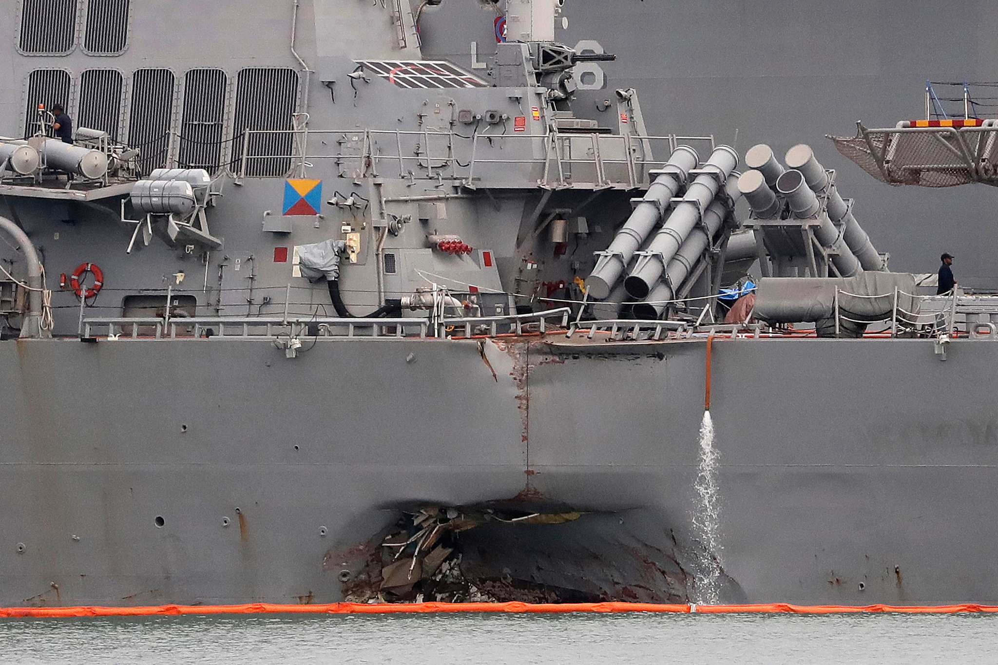
Navy destroyer John S McCain after collision recently.
While vessels at war really don’t want to be seen until you’re sunk (or at least until they’ve fired at you), it’s becoming a problem in some heavily trafficked areas. Most large vessels, recreational included, use electronic tracking (AIS) that broadcasts direction, speed, and vessel info to other vessels nearby. This is the opposite of radar, where vessels look for others they don’t know about. If both are used systematically, along with a well placed visual lookout, then there should never be any collisions.
Of course, it’s never as simple as that. And in the case of warships, they are off the radar – literally, sometimes, as they’re designed to be poor ‘targets’ for it. That means radar doesn’t easily pick up warships. They’re built that way. Warships also use fewer lights, and sometimes don’t use AIS. When they do, they don’t always provide as much information as other vessels.
Senator John McCain recently took an Admiral to task over all this. Coincidentally, the warship named after him was involved in a collision. More on that in the article we link to below.
I’ve never used AIS, but have enough experience with radar both in ‘school’ and in real life to understand the difficulties involved. Even if there’s a dedicated radar observer, it can be hard to identify things in the dark and be sure about what they’re doing. Once a warship disables AIS, and visibility is poor, it’s risky business on the high seas.
The same re-focus on basics applies to navigation in the sense of getting from A to B without hitting C (the subtitle of our own coastal navigation text book). The US Coast Guard routinely cites failure to keep a dead reckoning plot (speed, time, distance calculations) as a factor in groundings of commercial vessels. All the bells and whistles don’t ring themselves. That’s why courses on traditional methods of navigation are needed now more than ever, with everyone getting distracted with their gadgets.
Here’s a link to the New York Times article that reported on this recently, which has links to other previous articles that help complete the fuzzy radar picture…
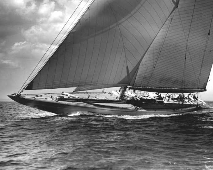
The J Class is an awesome and venerable racing design. They go back to at least 1929, with roots extending back to the origin of the America’s Cup. They were the stuff of inspiration for many a noted marine photographer (including Stanley Rosenfeld).
J-Class yacht of older vintage, photographer unknown.
Now, they’re back! Modern renditions of this traditional design are out shredding up the race course, so to speak. To my delight, I saw that they are holding a world championship.
The J-Class design, sometimes called a J Boat, should not be confused with the modern designer and manufacturer J/Boats. This very successful line of racers and racer/cruisers is altogether different. The very popular J/24 is one of the most important sailing designs ever created due to how extensively it was raced, but it made a piss-poor learning platform. It is still widely used for that due to the abundant availability of cheap older boats – not because they are well suited to teaching sailing. There are over 5,500 of them around the world.
There are over 5,000 International Folkboats, too, and we have one – but wouldn’t use it for learn-to-sail instruction, and we wish people would steer clear of J/24’s for that purpose as well. The Folkboat has very traditional lines that are reminiscent of J-Class yachts.
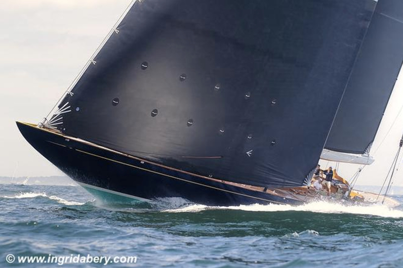
I was struck once again by the simple, elegant beauty of these large beasts of boats when I saw some pics by Ingrid Abery. I’ve taken the liberty of pasting one of her copyrighted images here to tempt you to see more on her site.
It’s not running a boat onto a coral reef.Some people do that of course, but that’s just called running a boat onto a coral reef.
“Reefing” is bypassing part of a sail so it’s temporarily smaller.It’s done when a boat is overpowered, or about to be, by increasing wind.It can be done with almost any mainsail, which is the one attached behind the mast, and some genoas, which attach to the front wire supporting the mast (headstay or forestay).
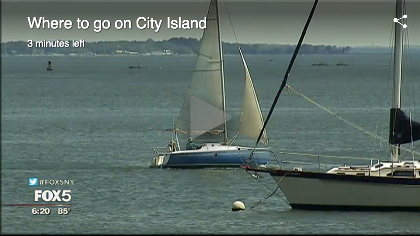
Here’s one of our Beneteau First 21 sloops sailing conservatively with a reef in the main, and the small jib (front sail that doesn’t pass the mast). It was windy and gusty that morning as we prepared to be interviewed and filmed by Fox 5 News. There’s a link below to the story and video on their site, which shows this reefed mainsail well…
“Closer Than You Think:” summer series on Fox 5 News. This episode was about City Island, and they visited us at NY Sailing Center. Click the pic or follow the link below to see the video.
The details differ, but the concept is the same.Smaller sails equal less power.Less power means the boat doesn’t lean (heel) to the side as much.Too much healing to one side makes the boat try to turn the other way (due to buoyancy and deflection and other mumbo-jumbo), and there’s less control.It’s also somewhat uncomfortable and potentially a little dangerous if people slide downhill, so to speak, when the boat heels too much.Most people find heeling fun, but it can freak out beginners until their body accepts what their mind keeps telling them: sailboats are meant to heel, and it’s not inherently dangerous.
So, back to reefing.
It’s a powerful tool to reduce heeling, and not only gives the boat more control, but maintains its speed.Yes, that’s right.Less power can equal more speed.Why?Sailboats are less efficient moving through the water when heeled too much, and the turning effect causes the rudder (steering fin) to be held to one side just to go straight. That’s basically a brake.
Reef the mainsail, and it’s smaller.Less power.Less heeling.
But wait – there’s more!(or is that less?)The sail is also lower.When it’s reefed, the bottom is bypassed, so the sail isn’t raised as high on the rig.Less height equals less leverage.Even less heeling.
But there’s a third benefit that’s less obvious.Who can figure this one out?If you learned to sail with us, you might remember this one. Post a comment in reply to this if you think you have the answer!
Here’s a link to the Fox 5 News piece, “Closer Than You Think: City Island.” Check out City Island’s nautical heritage; see us at NY Sailing Center – and take a good look or three at that reefed mainsail!..
That’s the deal with City Island, which Fox 5 covered as part of an ongoing summer series. They’re featuring places worth seeing in NYC that are, well… closer than you think.
Reporter Christal Young and crew swung by City Island recently to check out its maritime heritage and flavor. They hit the Nautical Museum and visited us at NY Sailing Center as well. Of course, we went for a sail.
How close is City Island? As they say on Fox, Closer Than You Think. Want to drive from UWS or UES? 20-30 minutes if no traffic. Taking public? 45′ to an hour and 20′ from UWS or UES depending on connections. We can usually pick you up from Pelham Bay Park, where the 6 train ends (and when we drop you back off, there’s usually a 6 waiting for you to step aboard). It’s also accessible by Metro North with a short taxi connection or again, us picking you up. (About 30′ on Metro North from Grand Central to Pelham is typical.) When we pick you up, you can shave 10-15′ off the travel time, too.
It takes less time to get to us from UES for example than it does to get to New Jersey, where several “NYC” schools actually make you come to sail their boats – including one school/club with “Manhattan” in it’s name!
Even if it takes longer for you to get to us, you get far better sailing. Why save time to get to the Hudson River and New York Harbor, and basically waste the entire day dodging commercial shipping, ferries, strong currents, narrow passages, and wicked wind shears from tall buildings? Come to City Island, and the entire day on the water is productive and fun. Look out toward Hart Island, Long Island and the Sound, and it’s hard to believe you’re still in NYC.
Click the image above or the link below to see the video on Fox’s site or read the short print story. See why Christal spoke what we show above in quotes. Follow the link back to us (New York Sailing Center) if you’re stoked about seeing how we can get you sailing in Long Island Sound this summer or fall!
We’re overdue for a good old fashioned product review. This one’s a Part II after a few solid years of use, and a little abuse.
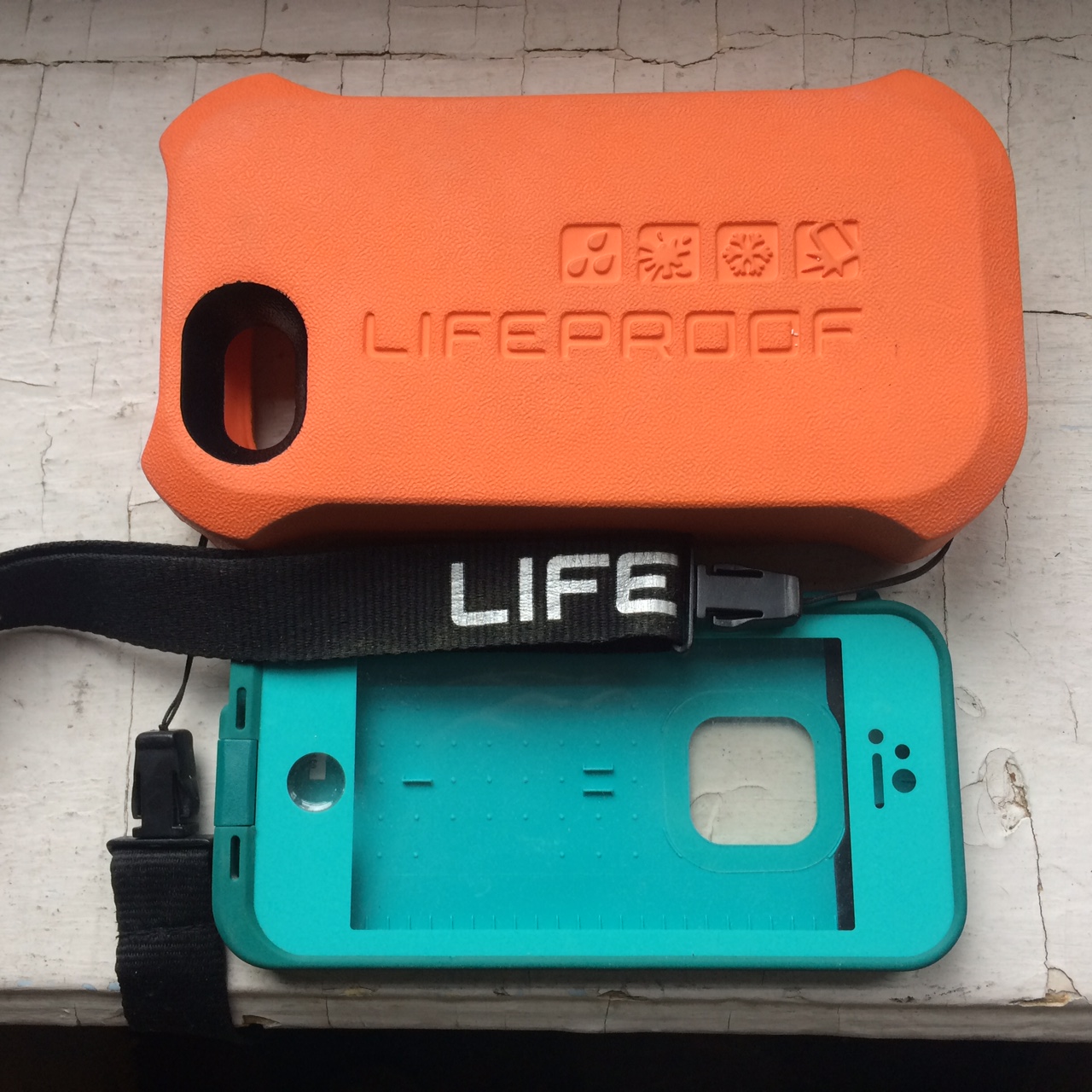
Lifeproof is a well known and very popular manufacturer of water and shock resistant cases for phones and tablets. They make sleek, form fitting products that are exactly customized to specific devices, and are generally well thought out to give full functionality so that the device can just stay in the case.
The Lifeproof “Life Jacket” and iPhone case for the 5 series, with a suitably rugged backdrop.
I’ve used their cases for iPhone 4 and 5 series phones. I was stoked about them at first, until they seemed to wear out prematurely. I’ll go on record right now as saying that I’m rough on gear. So, when I had trouble with my iPhone 4 case wearing away and falling apart, I thought it was me, but I put in a warranty claim anyway, and, BAM. New case for free. Good customer service!
The only problem is that it kept happening. First, the 4, and then with the 5. On our last Instructional Sailing Vacation trip in the Virgin Islands, one of the new cases leaked while snorkeling and almost ruined my phone. I saved it with fresh water and then electrical contact cleaner, but it malfunctioned for a week and caused me some trouble with calls. (Yes, I did a proper water integrity test before putting the phone in. And, yes – I got some really kewl video footage of marine life for you that’s on our Instagram.)
As well as the wearing-away issue and the leak, the buttons that control the volume on/off switch, and the microphone port sealing screw, failed on two different replacement cases.
The case comes with a mic/headset adaptor that seals the phone when using either. That protects the phone if the connection gets wet, and only the mic/headset is at risk. However, they never worked properly with any kind of headset.
In my humble opinion, my issues boil down to two things:
Lifeproof made an accessory called the Life Jacket for the 4 and 5 series phones. It’s a bulky foam-rubber case that floats the device and also provides way more shock resistance. It actually blocks wind noise for phones, too. Unfortunately, the Life Jacket is very hard to get on and off the case, and wears it down quickly. Must be done, as there’s no way to charge the phone with the Life Jacket on. (Never got around to trying some Exacto-knife surgical modifications.)
Durability issue with original cases, compounded by poor quality control in manufacturing of replacements. New cases had halves that didn’t line up well, were warped, broke easily without using the Life Jacket, and in one case arrived with a loose broken part that had nothing to do with packing and shipping.
Sure, the company gladly kept sending replacements, and they made an easy process easier. (I had to wonder if that reflected growing problems with quality and higher return rates.) However, when I got fed up and asked more questions about where they were made, and whether I could expect better quality replacements for later models (6 and 7 series phones), I got a meaningless first response and no answer to a follow up.
So, I’m stuck with kewl Life Jacket accessories and broken cases.
There’s growing competition for this style of drop & drink resistant case for mobile devices. One manufacturer, who has been around for decades making similar products, is Pelican. They now make an iPhone case for the iPhone 6 and 6plus series phones that looks very similar to the Lifeproof products. I might have to give them a try despite the lack of Life Jacket and figure out a workaround.
At least one if not several companies make dedicated snorkeling cases for the iPhone as well. One is the TAT7 iPhone Scuba Case. It’s a simple, clear case that has three dedicated buttons: home screen, camera app, and shutter. It’s rated for depths up to 100 feet. Once the phone is in, all one can do is shoot and stop (and toggle between pic and video, apparently). It has a built in wrist strap, which the Pelican doesn’t appear to. Looks worthy of consideration. (Couldn’t find a dedicated web site so that might be a slight red flag, but they are in product reviews and on Amazon.)
Anyway, here are links to Lifeproof and Pelican so you can do your own research and make your own decisions…