Now, one app does it all. iNavX just announced that it’s available for Android. And, it can run Navionics.
One stop shopping. Comes at a price: $30. That’s an expensive app. But it used to be $50, and worth it, even before it integrated with other chart app software. So, you get what you pay for – and sometimes you get rewarded and pay less for it!
Who cares? What’s so special about iNavX?
First, a word or 50 about charting apps. They’re a great resource when you have cell service on the water – which, for most of us, is most of the time. They show where you are in real time just like a dedicated GPS chartplotter but for pennies on the dollar. Even without cell service, you can look at the charts for planning purposes. However, just as with anything else electronic, they can fail, go overboard, or just run out of power. And, you can’t plot a course or position on them with a pencil.
Having said that, most of us want to be using them to supplement our paper charts. It’s just as foolish to swear off them as to over-rely on them.
And now, why iNavX…
iNavX is the quintessential (if not only) chart app that uses digital imagery of real charts. It’s a static display. What you see on the chart is what you get on the screen. You can zoom in and out, but it’s like cropping a photo. The same stuff is there.
Example of iNavX:
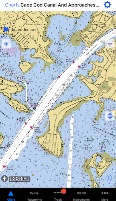
Pros:
- like we said – what you see is what you get: consistency.
- More practice reading the same style chart makes it all faster and easier.
Cons:
- not available for all areas.
- Must ‘switch’ charts in the app when your position crosses the boundary.
The popular Navionics app uses ‘vector’ scan tech. The app uses its own colors and presentation to display essentially the same data that a chart would, but it is responsive and dynamic. As one zooms in or out, the scale changes. If the user selects a different size area, the amount of detail changes in inverse proportion. Translation: what you see is what the app chooses to show you. Ask for more area, and you get less detail. Stuff disappears.
Example of Navionics:
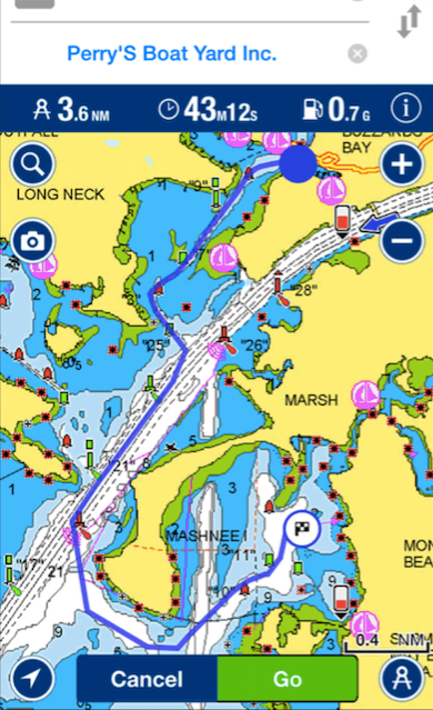
Pros:
- broad coverage: more regions available worldwide.
- seamlessly switches ‘charts’ without interruption or input from user.
Cons:
- changing graphics causes visual confusion
- inconsistency with paper chart presentation can do the same
- both above slow things down
- And, like we said – the chief culprit? Stuff disappears. If one zooms out pretty far for ‘small’ scale (large area in smaller detail), reefs and shoals can disappear, and the app doesn’t tell you that it just erased something – including the shoal you were, and still are, aimed at.
A few years ago, a boat in the Volvo Ocean Race ran aground off a tiny island essentially in the middle of nowhere in the Indian Ocean. The area is called the Cargados Carajos Shoals, about 270 miles off Maritius. Everyone on all the boats knew they were going to pass close by one of the islands. One ran aground while sailing at close to 20 knots at night. It’s somewhere between possible and probable that vector scan charting software that was overzoomed contributed to this mistake. Fortunately, no one was hurt. But, the coral was damaged, and the boat was essentially wrecked.
Our recommendation? Get iNavX and be done with it. If you want to play around with vector charts as well, then get the $29 add-on for Navionics and run that within iNavX so you have options at your disposal. In the interest of full disclosure, Navionics alone, outside of iNavX, is $10. It’s called Boating and has a similar logo.
Happy Hunting!