Lighting up a Light House

A client of ours is originally from Canada, and two buddies and he did 103 and 104 with us one season before doing their first bareboat charter in the BVI.

Adam’s uncle got involved with a latent lighthouse in Ontario, Canada. He’s on the local preservation committee, and had been trying to get it lit back up. Apparently, it was a somewhat uphill battle as there were concerns about the light shining on shoreside homes at night and being intrusive.  The major’s office was involved and favored the light being back on, so that helped.
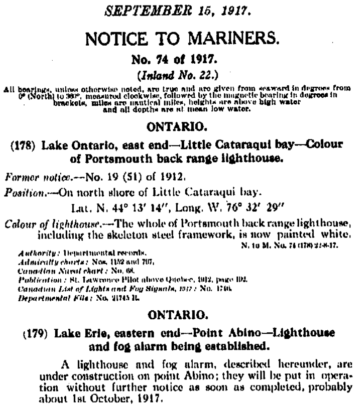
Here’s an excerpt from the original Notice to Mariners in 1917 that announced the construction of this light!..
For its return, the compromise was to aim the light across the bay at another peninsula rather than sweep across the shore or just aim 360 all around.  Our mission: confirm the exact bearing, and show/explain why we came up with the magic number.
(Truth be told, Adam was more than capable of doing this himself, having successfully taken and passed 103, 104 and 105 with us and then applied it in the BVI. But this had to come from us as the outside experts.)
Anywho, Adam enlisted us to be the alleged experts to plot the angle of the light and show how we’d done it.

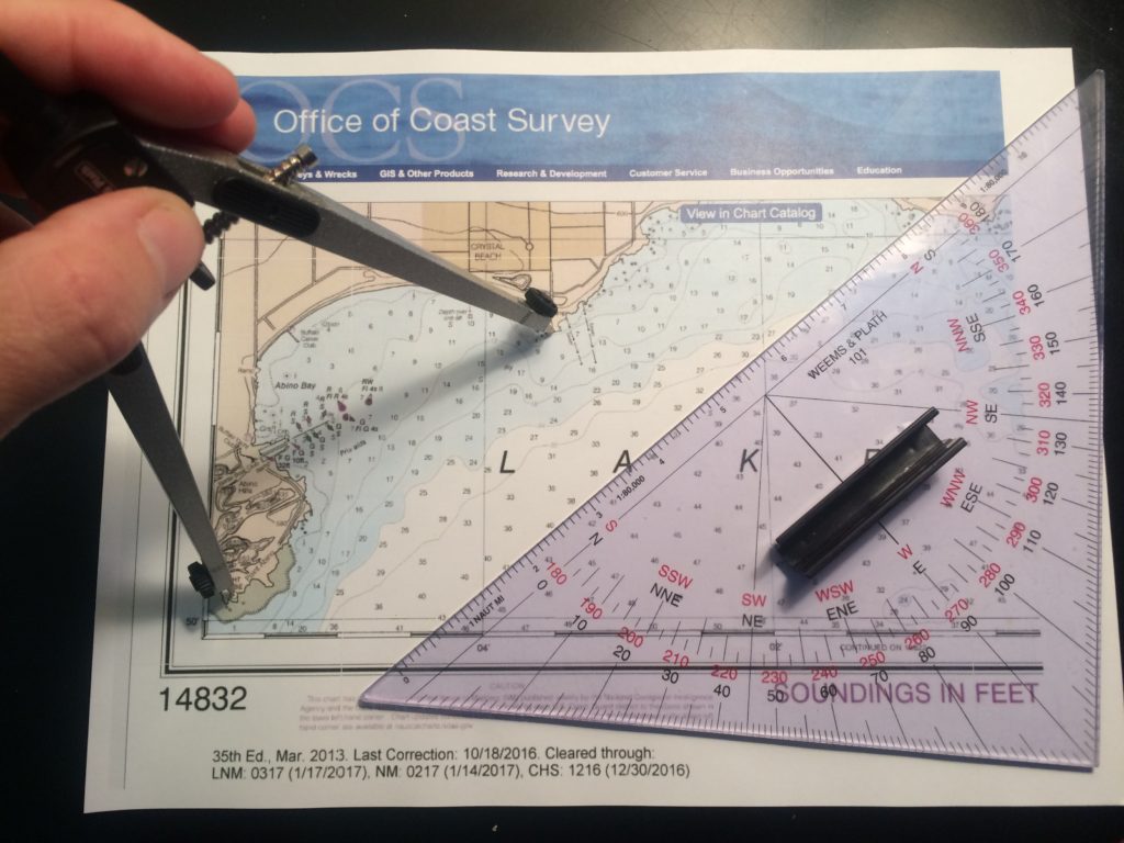
Dividers (nautical drafting compass) set exactly on the two points; protractor triangle was laid carefully against them to be on the correct bearing. Then, triangle was carefully moved to a meridian of longitude to read the bearing in true degrees. This was converted to magnetic so bearings could be taken from either point in real time to confirm.
1. Get the right chart.  Adam took care of this: NOAA #14832, Upper Niagara River, ending in Lake Erie.

2. ID the light in question: “Light House,” on Point Abino.  No characteristics shown as it’s idle.

3. ID the exact spot the new light is supposed to be aimed at: SW corner of the peninsula across the bay at the other end of Crystal Beach.
4. Measure the bearing painstakingly several times with at least two methods and get a consistent answer: 61 degrees magnetic.

There you have it.  And thar she glows…

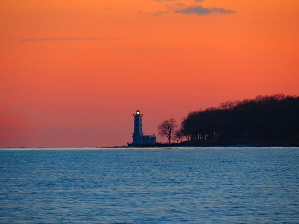
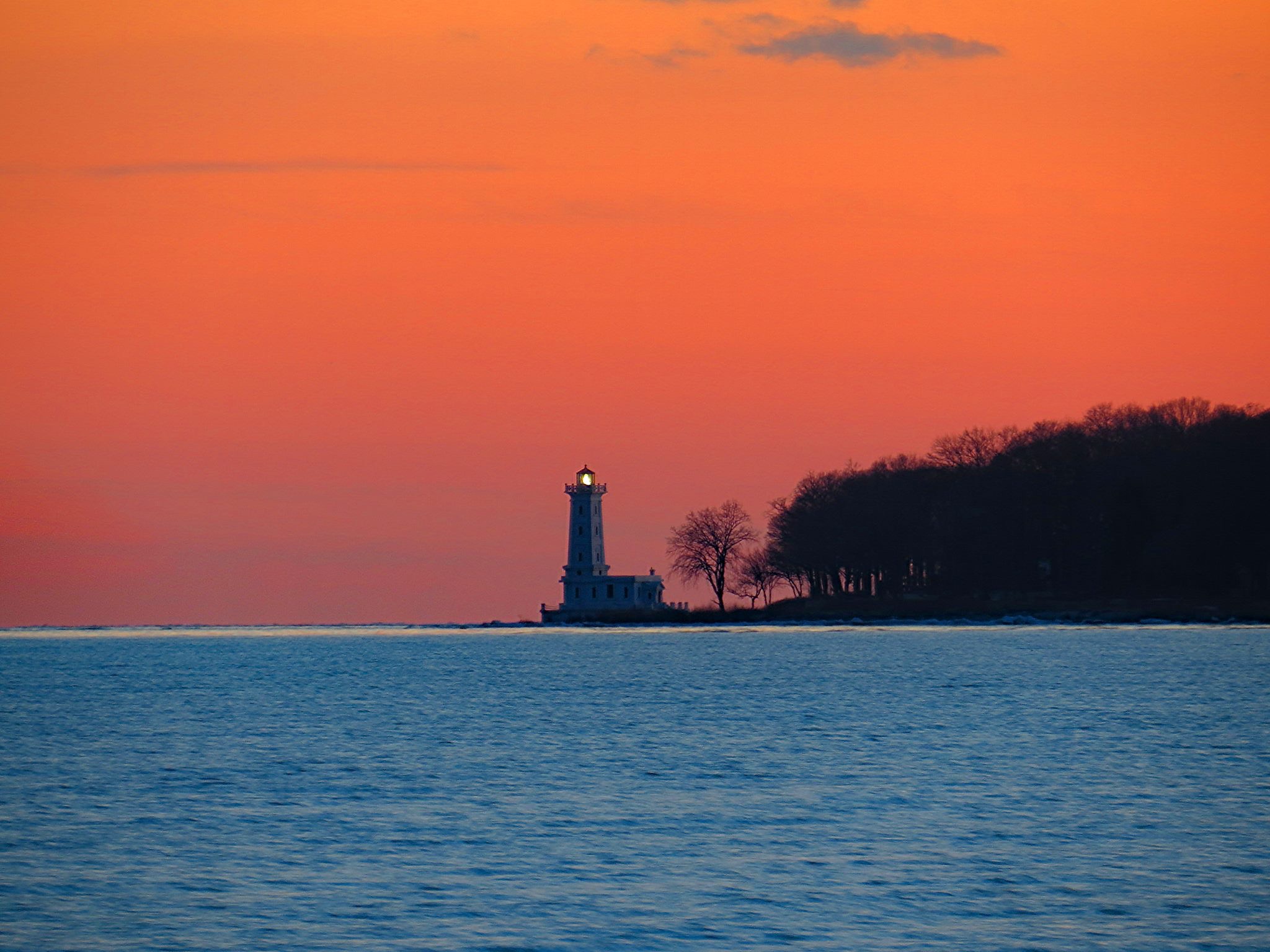
The light house at Point Abino, Ontario, with its beacon aimed back across the bay.

“A school has no name…”

…or is it no location?  Or too many, so a school is confused about where it is?

Do two (or three) wrongs make a right (location)?

Wonder what percentage of you get the GoT reference of this post’s title. (If you don’t get GoT, let us know and we’ll bring you up to speed.)

Hint…

GoT final scene
Wings over water – on sailboats and soaring dragons. Final scene of season six finale, Game of Thrones.

WTF am I talking about?  Sailing schools who are geographically challenged and are either so confused they don’t know where they are – or want you to be so you sign up for their school at one of their dubious digs.

Example: a school is named after a geographic location.  An island.  They had to move from that island to a neighboring state.  They still reference teaching at that original island in their blurb on the ASA School’s page. But a girl has to cross a river to get to them.  (oops; there’s another GOT reference…)

Another example: a school has three locations, none far from the others (and all in our state).  One moved across the bay it’s located in.  Map page still shows it where it isn’t.  At least it’s the right bay.   One is entirely new.  It’s listed on the ASA page as being in a particular Bay, where they say the sailing is Great.  But a school is not in this bay.  It is in another, far away, and the sailing is not in this tiny bay.  A school sails in an inlet on an ocean. (And a school cannot hide from that ocean’s swells.)

What do we care?  We like good old fashioned, straight up honest advertising.  Plus, we’re very proud of our location.  It’s extremely accessible from so many places, both by public transit and car.  The area is insanely good for teaching sailing and just enjoying a day sail or a cruise.

Some schools have multiple locations.  Some locations have multiple schools.  Tiny little City Island, barely a mile and a half long, has historically been home to two sailing schools – sometimes just one, and for a time, three.  Plus, it has two college sailing teams.  Both those universities have campuses on Manhattan.  But, they sail out of City Island.  Finally – we have three yacht clubs on the Island and the vast majority of their members’ toys are sailboats.

We have had opportunities to add a satellite location at the “bay on the ocean,” on the Hudson, etc.  We have always declined.  Not worth having a location slightly more convenient to Manhattanites, or to spread ourselves around hoping to capture another demographic, just to take clients’ money and give them a piss-poor education and experience that, if they even learn properly from, they’ll soon outgrow.

A school has an ethic.

Bareboat 104: Cruise to Oyster Bay

We did the first weekend of a Bareboat Cruising course (ASA 104) on the 11th and 12th.  Marc and Sheri, prior grads and ongoing Sailing Club members, wanted an overnight cruise experience as part of their training.  We decided on Oyster Bay.  Say hi to Marc & Sheri…
m and s
Evening on Oyster Bay
Moderate, slightly gusty breezes tapered off as we departed, so it was light winds all the way.  They became variable in direction as well so it was a good challenge to keep the boat moving.  Too many people just give up in these conditions, and never learn to actually sail a boat in them.  This is one of the fascinating challenges in sailing, and as Long Island Sound and the Northeast are light-wind regions, it’s a critical skillset to develop.  We did motor-sail briefly when it was futile to sail. After all, there was a sunset to catch while relaxing on the mooring!
ob sunset
Hard to get tired of this vista!

We arranged for a mooring and the timing was perfect.  After the yacht club’s sunset cannon went off, we walked into town in time for our dinner reservation at Wild Honey.  Appetizers and entrees were all excellent as usual.  We did have to reject the first bottle of wine, but the replacement was fine.

The next day saw winds increase beyond what had been originally forecast.  We expected Northwest winds of 10-15 with gusts to 20.  We were greeted with 20-30 from WNW.  Higher gusts were to be possible. So, after taking our time with breakfast and boat prep, and preparing quick access sandwiches and snacks (as well as water), we headed out with our smallest genoa and a single reef in the main.  First thing we encountered in the mouth of the bay? A fleet of little Optis zipping all over in perfect control, and one chase boat seemingly with nothing to do.  We knew we then had no choice but to tough it out on our Pearson 10M (33-foot) keelboat!  (Opti, short for Optimist Pram, is the most popular kids training boat in the world.  We see them everywhere we cruise in the Caribbean and Mediterranean.)
m and c
Marc honing his helm chops while our Director and Dockmaster, and HBIC (Head Bozo in Charge), Captain Stephen Glenn Card sort of hangs around.

But it wasn’t a big deal despite a confused sea state with short choppy waves.  Kilroy ate it up with a balanced helm.  The seas became more rhythmical the further west we progressed.  But after a brief lulling of the breeze to mid-teens, it picked back up.  By the time we had to negotiate the entrance to City Island Harbor, winds were 30-35.  That’s getting into gale forces.  Whew!  But the boat and crew both took it in stride and it was a rewarding finish to a fine trip.